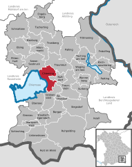
- Chieming
-
Chieming 
Coordinates 47°54′N 12°32′E / 47.9°N 12.53333°ECoordinates: 47°54′N 12°32′E / 47.9°N 12.53333°E Administration Country Germany State Bavaria Admin. region Upper Bavaria District Traunstein Mayor Benno Graf (UWG) Basic statistics Area 37.74 km2 (14.57 sq mi) Elevation 537 m (1762 ft) Population 4,538 (31 December 2010)[1] - Density 120 /km2 (311 /sq mi) Other information Time zone CET/CEST (UTC+1/+2) Licence plate TS Postal code 83339 Area code 08664 Website www.chieming.de Chieming is a municipality in the district of Traunstein in Bavaria, Germany.
Etymology
The name Chieming, Chiemsee and the name of the area Chiemgau go back to the Old High German personal name Chiemo (7./8. century). At the end of the 8th century the name Chiemgau appeared for the first time in documents as Chimigaoe but it stood at that time for a smaller area around the village of Chieming.
References
- ^ "Fortschreibung des Bevölkerungsstandes" (in German). Bayerisches Landesamt für Statistik und Datenverarbeitung. 31 December 2010. https://www.statistikdaten.bayern.de/genesis/online?language=de&sequenz=tabelleErgebnis&selectionname=12411-009r&sachmerkmal=QUASTI&sachschluessel=SQUART04&startjahr=2010&endjahr=2010.
Altenmarkt an der Alz | Bergen | Chieming | Engelsberg | Fridolfing | Grabenstätt | Grassau | Inzell | Kienberg | Kirchanschöring | Marquartstein | Nußdorf | Obing | Palling | Petting | Pittenhart | Reit im Winkl | Ruhpolding | Schleching | Schnaitsee | Seeon-Seebruck | Siegsdorf | Staudach-Egerndach | Surberg | Tacherting | Taching am See | Tittmoning | Traunreut | Traunstein | Trostberg | Übersee | Unterwössen | Vachendorf | Waging am See | Wonneberg

This Traunstein district location article is a stub. You can help Wikipedia by expanding it.


