- Marquartstein
-
Marquartstein 

 MarquartsteinLocation of Marquartstein within Traunstein district
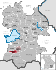
Coordinates 47°45′31″N 12°27′42″E / 47.75861°N 12.46167°ECoordinates: 47°45′31″N 12°27′42″E / 47.75861°N 12.46167°E Administration Country Germany State Bavaria Admin. region Upper Bavaria District Traunstein Municipal assoc. Marquartstein Mayor Andreas Dögerl Basic statistics Area 13.41 km2 (5.18 sq mi) Elevation 530-800 m Population 3,226 (31 December 2010)[1] - Density 241 /km2 (623 /sq mi) Other information Time zone CET/CEST (UTC+1/+2) Licence plate TS Postal code 83250 Area code 08641 Website www.marquartstein.de Marquartstein is a municipality in the southeastern part of Bavaria, Germany and is part of the Verwaltungsgemeinschaft Marquartstein and Staudach-Egerndach. It is situated in a region called Chiemgau, approximately 10 km south of Lake Chiemsee between Munich and Salzburg, , and 30 km west of Salzburg. Most of the area is situated in the valley of the river Tiroler Achen, which separates the village into two parts. Marquartstein is at the edge of the Alps. Its geographical location is 47°46′N 12°28′E / 47.767°N 12.467°E.

Brief history
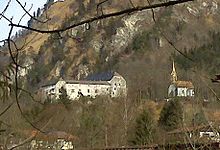
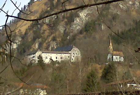
- 1075: the castle was founded
- 1803: Pflegamt (municipal jurisdiction) was united with the court in Traunstein
- 1857: the castle ruin was rebuilt by Cajetan Freiherr von Tautphoeus
- 1884: railway from Übersee was built
- 1890-1908 The composer Richard Strauss lived in Marquartsein
- 1958 Romanian-American actress Tala Birell was buried in the village
- 1978: Marquartstein becomes head of the Verwaltungsgemeinschaft Marquartstein and Staudach-Egerndach
Education
Marquartstein is the local centre which has a primary school, the Landschulheim Marquartstein (a Gymnasium and boarding school), a Realschule and Niedernfels ( a Roman Catholic primary and secondary school)
Altenmarkt an der Alz | Bergen | Chieming | Engelsberg | Fridolfing | Grabenstätt | Grassau | Inzell | Kienberg | Kirchanschöring | Marquartstein | Nußdorf | Obing | Palling | Petting | Pittenhart | Reit im Winkl | Ruhpolding | Schleching | Schnaitsee | Seeon-Seebruck | Siegsdorf | Staudach-Egerndach | Surberg | Tacherting | Taching am See | Tittmoning | Traunreut | Traunstein | Trostberg | Übersee | Unterwössen | Vachendorf | Waging am See | Wonneberg
References
- ^ "Fortschreibung des Bevölkerungsstandes" (in German). Bayerisches Landesamt für Statistik und Datenverarbeitung. 31 December 2010. https://www.statistikdaten.bayern.de/genesis/online?language=de&sequenz=tabelleErgebnis&selectionname=12411-009r&sachmerkmal=QUASTI&sachschluessel=SQUART04&startjahr=2010&endjahr=2010.
Categories:- Municipalities in Bavaria
- Traunstein district
- Upper Bavaria geography stubs


Wikimedia Foundation. 2010.