- Hoath
-
Coordinates: 51°20′00″N 1°09′27″E / 51.3334°N 1.1576°E
Hoath 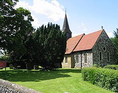
Holy Cross Church, Hoath
 Hoath
Hoath
Hoath shown within KentOS grid reference TR200641 District City of Canterbury Shire county Kent Region South East Country England Sovereign state United Kingdom Post town CANTERBURY Postcode district CT3 Dialling code 01227 Police Kent Fire Kent Ambulance South East Coast EU Parliament South East England UK Parliament Canterbury List of places: UK • England • Kent Hoath is a village and civil parish situated within the City of Canterbury local government district. The hamlets of Knaves Ash, Maypole, Ford, Old Tree, Shelvingford and Stoney Acre are included in the parish.
Geography
Within Hoath there is a small primary school, a camp site called Southview Camping, a pub/restaurant (the Prince of Wales), a small church and village hall. In the village there used to be a small shop but it closed down due to lack of business. There is a small general aviation airfield (ICAO: EGHB) near Maypole.
External links
- www.hoath.org - village website with news, upcoming events and a history of the village
- Maypole Airfield official site
Towns and villages in the Canterbury district of Kent, England 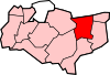 Adisham • Barham • Bekesbourne • Beltinge • Bishopsbourne • Blean • Boyden Gate • Bramling • Bridge • Broad Oak • Broomfield • Chartham • Chartham Hatch • Chestfield • Chislet • Eddington • Fordwich • Grays • Hackington • Harbledown • Hawthorn • Herne • Herne Bay • Hersden • Hillborough • Hoath • Ickham • Kingston • Littlebourne • Lower Hardres • Marshside • Nackington • Patrixbourne • Petham • Pett Bottom • Reculver • Rough Common • Stuppington • Sturry • Swalecliffe • Tankerton • Thanington Without • Tyler Hill • Upper Harbledown • Upper Hardres • Upstreet • Waltham • Westbere • Whitstable • Wickhambreaux • Wincheap • Womenswold • Woolage Green • Woolage Village • YorklettsCategories:
- Villages in Kent
- Canterbury
- Kent geography stubs


Wikimedia Foundation. 2010.