- Chestfield
-
Coordinates: 51°21′18″N 1°03′50″E / 51.355°N 1.064°E
Chestfield 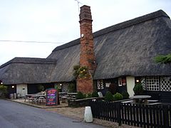
Chestfield Barn
 Chestfield
Chestfield shown within KentPopulation 2,915 [1] OS grid reference TR132657 Parish Chestfield District City of Canterbury Shire county Kent Region South East Country England Sovereign state United Kingdom Post town CANTERBURY Postcode district CT5 3 Dialling code 01227 79**** Police Kent Fire Kent Ambulance South East Coast EU Parliament South East England UK Parliament Canterbury List of places: UK • England • Kent Chestfield (pronounced /ˈtʃɛstfiːld/) is a village (and civil parish and with Swalecliffe a district council ward) in the Canterbury District of Kent, England. The parish is located a mile or so from the sea on the north coast of Kent, between the towns of Whitstable and Herne Bay. It is approximately five miles (8 km) north of Canterbury.
Chestfield & Swalecliffe railway station lies on the Chatham Main Line, which runs between Chestfield and Swalecliffe.
The Chestfield Barn originated as part of the Chestfield Manor in the 14th century, a possession of the half-brother of William the Conqueror, Odo, Bishop of Bayeux. It is believed that the Manor dates back to as early as 1084, particularly as it is mentioned in the Domesday Book of 1086. In the early part of the 20th century the barn was converted into a golf house by Abe Mitchell, to service the 700-acre (2.8 km2) golf course constructed in 1924 by George Reeves.
References
- ^ National Statistics Census 2001
External links
Towns and villages in the Canterbury district of Kent, England 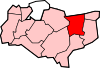 Adisham • Barham • Bekesbourne • Beltinge • Bishopsbourne • Blean • Boyden Gate • Bramling • Bridge • Broad Oak • Broomfield • Chartham • Chartham Hatch • Chestfield • Chislet • Eddington • Fordwich • Grays • Hackington • Harbledown • Hawthorn • Herne • Herne Bay • Hersden • Hillborough • Hoath • Ickham • Kingston • Littlebourne • Lower Hardres • Marshside • Nackington • Patrixbourne • Petham • Pett Bottom • Reculver • Rough Common • Stuppington • Sturry • Swalecliffe • Tankerton • Thanington Without • Tyler Hill • Upper Harbledown • Upper Hardres • Upstreet • Waltham • Westbere • Whitstable • Wickhambreaux • Wincheap • Womenswold • Woolage Green • Woolage Village • Yorkletts
The city of Canterbury • List of places in Kent Categories:- Villages in Kent
- Civil parishes in Kent
- Kent geography stubs


Wikimedia Foundation. 2010.