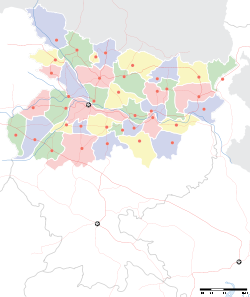
- Narkatiaganj
-
Narkatiaganj — town — Coordinates 27°06′28″N 84°28′38″E / 27.107852°N 84.47709°ECoordinates: 27°06′28″N 84°28′38″E / 27.107852°N 84.47709°E Country India State Bihar District(s) Pashchim Champaran Parliamentary constituency Valmiki Nagar Assembly constituency Narkatiaganj Population 40,830 (2001[update]) Time zone IST (UTC+05:30) Website westchamparan.bih.nic.in/ Narkatiaganj is a city and a notified area in Pashchim Champaran district in the Indian state of Bihar.
Contents
Demographics
As of 2001[update] India census[1], Narkatiaganj had a population of 40,830. Males constitute 54% of the population and females 46%. Narkatiaganj has an average literacy rate of 59%, lower than the national average of 59.5%: male literacy is 68%, and female literacy is 49%. In Narkatiaganj, 17% of the population is under 6 years of age.
Major places of Narkatiaganj
Narkatiaganj Railway junction is a part of north-east railway. It is well connected with major cities of India like Delhi, Mumbai, Kolkata. There are many trains which connect these places to NarkatiaGanj.
Major areas include DEOLIA MADARSA(SHANI FAMILY), SHIVGANJ, Shanti Nagar,Poorani bazar,Shivganj,Naya tola,Prakash Nagar,Marwari Moohalla,Suman Vihar,Professor's Colony,Pokhra Chowk,Alok Vihar,Pandey tola,Hardia Chowk etc.
Educational institutions
TP Verma college is situated at the outer part of the town which has curriculum for graduations and intermediates. High School Narkatiaganj is the biggest school of the town with more than two thousand students. There are two more schools in the town, namely,Railway boys high school and Matisara kunwar girls high school.and new establish H.S.D.A.V school
Places of interest
Narkatiaganj is a subdivision of west champaran, a district of North Bihar. Here, historical "CHANAKI GARH",which is said to be a palace of CHANAKYA in the period of MAURYA Chandragupta, is situated.Very near to Narkatiaganj an "IRON PILLAR" established by King Ashoka is also present, representing the glorios history of India. NEW SWADESHI SUGAR MILLS Ltd,a SUGAR COMPANY of Birla group, is important source of for the economy of this town.various temples such as Birla Mandir,GOPALA BABA Mandir,Satyanarain mandir,and Big mosque represent the religious faith of the people of this town. A river known as Harbora river show the natural beauty. The Main market place is situated very near to the Police station as well as the Railway Station, hence is very crowded. The market showcases a good mix of modern as well as traditional stuff.
For the movie buffs, the town offers three Cinema halls - Himalaya,Bhagwati,Jaishree. Hindi, Bhojpuri films are the main attractions here.
In this town, T.P.Varma College(Bhim Rao Ambedakar University,Muzaffarpur) is the centre for higher studies situated in Gopala Sthan. Nowadays lots of institutions are coming forward for the educational development of this city.A branch of delhi public school &dav also opened in 2009. People of this town are very patriotic and religious[citation needed]. Durga Puja & Chhatth Puja&Sarsvti puja are the main festivals which celebrated in great spirits.
VISHWA MANAV SEWA ASHRAM This is a non for profit voluntary organisation established in Jan1997 and located on the Balore river. Ashram is established on the lands donated by adjoining Sugar Factory and Indian Railways. Ashram follows the simple priniciples of Mahatma Gandhi and works for attaninment of Gram Swarajya. Ashram is working actively for Village Sanitation, self sufficient village producing clothes throght Spinning Wheels, food by hard work & adopting sceintific agricultural practices, Basic and Skills oriented education, social awareness,Legal Literacy, strentheining Panchayati Raj Institution and direct democracy at village level are the parameters which falls under the domain of Gram Swarajya. In the field of education, sanitation and awereness it has gain exemplary achievement.
Ashram is being run by its founder hero Shatrughan Jha, who also works as Assit. Station Master in Indian Railways. He is assisted by a dedicated and committed band of energentic youths. Ashram is operating its activity from three centers namely narkatiagnanj, Bhantadeeh and Cairee. Around 2200 childrens are getting free education covering 22 villages.
References
- ^ "Census of India 2001: Data from the 2001 Census, including cities, villages and towns (Provisional)". Census Commission of India. Archived from the original on 2004-06-16. http://web.archive.org/web/20040616075334/http://www.censusindia.net/results/town.php?stad=A&state5=999. Retrieved 2008-11-01.
Cities and towns in Tirhut Division East Champaran district Muzaffarpur district Sheohar district Sitamarhi district Vaishali district West Champaran district See also Tirhut Division topicsCities and towns
in other DivisionsCategories:- Railway stations in Bihar
- Cities and towns in West Champaran district
- Bihar geography stubs
Wikimedia Foundation. 2010.


