- Crows-an-Wra
-
Coordinates: 50°05′29″N 5°38′36″W / 50.09126°N 5.64343°W
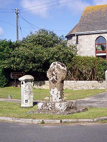 Celtic cross at Crows-an-Wra junction
Crows-an-Wra is a hamlet in west Cornwall, United Kingdom. It is situated in the civil parish of St Buryan approximately four miles (6km) northeast of Land's End[1].
The hamlet consists of a cluster of houses along the A30 road and other more distant dwellings including those at Boscarne.
The name Crows-an-Wra translates from the Cornish as witches crossing and there is evidence that the site was important in neolithic times, including a nearby celtic cross and a holy well. The hamlet once had its own Methodist chapel, but this has since fallen into disuse and has subsequently been converted into housing.
The composer Graham Fitkin was born here.
References
- ^ Ordnance Survey: Landranger map sheet 203 Land's End ISBN 978-0-319-23148-7
External links
 Media related to Crows-an-Wra at Wikimedia Commons
Geography of Cornwall Cornwall Portal Unitary authorities Major settlements Bodmin • Bude • Callington • Camborne • Camelford • Falmouth • Fowey • Hayle • Helston • Launceston • Liskeard • Looe • Lostwithiel • Marazion • Newlyn • Newquay • Padstow • Par • Penryn • Penzance • Porthleven • Redruth • Saltash • St Austell • St Blazey • St Columb Major • St Ives • St Just-in-Penwith • St Mawes • Stratton • Torpoint • Truro • Wadebridge
See also: Civil parishes in CornwallRivers Topics History • Status debate • Flag • Culture • Places • People • The Duchy • Diocese • Politics • Hundreds/shires • Places of interest • full list...Categories:- Villages in Cornwall
- Holy wells
- Cornwall geography stubs

Wikimedia Foundation. 2010.