- New York State Route 248
-
NYS Route 248
Route information Maintained by NYSDOT Length: 31.43 mi[2] (50.58 km) Existed: 1930[1] – present Major junctions West end:  NY 19 in Willing
North end:  NY 36 in Canisteo
Location Counties: Allegany, Steuben Highway system Numbered highways in New York
Interstate • U.S. • N.Y. (former) • Reference • County←  NY 247
NY 249  →
→←  NY 17F
NY 17H  →
→New York State Route 248 (NY 248) is a state highway in a remote part of the Southern Tier region of New York in the United States. The route, located close to the Pennsylvania state line, passes through Allegany and Steuben Counties. In the former, it runs mostly east–west from its junction with NY 19 in Stannards; but in the latter turns northwards to its north end at NY 36 in Canisteo. As a result, NY 248 is signed east–west in Allegany County and north–south in Steuben County.
The origins of NY 248 date back to 1912, when most of the route was designated as an unsigned legislative route by the New York State Legislature. The first posted numbers along the route were assigned as part of the 1930 renumbering of state highways in New York. At this time, NY 248 was assigned to the portion of its modern routing north of Greenwood while the section between NY 19 and NY 417 (then NY 17) was designated as New York State Route 17G. NY 248 was extended southwestward over NY 17G in the early 1940s.
Contents
Route description
Allegany County
NY 248 begins at an intersection with NY 19 in the hamlet of Stannards, located within the town of Willing. It heads generally eastward from the community as Hallsport Road, following Chenunda Creek (a tributary of the Genesee River) into a largely rural portion of the town. Here, the route passes by a series of fields and a handful of isolated homes before leaving the creek and entering Hallsport, a small community near the eastern town line. Past Hallsport, NY 248 follows a more southeasterly routing for just under 1 mile (1.6 km) to the town line, where it turns back to the east as it proceeds into the town of Independence and becomes known only by its route number.[3]
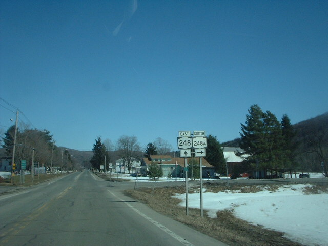
 NY 248 east at NY 248A in Whitesville
About 2 miles (3.2 km) into Independence, the highway makes a sharp curve to the south into a more forested area of Allegany County. At this point, the route begins to descend in elevation as it heads through a small valley surrounding an offshoot of Cryder Creek. Just outside of Whitesville, the small, narrow valley gives way to a wider one surrounding Cryder Creek itself, and NY 248 turns eastward into the latter valley to enter Whitesville as Main Street. In the hamlet, NY 248 intersects its lone spur route, NY 248A, and crosses Cryder Creek, which splits into Marsh and Spring Mills Creeks a short distance to the northeast. At the eastern edge of Whitesville, NY 248 turns northward onto Wildman Avenue, crossing over Spring Mills Creek and following Marsh Creek northeastward out of both Whitesville and Allegany County. The route switches directions from east–west to north–south upon crossing the county line.[3]
Steuben County
Across the county line in Steuben County, NY 248 passes through rural, forested areas as it proceeds northeast along the base of a valley surrounding Marsh Creek. Roughly 2 miles (3.2 km) into the town of West Union, the creek gives way to a large, marshy lake, which NY 248 straddles while proceeding northeastward, and later southeastward through the valley. The valley ends 2 miles (3.2 km) southeast of the hamlet of Barney Falls and 6 miles (10 km) from the county line, allowing the route to turn northward and enter Rexville, a small community based around the junction of NY 248 and County Route 117. Here, NY 248 joins Bennetts Creek, which the route follows for the rest of its existence.[3]
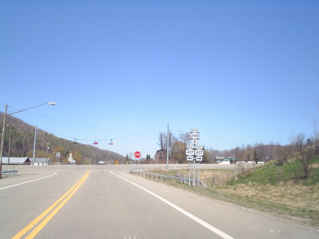
 Junction of NY 248 and NY 417 north of Greenwood hamlet
Outside of Rexville, the route heads north through another forested valley—this time surrounding Bennetts Creek—to the town of Greenwood and the hamlet of the same name, the largest location on the route between Whitesville and the village of Canisteo. NY 248 heads north–south through the community, serving as its main street, before intersecting NY 417 north of the hamlet. The route continues on, passing through sparsely populated areas of the towns of Greenwood and Canisteo as it proceeds along the base of a wider, less pronounced valley around Bennetts Creek. The surroundings change immediately upon crossing over Purdy Creek and into the village of Canisteo, where NY 248 becomes Greenwood Street and passes by the village's schools and several densely populated village blocks. After eight blocks, the street and the route come to an end at Main Street (NY 36).[3]
History
The portion of modern NY 248 east of Whitesville was originally designated as Route 4-b, an unsigned legislative route, by the New York State Legislature in 1912.[4] On March 1, 1921, Route 4-b was renumbered to Route 46 and extended westward along what is now NY 248 and NY 19 to Wellsville.[5] No part of legislative Route 46 was assigned a posted designation when the first set of posted routes in New York were assigned in 1924;[6] however, the entire route received a number as part of the 1930 renumbering of state highways in New York. From Stannards to Greenwood, legislative Route 46 was designated as NY 17G, a southerly alternate route of NY 17 (now NY 417).[7] The section of the route between Stannards and Wellsville became part of NY 19 while the remainder of old Route 46—from Greenwood to Canisteo—became NY 248.[1] NY 17G became part of an extended NY 248 in the early 1940s.[8][9]
NY 248A

NY 248A (5.17 miles or 8.32 kilometres) is a spur connecting NY 248 to the Pennsylvania state line in Allegany County.[2] The route originates at the state line in Willing and continues northeast along the northern edge of a valley surrounding Cryder Creek to Whitesville, where it terminates at NY 248. NY 248A becomes Pennsylvania Route 244 upon entering Pennsylvania.[10] The route was assigned in the early 1950s.[11][12]
Major intersections
County Location Mile[2] Destinations Notes Allegany Willing 0.00 NY 19Hamlet of Stannards Independence 9.37  NY 248A
Hamlet of Whitesville; northern terminus of NY 248A Steuben Greenwood 22.19  NY 417
Village of Canisteo 31.43 NY 361.000 mi = 1.609 km; 1.000 km = 0.621 mi References
- ^ a b Automobile Legal Association (ALA) Automobile Green Book, 1930–31 and 1931–32 editions, (Scarborough Motor Guide Co., Boston, 1930 and 1931). The 1930–31 edition shows New York state routes prior to the 1930 renumbering
- ^ a b c "2008 Traffic Volume Report for New York State" (PDF). New York State Department of Transportation. June 16, 2009. p. 196. https://www.nysdot.gov/divisions/engineering/technical-services/hds-respository/NYSDOT%20TVR%202008%20by%20Route.pdf. Retrieved February 1, 2010.
- ^ a b c d Yahoo! Inc. Yahoo! Maps – overview map of NY 248 (Map). Cartography by NAVTEQ. http://maps.yahoo.com/#mvt=h&lat=42.15396&lon=-77.76365&zoom=12&q1=42.086295%2C-77.921793&q2=42.038005%2C-77.780708&q3=42.142559%2C-77.644753&q4=42.270143%2C-77.6057. Retrieved November 4, 2010.
- ^ New York State Department of Highways (1920). Report of the State Commissioner of Highways. Albany, New York: J. B. Lyon Company. p. 506. http://books.google.com/books?id=Sj4CAAAAYAAJ&pg=PA506. Retrieved November 4, 2010.
- ^ New York State Legislature (1921). "Tables of Laws and Codes Amended or Repealed". Laws of the State of New York passed at the One Hundred and Forty-Fourth Session of the Legislature. Albany, New York: J. B. Lyon Company. pp. 42, 48, 71. http://books.google.com/books?id=6pE4AAAAIAAJ&pg=PA42. Retrieved November 4, 2010.
- ^ "New York's Main Highways Designated by Numbers". The New York Times: p. XX9. December 21, 1924.
- ^ Dickinson, Leon A. (January 12, 1930). "New Signs for State Highways". The New York Times: p. 136.
- ^ Gulf Oil Company (1940). New York Info-Map (Map). Cartography by Rand McNally and Company.
- ^ Esso (1942). New York with Pictorial Guide (Map). Cartography by General Drafting.
- ^ Yahoo! Inc. Yahoo! Maps – overview map of NY 248A (Map). Cartography by NAVTEQ. http://maps.yahoo.com/#mvt=h&lat=42.018105&lon=-77.821875&zoom=14&q1=41.998375%2C-77.863284&q2=42.037911%2C-77.780544. Retrieved November 4, 2010.
- ^ Socony-Vacuum Oil Company (1950). New York (Map). Cartography by Rand McNally and Company.
- ^ Sunoco (1952). New York (Map). Cartography by Rand McNally and Company.
External links
Categories:- State highways in New York
- Transportation in Allegany County, New York
- Transportation in Steuben County, New York


Wikimedia Foundation. 2010.