- Clouds and the Earth's Radiant Energy System
-
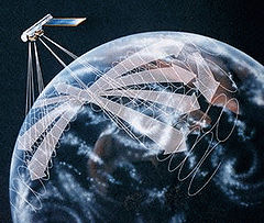 Artist representation of CERES instruments scanning Earth in Rotating Azimuth Plane mode.
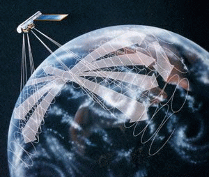
Clouds and the Earth's Radiant Energy System (CERES) is on-going[update] NASA climatological experiment from Earth orbit.[1] The CERES are scientific satellite instruments, part of the NASA's Earth Observing System (EOS), designed to measure both solar-reflected and Earth-emitted radiation from the top of the atmosphere (TOA) to the Earth's surface. Cloud properties are determined using simultaneous measurements by other EOS instruments such as the Moderate Resolution Imaging Spectroradiometer (MODIS).[2] Results from the CERES and other NASA missions, such as the Earth Radiation Budget Experiment (ERBE),[3] will lead to a better understanding of the role of clouds and the energy cycle in global climate change.[4]
Contents
Scientific goals
CERES experiment has four main objectives:
- Continuation of the ERBE record of radiative fluxes at the top of the atmosphere (TOA) for climate change analysis.
- Doubling the accuracy of estimates of radiative fluxes at TOA and the Earth's surface.
- Provide the first long-term global estimates of the radiative fluxes within the Earth's atmosphere.
- Provide cloud property estimates that are consistent with the radiative fluxes from surface to TOA.
CERES instruments
The first CERES instrument (PFM) was launched aboard the NASA Tropical Rainfall Measuring Mission (TRMM) in November 1997 from Japan. An additional four CERES instruments were launched on the EOS Terra satellite in December 1999 (FM1 and FM2) and on EOS Aqua satellite in May 2002 (FM3 and FM4). Currently operational are all CERES instruments on Terra and Aqua satellites. Each CERES instrument is a radiometer which has three channels - a shortwave channel to measure reflected sunlight in 0.3 - 5 µm region, a channel to measure Earth-emitted thermal radiation in the 8-12 µm "window" region, and a total channel to measure entire spectrum of outgoing Earth's radiation. CERES spatial resolution at nadir view (equivalent diameter of the footprint) is 10 km for CERES on TRMM, and 20 km for CERES on Terra and Aqua satellites. Onboard calibration sources include a solar diffuser, a tungsten lamp system with a stability[disambiguation needed
 ] monitor, and a pair of blackbody cavities that can be controlled at different temperatures. Cold space observations and internal calibration are performed during normal Earth scans. During its operation CERES has shown remarkable stability. There has been no discernible change in instrument gain for any channel at the 0.2% level with 95% confidence. Ground and in-space calibrations agree to within 0.25%.
Operating modes
CERES operates in three scanning modes: across the satellite ground track (cross-track), along the direction of the satellite ground track (along-track), and in a Rotating Azimuth Plane (RAP). In RAP mode, the radiometers scan in elevation as they rotate in azimuth, thus acquiring radiance measurement from a wide range of viewing angles. Until February 2005, on Terra and Aqua satellites one of CERES instruments scanned in cross-track mode while the other was in RAP or along-track mode. The instrument operating in RAP scanning mode took two days of along-track data every month. The multi-angular CERES data allowed to derive new models which account for anisotropy of the viewed scene, and allow TOA radiative flux retrieval with enhanced precision.[5]
See also
References
- ^ B.A. Wielicki, et al.; Barkstrom, Bruce R.; Harrison, Edwin F.; Lee Iii, Robert B.; Louis Smith, G.; Cooper, John E. (1996). "Mission to Planet Earth: Role of Clouds and Radiation in Climate". Bull. Amer. Meteorol. Soc. 77 (5): 853–868. Bibcode 1996BAMS...77..853W. doi:10.1175/1520-0477(1996)077<0853:CATERE>2.0.CO;2.
- ^ P. Minnis; et al. (September 2003). "CERES Cloud Property Retrievals from Imager on TRMM, Terra and Aqua". Proceedings of SPIE 10th International Symposium on Remote Sensing. Conference on Remote Sensing of Clouds and the Atmosphere VII. Spain. pp. 37–48.
- ^ B.R. Barkstrom, Bruce R. (1984). "The Earth Radiation Budget Experiment". Bull. Amer. Meteorol. Soc. 65 (11): 1170–1186. Bibcode 1984BAMS...65.1170B. doi:10.1175/1520-0477(1984)065<1170:TERBE>2.0.CO;2.
- ^ B. A. Wielicki, et al.; Harrison, Edwin F.; Cess, Robert D.; King, Michael D.; Randall, David A. (1995). "Mission to Planet Earth: Role of Clouds and Radiation in Climate". Bull. Amer. Meteorol. Soc. 76 (11): 2125–2152. Bibcode 1995BAMS...76.2125W. doi:10.1175/1520-0477(1995)076<2125:MTPERO>2.0.CO;2.
- ^ N. G. Loeb, et al.; Kato, Seiji; Loukachine, Konstantin; Manalo-Smith, Natividad (2005). "Angular distribution models for top-of-atmosphere radiative flux estimation from the Clouds and the Earth's Radiant Energy System instrument on the Terra Satellite. Part I: Methodology". J. Atmos. Ocean. Tech. 22 (4): 338–351. Bibcode 2005JAtOT..22..338L. doi:10.1175/JTECH1712.1.
External links
- NASA CERES official site
- CERES Data Products
- Terra satellite, NASA EOS flagship
- Aqua satallite, NASA EOS
- VISIBLE EARTH, catalog of CERES images
Meteorological remote sensing systems in Earth orbit Concepts Current projects A-train satellitesOther satellitesCBERS · COSMIC (FORMOSAT-3) · COSMO-SkyMed · DMSP · DMC · Elektro-L · Envisat · EROS · ERS · Fengyun · FORMOSAT-2 · GOES · IKONOS · Landsat · MetOp · Meteor · Meteosat · MTSAT · NOAA-N' · QuickBird · RADARSAT-1 · RADARSAT-2 · SMOS · SPOT · TerraSAR-X · THEOSFormer projects CompletedFailedCategories:- NASA programs
- Spacecraft instruments
- Remote sensing
Wikimedia Foundation. 2010.