- Mġarr
-
Mġarr
Il-Kunsill Lokali tal-Imġarr— Local council — L-Imġarr 
Coat of armsCoordinates: 35°55′11″N 14°21′59″E / 35.91972°N 14.36639°ECoordinates: 35°55′11″N 14°21′59″E / 35.91972°N 14.36639°E Country  Malta
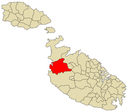
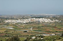
MaltaIsland Malta District Borders Bidnija, Mellieħa, Mosta, Rabat, St. Paul's Bay Government – Mayor Paul Vella (PN) Area – Total 16.1 km2 (6.2 sq mi) Population (Nov 2005) – Total 3,014 – Density 187.2/km2 (484.9/sq mi) Demonym Mġarri (m), Mġarrija (f), Mġarrin (pl) Time zone CET (UTC+1) – Summer (DST) CEST (UTC+2) Postal code MĠR Dialing code 356 Patron saint St. Mary Day of festa 1st Sunday after 15th August Website Official website Mġarr or Imġarr, formerly known as Mgiarro, is a small town in the northwest of the mainland of Malta. Mgarr is a typical rural village situated in an isolated region, west of Mosta. It is surrounded with rich farmland and vineyards. Many of its 3,014[1] inhabitants are farmers or are engaged in some sort of agricultural activity.
Contents
History and development
Mġarr has two important prehistoric sites: Ta' Ħaġrat, which is still in a good state of preservation, stands in a field near the village centre; Ta' Skorba, excavated in 1963, lies just outside the village.
Mġarr's history is that of a farming community patronised by various of the Mdina patrican families. Mgiarro was granted by the King of Sicily to the Inguanez family, and over time they sold it to the Falsone family. Over time, land was split up and given to all descendants.
Mġarr today has grown quite large, though still considered a country town with fresh clean air away from the major industrial towns of Malta.
Mġarr's rustic environs embrace several rustic spots like Binġemma, Wardija, Fomm ir-Riħ, Ghajn Tuffieha and Ġnejna Bay. Mġarr is a favourite stopping place for people strolling in its countryside and for those travelling in cars to the nearby beaches. San Anton School is a private school located within one of Mġarr's scenic valleys.
Church
It was only in the beginning of the 20th century that Mġarr got its own parish and fully completed church. The church is one of the largest dome church in the world, after Mosta. The unique shape, that of an oval dome, is attributed to the extensive funds collected from the sale of locally produced eggs: more than 300,000 were sold in aid of the project.
The parish church of St. Mary (the Assumption) is a miniature copy of the Mosta Rotunda. Its building commenced in 1912 and its construction depended on free labour and on the generous contributions earned by the parishioners from the sale of farm products. Despite all efforts to expedite the work, the building was not completed before 1946.
The church stands on high ground and its elevated terrace offers a charming view of the fertile fields and of the neighbouring hillsides. Several old homesteads still exist in the narrow streets around the church. Modern buildings and a housing estate are new additions to the village.
Mġarr Local Council
The current Mġarr local council members are:
- Vella Paul (Mayor - PN)
- Clayton Gauci (PL)
- Vella Eman (PN)
- Giovann Gatt (PN)
- Maria Said (PL)
Zones in Mġarr
- Abatija
- Ballut
- Binġemma
- Binġemma Gap
- Dar il-Ħamra
- Darrenzi
- Dwejra
- Fawwara
- Fomm ir-Riħ
- Ġnejna Bay
- Għajn Tuffieħa
- Għemieri
- Ħanxara
- Ħotba ta' San Martin
- Iċ-Ċagħaq
- Iċ-Ċarċar
- Id-Dahar
- Il-Għalqa
- L-Imselliet
- L-Iskorvit
- Lippija
- Misraħ Miet
- Ras il-Pellegrin
- Ras il-Wied
- Skorba
- Ta' Mrejnu
- Ta' Tewma
- Ta' l-Għajn
- Ta' Qarawas
- Tal-Faċċol
- Tal-Ħżejjen
- Tal-Palma
- Tal-Qanfud
- Tar-Ragħad
- Tas-Santi
- Wied Santi
- Wied tal-Ġnejna
- Wied ta' l-Imselliet
- Żebbiegħ
Footnotes
- ^ Source: Census of Population and Housing 2005: Preliminary Report. National Statistics Office, Malta, 2006
External links
- http://www.mgarr.gov.mt/ - Mġarr local council
- http://www.lejlamgarrija.com/ - Annual Festival held in Mgarr
Categories:- Towns in Malta
- Local councils of Malta
Wikimedia Foundation. 2010.


