- Mellieħa
-
Mellieħa
Il-Kunsill Lokali tal-Mellieħa— Local council — Il-Mellieħa 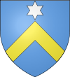
Coat of arms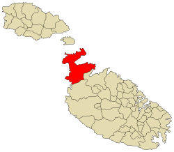
Coordinates: 35°57′23″N 14°21′59″E / 35.95639°N 14.36639°ECoordinates: 35°57′23″N 14°21′59″E / 35.95639°N 14.36639°E Country  Malta
MaltaIsland Malta District Borders St. Paul's Bay, Mġarr Government - Mayor Robert Cutajar (PN) Area - Total 22.6 km2 (8.7 sq mi) Population (Dec 2008 melh u ghase3l_km2 = auto) - Total 7,221 Demonym Mellieħi (m), Mellieħija (f), Mellieħin (pl) Time zone CET (UTC+1) - Summer (DST) CEST (UTC+2) Postal code MLĦ Dialing code 356 Patron saint Our Lady of Victories Day of festa 8th September Website [1] Mellieħa ([məˈliːhə]}, or il-Mellieħa) is a large village (pop. 7,221 in Dec 2008) in the northwestern part of Malta. It is a popular tourist destination during the summer months. Mellieħa as a village developed under British colonization after the British encouraged people to settle in the area by giving leases to the population. For two centuries previously, the area was abandoned due to fear from attacks of corsairs and Saracens. Before that, only a few villagers lived in the area.
Contents
European Destinations of Excellence: 2009
The locality of Mellieħa has through its sustainable initiatives succeeded in achieving the 2009 title of excellence.
Locales
- Mellieha Sports Club
- Ghaqda tar-Residenti ta' Santa Marija Estate, Mellieha
- La Vittoria Band Club
- Imperial Band Club
Mellieħa main roads
- Dawret il-Mellieħa (Mellieħa By-Pass)
- Triq Ġorġ Borg Olivier (Ġorġ Borg Olivier Street)
- Triq il-Kbira (Main Street)
- Triq il-Marfa (Marfa Road)
- Triq il-Prajjiet (Anchor Bay Road)
- Triq Louis Wettinger (Louis Wettinger Street)
- Triq San Pawl il-Baħar (St. Paul's Bay Road)
External links
- Mellieħa Local Council official web site
- Mellieħa.info - Information site
- Mellieħa.com - Commercial & Information site
- Awarded "EDEN - European Destinations of Excellence" non traditional tourist destination 2009
Categories:- Towns in Malta
- Local councils of Malta


Wikimedia Foundation. 2010.