- Malta Island
-
Malta 
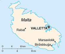
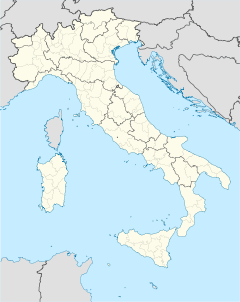
Map of Malta IslandGeography Location south of Sicily, Mediterranean Sea Archipelago Maltese islands Area 246 km2 (95 sq mi) Coastline 197 km (122.4 mi) Highest elevation 253 m (830 ft) Highest point Ta'Dmejrek Country MaltaLargest city Birkirkara Demographics Population 388,232 (as of 2007) Density 1,578.18 /km2 (4,087.47 /sq mi) Ethnic groups Maltese people Malta Island is the largest of the three major islands that constitute the Maltese archipelago and Republic of Malta. Malta is in the middle of the Mediterranean Sea directly south of Italy and north of Libya. The area is 246 km² (95 square miles). The capital is Valletta, largest city is Qormi and the largest locality is Birkirkara. The island is made up of many small towns, which together form one Larger Urban Zone (LUZ) with a population of 368,250 (the majority of the population of the country) according to Eurostat.[1] The landscape is characterised by low hills with terraced fields.
Notes
See also
- Geography of Malta
- Gozo Island
- Comino
External links
Malta Island (Malta) · Gozo (Għawdex) · Comino (Kemmuna) · Cominotto (Kemmunett) · Delimara Island (Sikka ta' Delimara) · Filfla (Filfla) · St Paul's Island (Il-Gżejjer ta' San Pawl) · Manoel Island (Il-Gżira Manwel) · Fungus Rock (Il-Ġebla tal-Ġeneral)
 Categories:
- Malta geography stubs
- Islands of Malta
Wikimedia Foundation. 2010.


