- North Coast Harbor
-
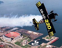
North Coast Harbor is a district in downtown Cleveland, Ohio on the shore of Lake Erie. It includes the Great Lakes Science Center, the Rock and Roll Hall of Fame, Cleveland Browns Stadium, the Steamship William G. Mather Maritime Museum, the USS Cod, Burke Lakefront Airport, the Lake Shore Electric Railway interurban museum, Voinovich Park, and the Cleveland-Cuyahoga County Port Authority. It is served by the West 3rd and North Coast stations on RTA's light rail Waterfront Line.
Contents
Events
The harbor was the site of the Great Lakes Exposition, a historic event starting in 1936 that commemorated the centennial of Cleveland's incorporation as a city. In the summers of 2007 and 2008, the harbor hosted the AST Dew Tour's Right Guard Open.
Development
The Cleveland Browns are spearheading development plans to construct an entertainment and commercial district in the area behind Cleveland Browns Stadium and the Great Lakes Science Center.
Randy Learner, the owner of The Browns stated: “This is a unique opportunity for Cleveland to come together. We think the time has come to make the Lakefront a more dynamic and inviting area. We are very pleased to help with this concept, and we hope our interest attracts other private sector development geared toward making the Lakefront what it could and should be for the Cleveland community.” [1]
References
External links
City of Cleveland City Council · Historic Places · History · Mayors · Media · People · Police · Public schools · Sports · Tallest buildings Neighborhoods Brooklyn Centre · Buckeye-Shaker · Central · Clark-Fulton · Corlett · Cudell · Detroit-Shoreway · Downtown · Edgewater · Euclid-Green · Goodrich-Kirtland Park · Fairfax · Forest Hills · Glenville · Hough · Industrial Valley · Jefferson · Kamm's Corners · Kinsman · Lee-Miles · Mt. Pleasant · North Broadway · North Collinwood · Ohio City · Old Brooklyn · Puritas-Longmead · Riverside · South Broadway · South Collinwood · St. Clair-Superior · Stockyards · Tremont · Union-Miles Park · University · West Boulevard · Woodland HillsCoordinates: 41°30′30″N 81°41′47″W / 41.50833°N 81.69639°W
Categories:- Geography of Cleveland, Ohio
- Redeveloped ports and waterfronts
- Northeastern Ohio geography stubs
Wikimedia Foundation. 2010.

