- Detroit-Shoreway
-
Detroit-Shoreway — Neighborhoods of Cleveland — Cleveland Public Theater, near the intersection of W.65th and Detroit Ave.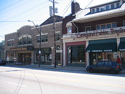
Country United States State Ohio County Cuyahoga County City Cleveland Population (2000) - Total 17,382 6.5% decrease from 1990 Census Demographics - White 63.4% - Black 17.9% - Hispanic 24% - Asian 1.1% - Other 12.1% Time zone EST (UTC-5) - Summer (DST) EDT (UTC-4) ZIP Codes 44102 Area code(s) 216 Median income $21,319 Source: 2000 U.S. Census, City Planning Commission of Cleveland [1] Detroit-Shoreway is a neighborhood on Cleveland's West Side. Detroit-Shoreway consists of the streets between Lake Erie and Interstate 90, from West 85th to West 45th streets.[2]
Contents
Gordon Square
 Gordon Square, Detroit-Shoreway's retail hub and slated to become an arts area in the near future.
The retail hub of Detroit-Shoreway is Gordon Square, a series of retail buildings on the four corners of Detroit Avenue and West 65th Street. Named for W.J. Gordon, considered a "city father"[2], Gordon Square is currently the central focus of efforts to remake Detroit-Shoreway into a cultural and artistic hub for the west side, including the renovation and re-opening of the movie theater, a new building for the Near West Theatre, and renovations to the Cleveland Public Theater complex,[3] as well as a complete rebuild of the Detroit Avenue streetscape from West 58th to West 73rd streets, including burying of utility lines.[4] Additional plans include rebuilding the Lorain Avenue streetscape within the Lorain Avenue Antiques District, from West 52nd to West 82nd.[4]
New developments
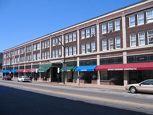
Detroit-Shoreway is serviced by various bus routes, and includes its own rapid transit station, West 65th-Lorain. The Greater Cleveland Regional Transit Authority, in conjunction with the City of Cleveland and the Cleveland EcoVillage, is working on plans for transit-oriented development in the area around the station, and Detroit-Shoreway is additionally the site of a brownfield redevelopment of an old Eveready Battery Plant, known as Battery Park.[5] The city is working with the Ohio Department of Transportation on plans to rebuild the limited access West Shoreway (SR-2) as a low-speed, 35 mph boulevard, reconnecting the long-split neighborhood with access to the lake.[6]
References
- ^ http://planning.city.cleveland.oh.us/census/factsheets/spa08.pdf
- ^ a b Neighborhood Link: Detroit Shoreway History, Cleveland State University. Accessed 2007-07-26.
- ^ Gordon Square Cultural Arts District, Detroit-Shoreway Neighborhood Development Organization. Accessed 2007-07-26.
- ^ a b Detroit-Shoreway Neighborhood Plan Summary Cleveland City Planning Commission. Accessed 2007-07-26.
- ^ Battery Park. Accessed 2007-07-26.
- ^ Cleveland Lakefront West, Cleveland Urban Core Projects, Ohio Department of Transportation. Accessed 2007-07-26.
External links
City of Cleveland City Council · Historic Places · History · Timeline · Mayors · Media · People · Police · Public schools · Sports · Tallest buildings Neighborhoods Brooklyn Centre · Buckeye-Shaker · Central · Clark-Fulton · Corlett · Cudell · Detroit-Shoreway · Downtown · Edgewater · Euclid-Green · Goodrich-Kirtland Park · Fairfax · Forest Hills · Glenville · Hough · Industrial Valley · Jefferson · Kamm's Corners · Kinsman · Lee-Miles · Mt. Pleasant · North Broadway · North Collinwood · Ohio City · Old Brooklyn · Puritas-Longmead · Riverside · South Broadway · South Collinwood · St. Clair-Superior · Stockyards · Tremont · Union-Miles Park · University · West Boulevard · Woodland Hills
Edgewater Lake Erie Cudell 
Ohio City  Detroit-Shoreway

West Boulevard Stockyards Clark-Fulton Coordinates: 41°28′45″N 81°44′16″W / 41.479062°N 81.737795°W
Categories:- Neighborhoods in Cleveland, Ohio


Wikimedia Foundation. 2010.