- Marchington Woodlands
-
Coordinates: 52°51′39″N 1°49′52″W / 52.8609°N 1.8311°W
Marchington Woodlands 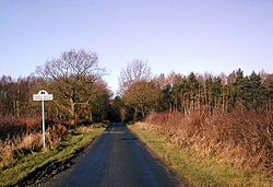
One of the Roads into Marchington Woodlands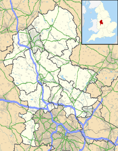
 Marchington Woodlands
Marchington Woodlands shown within StaffordshirePopulation 250 (2001) OS grid reference SK1029 Parish Marchington District East Staffordshire Shire county Staffordshire Region West Midlands Country England Sovereign state United Kingdom Post town Uttoxeter Postcode district ST14 Dialling code 01889, 01283 Police Staffordshire Fire Staffordshire Ambulance West Midlands EU Parliament West Midlands UK Parliament Burton List of places: UK • England • Staffordshire Marchington Woodlands is a small village near Uttoxeter in Staffordshire,. It has a church and a village hall. The local first school was closed in the 1990s and the building was converted into a private home. Marchington Woodlands consists mostly of farms and cottages. it is often Referred to by locals as The Woodlands.
Contents
History
Marchington Woodlands became a village in 1859 with the opening of the Parish church.
Demographics
According to the 2001 census for the 41UCGK0008 (Output Area), the population for Marchington Woodlands is 252 people, The area has 122 males and 130 females.[1] The area is 100% white and over 97% White British with only 6 people from an ethnic minority.[2]
Governance
Marchington Woodlands is part of the Marchington Civil parish.
Marchington Woodlands is part of the Crown ward in East Staffordshire and is represented by the Conservative Charles Hardwick. And the Dove ward in Staffordshire County council and is represented by Bob Fraser who is also Conservative.
Marchington Woodlands is part of the Burton constituency and is represented by the Conservative Andrew Griffiths. In Europe it is part of the West Midlands constituency and is represented by 6 MEPs.
Geography
Marchington Woodlands is set out and its spread out of an area of around 3 miles. There are 2 areas called Scounslow Green and Gorsty Hill. The area around Marchington Woodlands is Hilly and there are several forests.
Climate
Climate data for Staffordshire (1971–2000 averages) Month Jan Feb Mar Apr May Jun Jul Aug Sep Oct Nov Dec Year Average high °C (°F) 6.5
(43.7)6.9
(44.4)9.5
(49.1)12
(54)15.7
(60.3)18.4
(65.1)21.1
(70.0)20.8
(69.4)17.5
(63.5)13.5
(56.3)9.5
(49.1)7.5
(45.5)13.3 Average low °C (°F) 1
(34)1
(34)2.5
(36.5)3.5
(38.3)6.2
(43.2)8.9
(48.0)11.1
(52.0)10.9
(51.6)9
(48)6.4
(43.5)3.3
(37.9)1.8
(35.2)5.5 Rainfall mm (inches) 62.7
(2.469)44.4
(1.748)51.2
(2.016)48.5
(1.909)52.7
(2.075)59.3
(2.335)46.7
(1.839)57.7
(2.272)63.6
(2.504)60.5
(2.382)62
(2.44)66.8
(2.63)676
(26.61)Source: [1] Public Services
Waste collection services are provided by East Staffordshire Borough Council. Water and sewage services are provided by South Staffordshire Water and the Sewage Treatment Works is in Uttoxeter. The Distribution Network Operator for electricity is Central Networks better known as E.ON UK.
Marchington Woodlands uses an Stoke-On-Trent (ST) postcode and the Postal Town is Uttoxeter. The nearest Library is located in Uttoxeter.
Marchington Woodlands uses two telephone area codes, Burton upon Trent (01283) and Uttoxeter (01889).
The nearest police and fire stations are in Uttoxeter.
Health
The village lies in the South Staffordshire NHS trust area. The village does not have its own doctor's surgery or pharmacy The nearest GP's surgeries can be found in Uttoxeter.[3] The Queens Hospital at Burton-upon-Trent is the area's local hospital.[4] It has an Accident and Emergency Department.
Crime
In 2009 there was an average of 2.9 crimes per 1,000 people for the Bagot and Marchington Neighbourhood area. In 2010 the figure was down to 2.5 crimes per head. The most common type of crime is anti-social or Burglary behaviour.[5] in January 2011 there were no reported crimes in Marchington Woodlands.
Religion
Marchington Woodlands Lies in the Anglican parish of Marchington Woodlands and the Roman Catholic parish of St Mary, Uttoxeter. In 2001 89% described themselves as Christian and 11% described themselves as Not-Religious.
St. John's church, Marchington Woodlands
Main article: St. John's church, Marchington WoodlandsThe only place of Worship in Marchington Woodlands is St. John's church, which is a Church of England parish church.
Education
Marchington Woodlands uses the Uttoxeter Middle school system
There was previously a primary school that closed in the 1990s. Now students attend the primary school in Marchington. After students attend Oldfields Hall Middle School and then Thomas Alleyne's High School both of which are in Uttoxeter.
There is also a Private Preparatory school called Smallwood Manor which is a feeder school to Denstone College.
Transport
There are no bus routes and all roads serving the village are single track roads.
The nearest bus routes are in Birch Cross. The nearest Railway station is Uttoxeter.
The Nearest airports are East Midlands (21 Miles) and Birmingham (29 Miles).
Media
The local Newspapers covering the area are The Uttoxeter advertiser and The Uttoxeter Post and Times also on a wider area scale there is The Sentinel from Stoke-On-Trent and Burton Mail from Burton-On-Trent
Marchington Woodlands Receives both BBC West Midlands and BBC East Midlands plus ITV Central television. Local radio stations in the area are BBC Radio Derby, BBC Radio Stoke, Touch, Signal 1 and Capital East Midlands.
References
External links
 Media related to Marchington Woodlands at Wikimedia CommonsCategories:
- Villages in Staffordshire
- East Staffordshire


Wikimedia Foundation. 2010.