- Chañaral
-
Chañaral — City and Commune — Plaza Chañaral Map of Chañaral commune in the Atacama Region
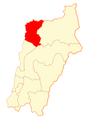 Location in Chile
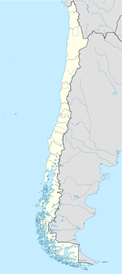
 Chañaral
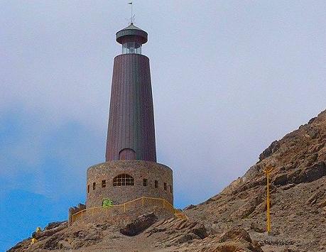
Coordinates: 29°2′0″S 71°26′0″W / 29.033333°S 71.433333°WCoordinates: 29°2′0″S 71°26′0″W / 29.033333°S 71.433333°W Country Chile Region Atacama Region Province Chañaral Province Government[1] – Type Municipality – Alcalde Area[2] – Total 5,722.4 km2 (2,209.4 sq mi) Population (2002 Census)[2] – Total 13,543 – Density 2.4/km2 (6.1/sq mi) – Urban 13,180 – Rural 363 Sex[2] – Men 6,968 – Women 6,575 Time zone CLT (UTC−4) – Summer (DST) CLST (UTC−3) Area code(s) 56 + 52 Website Municipality of Chañaral Chañaral is a small coastal city and commune in the Atacama Region, Chile and capital of the Chañaral Province. A colourful town largely unknown by tourists, who generally head straight for towns such as San Pedro de Atacama. The town is considered unspoiled, with the benefit of having absolutely no high rise buildings. On the arid hills nearby is a lighthouse which casts a beam over the town during the night. Throughout the day and night, there is a lively, bustling atmosphere on the narrow streets. Despite it being coastal, it is not a typical seaside resort, partly because the ocean is contaminated by copper mining industry.[3][4][5] Situated a short distance to the north is the Pan de Azúcar National Park.
Contents
History
In 1824, Diego de Almeyda made the discovery of the large natural deposits of copper in the area, and was the first in the mining industry in Chile to export it. For this reason, the town was founded October 26, 1833 as Chañaral de las Ánimas ("Chañaral of the Souls"). A few of years later, Pedro Lujan discovered ore at El Salado, where a mine was built. In 1836, a shipping port promising raw material was constructed. The great boom Chañaral began in 1860 when A. Edwards & Company was inaugurated where an inn exists today.
Demographics
According to the 2002 census by the National Statistics Institute (INE) the commune of Chañaral spans an area of 5,772.4 km2 (2,229 sq mi) and had 13,543 inhabitants (6,968 men and 6,575 women). Of these, 13,180 (97.3%) lived in urban areas and 363 (2.7%) in rural areas. The population fell by 2.8% (393 persons) between the 1992 and 2002 censuses.[2] The demonym for a person from Chañaral is Chañaralino for a man and Chañaralina for a woman.
Administration
As a commune, Chañaral is a third-level administrative division of Chile administered by a municipal council, headed by an alcalde who is directly elected every four years. The 2008-2012 alcalde is Hector Volta Rojas (PRSD), and the council has the following members:[1]
- Carmen Rojas Cornejo (RN)
- Isabel Ogalde Álvarez (PS)
- Margarita Flores Salazar (PRSD)
- Mary Álamos Gutiérrez (PDC)
- Mery Schampke Galleguillos (PPD)
- Omar Monroy López (PRI)
Within the electoral divisions of Chile, Chañaral is represented in the Chamber of Deputies by Lautaro Carmona (PC) and Carlos Vilches (UDI) as part of the 5th electoral district, (together with Diego de Almagro and Copiapó). The commune is represented in the Senate by Isabel Allende Bussi (PS) and Baldo Prokurica Prokurica (RN) as part of the 3rd senatorial constituency (Atacama).

References
- ^ a b (Spanish) "Municipality of Chañaral". http://www.munichanaral.cl/. Retrieved 2 September 2010.
- ^ a b c d (Spanish) "National Statistics Institute". http://www.ine.cl/canales/chile_estadistico/censos_poblacion_vivienda/censo_pobl_vivi.php. Retrieved 8 September 2010.
- ^ J.C. Castilla (1983). "Environmental impact in sandy beaches of copper mine tailings at Chañaral, Chile". Marine Pollution Bulletin (Elsevier Ltd.) 14 (12): 459–464. doi:10.1016/0025-326X(83)90046-2.
- ^ J.A. Vasquez, B. Matsuhiro, M.A. Vega, L.M. Pardo, D. Veliz (2000). "The effects of mining pollution on subtidal habitats of northern Chile". International Journal of Environment and Pollution 13 (1–6): 2–25. doi:10.1504/IJEP.2000.002330. http://inderscience.metapress.com/link.asp?id=7vnabq9t8xuvnmwp.
- ^ J.L. Stauber, S. Andrade, M. Ramirez, M. Adams and J.A. Correa (2005). "Copper bioavailability in a coastal environment of Northern Chile: Comparison of bioassay and analytical speciation approaches". Marine Pollution Bulletin (Elsevier Ltd.) 50 (11): 1363–1372. doi:10.1016/j.marpolbul.2005.05.008. PMID 15993430.
External links
- (Spanish) Municipality of Chañaral
< Communes and municipalities in Atacama Region > Chañaral Province 
Copiapó Province Huasco Province Categories:- Communes of Chile
- Port settlements in Chile
- Populated places established in 1833
- Populated places in Chañaral Province
- Capitals of Chilean provinces


Wikimedia Foundation. 2010.