- Croftfoot railway station
-
Croftfoot 
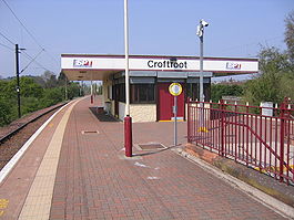
Croftfoot railway station, looking west Location Place Glasgow & Rutherglen Local authority Glasgow & South Lanarkshire Coordinates 55°49′05″N 4°13′41″W / 55.818°N 4.228°WCoordinates: 55°49′05″N 4°13′41″W / 55.818°N 4.228°W Operations Station code CFF Managed by First ScotRail Number of platforms 2 Live arrivals/departures and station information
from National Rail EnquiriesAnnual rail passenger usage 2004/05 * 120,186 2005/06 * 139,821 2006/07 * 155,627 2007/08 * 161,982 2008/09 * 0.179 million National Rail - UK railway stations A B C D E F G H I J K L M N O P Q R S T U V W X Y Z * Annual passenger usage based on sales of tickets in stated financial year(s) which end or originate at Croftfoot from Office of Rail Regulation statistics. Please note: methodology may vary year on year. Croftfoot railway station is a railway station that lies directly on the City of Glasgow / South Lanarkshire boundary (the western part in Glasgow and the eastern part being in South Lanarkshire) serving the Croftfoot area of the City of Glasgow and the Spittle area of the town of Rutherglen, Scotland. The station is managed by First ScotRail and is on the Newton branch of the Cathcart Circle Line.
Preceding station  National Rail
Following station Burnside First ScotRail
King's Park References
Categories:- Railway stations in Glasgow
- Former London Midland and Scottish Railway stations
- Railway stations opened in 1931
- SPT railway stations
- Railway stations served by First ScotRail
- Scotland railway station stubs
Wikimedia Foundation. 2010.
