- Convention Center District, Dallas, Texas
-
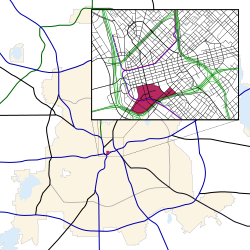
Convention Center District Location in Dallas Country United States State Texas Counties Dallas City Dallas Area Downtown Elevation 410 ft (125 m) ZIP code 75202 Area code(s) 214, 469, 972 The Convention Center District is an area in southern downtown Dallas, Texas (USA). It lies south of the Government District, north of the Cedars, west of the Farmers Market District, and east of the Reunion District.
Contents
Attractions
- Dallas Convention Center
- Pioneer Plaza
- Pioneer Park Cemetery
Transportation
Highways
 - Interstate 30
 - Interstate 35E
Trains
Education
The district is zoned to schools in the Dallas Independent School District.
Residents of the district are zoned to City Park Elementary School, Billy Earl Dade Middle School, and James Madison High School.[1]
References
- ^ Dallas ISD - 2006 School Feeder Patterns - James Madison High School. (Maps: ES: City Park; MS: Dade; HS: Madison.) Retrieved 31 December 2006.
External links
Districts of downtown Dallas Neighborhoods in Dallas Downtown Arts District | City Center District | Convention Center District | Farmers Market District | Government District | Main Street District | Reunion District | West End Historic DistrictEast Dallas Belmont | Bryan Place | Casa Linda Estates | Casa View | Deep Ellum | Eastwood | Forest Hills | Greenland Hills (M Streets) | Hollywood Heights | Lake Park Estates | Lakewood | Lakewood Heights | Little Forest Hills | Lower Greenville | Lochwood | Old Lake Highlands | Parkdale Heights | Ridgewood Park | Santa Monica | Wilshire Heights
Old East Dallas: Junius Heights | Munger Place Historic District | Peak's Suburban Addition | Swiss AvenueLake Highlands Abrams Place | Alexander's Village | Boundbrook Oaks Estates | Chimney Hill | Copperfield Community | Country Forest | Forest Highlands | Forest Meadow | Glen Oaks | Hamilton Park | Highlands West | Highland Meadows | High Oaks Addition | Jackson Meadow | L Streets | Lake Highlands Estates | Lake Highlands North | Lake Highlands Square | Lake Ridge Estates | Merriman Park/University Manor | Merriman Park North | Moss Farm | Moss Meadows | Northwood Heights | Oak Highlands | Oak Tree Village | Pebble Creek | Richland Park Estates | Rolling Trails | Royal Highlands | Royal Highlands Village | Stultz Road | Town Creek | Royal Lane Village | Walnut Creek Estates | Whispering Hills | White Rock Valley | Woodbridge | Woodlands on the Creek | University Terrace | Urban ReserveNorth Dallas Bluff View | Devonshire | Greenway Parks | Melshire Estates | Northwood Hills | Platinum Corridor | Preston Center | Preston Hollow | Telecom Corridor (Richardson) | Vickery Meadow | Vickery Place
Far North Dallas: Bent Tree | Preston Highlands | Renner | TimberglenNorthwest Dallas Oak Cliff Arcadia Park | Bishop Arts District | East Kessler Park | Highland Hills | Kidd Springs | Kessler Highlands | Kessler Neighbors United| Kessler Park Estates | Kessler Plaza | Kessler Square | Kings Highway Conservation District | Lake Cliff | L.O. Daniel | Redbird | Stevens Park Estates | Stevens Park Village | West Kessler | Western Park | Winnetka Heights | WynnewoodOak Lawn Cityplace | International Center | Knox Park | LoMac | Perry Heights | State Thomas | Turtle Creek | Uptown | Victory Park | West VillagePleasant Grove South Dallas West Dallas Eagle Ford | La Bajada | La L'aceate | La Loma | Lake West | Ledbetter Gardens | Los Altos | Muncie | Western Heights | Westmoreland HeightsCity of Dallas History · Government · Demographics · Economy · Transportation ·
Geology · Culture · Sports · Neighborhoods · Architecture · EducationCategories:- Neighborhoods in Downtown Dallas, Texas
- Dallas, Texas stubs
- Dallas County, Texas geography stubs
Wikimedia Foundation. 2010.


