- Ishinomaki, Miyagi
-
Ishinomaki City
石巻市— City — 
FlagLocation of Ishinomaki City in Miyagi Prefecture

 Ishinomaki City
Coordinates: 38°25′N 141°18′E / 38.417°N 141.3°ECoordinates: 38°25′N 141°18′E / 38.417°N 141.3°E Country Japan Region Tōhoku Prefecture Miyagi Prefecture Government – Mayor Hiroshi Kameyama Area – Total 555.36 km2 (214.4 sq mi) Population (January 1, 2010) – Total 164,294 – Density 295.83/km2 (766.2/sq mi) Time zone Japan Standard Time (UTC+9) City symbols - Tree Japanese Black Pine - Flower Azalea Phone number 0225-95-1111 Address 14-1 Kokucho,
Ishinomaki-shi, Miyagi-ken
986-8501Website www.city.ishinomaki.lg.jp Ishinomaki (石巻市 Ishinomaki-shi) is a city located in Miyagi Prefecture, Japan.
As of January 1, 2010, the city had an estimated population of 164,294 and a population density of 295.83 persons per km². The total area is 555.35 km².
A rice-shipping port founded in the 4th century, Ishinomaki is known for its large fish market, a museum devoted to manga, and a replica of the Statue of Liberty on a small island in the Old Kitakami River.[citation needed]
Contents
History
The city was founded on April 1, 1933.
On April 1, 2005, Ishinomaki was merged with six towns, Kahoku, Kanan, Kitakami, Monou and Ogatsu, all from the former Monou District, and Oshika, from Oshika District, to more than quadruple its area and add nearly 60,000 people to its population.
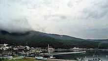 Ogatsu
The town of Ogatsu is regionally famous for its inkstones and has an annual scallop festival in the summer. The city was a base for several ships in Japan's whaling fleet.
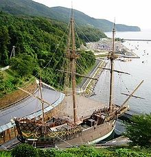
The city also hosts a full-size replica of the Japanese warship San Juan Bautista, a ship commissioned in 1613 by Date Masamune, Daimyo of Sendai, to transport an embassy to the Pope in Rome.
Ishinomaki Station area roughly corresponds to Manga Road, along with Ishinomori Manga Museum in town are celebrating Shotaro Ishinomori's manga legacy.
Ishinomaki includes Tashirojima (aka Manga Island), Ajishima, and Kinkasan, three islands off the south coast of Oshika Peninsula.
2011 earthquake, tsunami, and subsidence
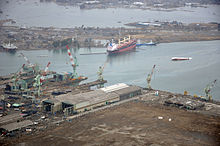 Ishinomaki port on 20 March 2011 showing heavy damage to ships and port facilities caused by the 11 March 2011 tsunami
The city was among the most seriously affected by the 2011 Tōhoku earthquake and tsunami.[1][2] A tsunami about 10 meters high traveled 600 meters inland and destroyed around 80% of the 700 houses in the coastal whaling port of Ayukawa and district of Kadonowaki.[3][4] Approximately 46% of the city was inundated by the tsunami.[5]
One elementary school, Okawa Elementary, was completely destroyed, killing 75 of 108 students and 10 of 13 teachers and staff. The teachers and students were evacuating from the school and were swept away bey the tsunami while crossing a nearby river bridge. One of the teachers who survived later committed suicide.[6][7][8][9]
As of 17 June 2011[update], a total of 3,097 deaths had been confirmed in Ishinomaki due to the tsunami, with 2,770 unaccounted for.[10] Approximately 29,000 city residents lost their homes.[11]
The earthquake shifted the city southeast and downward, lowering it by as much as 1.2 m in some areas and causing it to flood twice daily at high tide.[12]
International friendship links
 Civitavecchia, Lazio, Italy
 Wenzhou, Zhejiang, China
 Port of Everett: Everett, Washington (State), United States
Japanese sister cities
Education
Ishinomaki Okawa Elementary School (大川小学校) was one of the schools worst affected by the Tōhoku earthquake and tsunami of March 11, 2011. When the earthquake occurred, the staff and students evacuated the school, but were hit by the subsequent tsunami. Of the 108 registered students, 77 are missing or presumed to be dead.[13]
Transportation
Railway stations
- JR East: The central station is Ishinomaki Station.
Intercity bus
Daily scheduled intercity buses bound for the following cities on the Sanriku Expressway are served from Ishinomaki Station.
- Sendai via Aeon Ishinomaki Shopping Center (Mall), by Miyakou Bus Co. Ltd., a subsidiary of Miyagi Transportation (Miyagi Kotsu) Co., Ltd.
- Shinjuku, Tokyo via Shibuya(overnight): via Sendai, operated by Miyagi Transportation (Miyagi Kotsu) Co., Ltd. and Keio Dentetsu Bus Corporation
Major roads
- Sanriku Expressway (Ishinomaki-kanan, Kahoku, Monou-toyosato and Monou-tsuyama interchanges)
- National Road Route 45, Route 108, Route 398
See also
External links
 Media related to Ishinomaki, Miyagi at Wikimedia Commons
- Official website (Japanese)
- Official website in English
References
- ^ Satellite Photos of Japan Before and After the Quake and Tsunami New York Times, 13 March 2011
- ^ Kyodo News, "Death toll may surpass 10,000 in Miyagi", Japan Times, 14 March 2011, p. 1.
- ^ Kyodo News, "Miyagi coastal whaling port pulverized, little more than memory", Japan Times, 18 March 2011, p. 3.
- ^ Gihooly, Rob, "'Nothing can prepare you to witness this', Japan Times, 20 March 2011, p. 7.
- ^ NHK, "Tsunami flooded 100 square kilometers of city land", 29 March 2011.
- ^ Gilhooly, Rob, "Parents unable to let go continue search for missing kids", Japan Times, 13 October 2011, p. 3.
- ^ Associated Press, "Loss-staggered school reopens", Japan Times, 19 April 2011, p. 3.
- ^ Kyodo News, "Loss-hit Ishinomaki school opens", Japan Times, 22 April 2011, p. 2.
- ^ Kyodo News, "School that lost 70% of its pupils mourns", Japan Times, 29 April 2011, p. 1.
- ^ Kyodo News, "Ishinomaki can't tally March 11 missing", Japan Times, 17 June 2011, p. 2.
- ^ Robson, Seth, "Ishinomaki residents rebuild their lives as they rebuild their town", Stars and Stripes, 30 August 2011.
- ^ Alabaster, Jay (May 9, 2011). "Quake shifted Japan; towns now flood at high tide". Contra Costa Times/Associated Press. http://www.contracostatimes.com/california/ci_18026656?nclick_check=1. Retrieved May 9, 2011.
- ^ Lah, Kyung. "In Japan, parents try to go on: 'My child should come home to me'." CNN. March 23, 2011. Retrieved on March 23, 2011.
 Miyagi Prefecture
Sendai (capital) Other cities Districts See also: Towns and villages by districtCategories:- Cities in Miyagi Prefecture
- Port settlements in Japan
- Populated coastal places in Japan
- Cities and towns devastated by the 2011 Tōhoku earthquake and tsunami
- Populated places established in 1933


Wikimedia Foundation. 2010.