- Kesennuma, Miyagi
Japanese city| Name = Kesennuma City
JapaneseName = 気仙沼市| Region = Tōhoku
Prefecture =Miyagi Prefecture
Area_km2 = 225.81 | Population = 67,272
PopDate = 2005
Density_km2 = 298
Mayor = Noboru Suzuki
Coords=
LatitudeDegrees= 38
LatitudeMinutes= 53
LatitudeSeconds=
LongtitudeDegrees= 141
LongtitudeMinutes= 35
LongtitudeSeconds=
Tree =Japanese Black Pine
Flower =Azalea
Bird =Seagull
Symbol
CityHallAddress=Kesennuma-shi,
Yōka-machi 1, Chome 1-1
CityHallPhone=0226-22-6600
CityHallLink = [http://www.city.kesennuma.miyagi.jp/ www.city.kesennuma.miyagi.jp] | City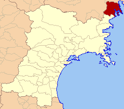
Kesennuma (気仙沼市; -shi) is a city located in the extreme northeast of
Miyagi Prefecture . It wraps around the western part of Kesennuma Bay, and also includes the island of Ōshima. Its coastline forms the southern boundary of the Rias Coastline National Park, which stretches north all the way toAomori Prefecture .The city borders Hirota Bay, Kesennuma Bay, and the
Pacific Ocean to the east andMotoyoshi, Miyagi to the south.Iwate Prefecture makes up the remainder of its borders, with Murone Village to the west, and Rikuzen-Takata City to the north.The highest point in Kesennuma is 711.9 m high, on the border with Motoyoshi, while the lowest point is at sea level.
The city was founded on
June 1 ,1953 .History
*
June 1 ,1953 : Kesennuma Town, Shishiori Village, and Matsuiwa Village merge to incorporate as Kesennuma City.
*April 1 ,1955 : Niitsuki Village, Hashikami Village, and Oshima Village are annexed.
*March 31 ,2006 : Karakuwa Town is annexed.*A planned merger of municipalities will be implemented on
September 1 ,2009 ; Motoyoshi in Motoyoshi District will merge into Kesennuma.http://www.kokudo.or.jp/new/cities/sub/tohoku/04.htm]Climate
Kesennuma is situated in a
temperate climate zone and has a moderate climate. The city's average temperature is 10.8°C (53.8°F) and its average annual precipitation is 1,370.6 mm. Its all-time record high is 36.0°C onAugust 15 ,1994 , and its all-time record low is -12.6°C onFebruary 17 ,1980 . The city's climate is fairly similar to Sendai, the largest city inMiyagi Prefecture . Since Kesennuma is located north of Sendai, it is naturally slightly cooler. However, Kesennuma is known to be fairly warm for a city located at its latitude, largely because ofocean currents that flow close by.ister / Friendship Cities
International Sister / Friendship Cities
**flagicon|Costa Rica Puntarenas, Costa Rica
**flagicon|People's Republic of ChinaZhoushan ,People's Republic of China
**flagicon|United States Friendship relation with Ports of Kesennuma and Seattle, Washington, United StatesDomestic Sister Cities
**flagicon|Japan
Ichinoseki, Iwate
**flagicon|JapanMurone, Iwate Economy
Industry
Kesennuma relies on
tourism andcommercial fishing , the latter being what the city is known for, especially itstuna ,pacific saury andskipjack tuna production, keeping the fishing port very active. It also has ashark fin fishery.Education
Kesennuma, as the largest center in northwest Miyagi, is an education center for high school, featuring five of them. It also has eight junior high schools and fourteen elementary schools.
Transportation
Train stations
*JR East
**Kesennuma Line : Rikuzen-Hashikami - Saichi - Matsuiwa - Minami-Kesennuma - Fudōnosawa - Kesennuma
**Ōfunato Line : Kesennuma - Shishiori-Karakuwa - Kami-ShishioriMajor roads
*National Highways
**Route 45
**Route 284
*Prefectural Highways
**Miyagi Highway
***5 Kesennuma
***26 Kesennuma – Karakuwa
***34 Kesennuma - Rikuzen-Takata
***65 Motoyoshi – Kesennuma
***208, 209, 210, 211, 218 All KesennumaBoat
*Ferry service to Ōshima Island and Karakuwa peninsula is available.
References
External links
* [http://www.city.kesennuma.miyagi.jp/ Official website] in Japanese
Wikimedia Foundation. 2010.