- Mount Trimble, West Virginia
-
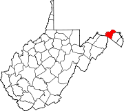
Mount Trimble — Unincorporated community — Location within the state of West Virginia Coordinates: 39°38′24″N 78°6′35″W / 39.64°N 78.10972°WCoordinates: 39°38′24″N 78°6′35″W / 39.64°N 78.10972°W Country United States State West Virginia County Morgan Time zone Eastern (EST) (UTC-5) – Summer (DST) EDT (UTC-4) ZIP codes FIPS code GNIS feature ID Mount Trimble is an unincorporated community in Morgan County in the U.S. state of West Virginia's Eastern Panhandle. Mount Trimble is situated around the crossroads at Michael's Chapel near the confluence of Sleepy Creek and Meadow Branch.
Historic sites
- Michael's Chapel
Municipalities and communities of Morgan County, West Virginia Towns CDP Unincorporated
communitiesBerryville | Burnt Factory | Campbells | Cherry Run | Doe Gully | Duckwall | Green Ridge | Greenwood | Hancock | Hansrote | Holton | Jerome | Jimtown | Johnsons Mill | Largent | Lineburg | Magnolia | Mount Trimble | New Hope | North Berkeley | Oakland | Omps | Orleans Cross Roads | Redrock Crossing | Ridersville | Ridge | Rock Gap | Sir Johns Run | Sleepy Creek | Smith Crossroads | Spohrs Crossroads | Stotlers Crossroads | Unger | Woodmont | Woodrow
Categories:- Eastern Panhandle geography stubs
- Populated places in Morgan County, West Virginia
- Unincorporated communities in West Virginia
Wikimedia Foundation. 2010.


