- Orleans Cross Roads, West Virginia
-
Orleans Cross Roads — Unincorporated hamlet — Location within the state of West Virginia
 Orleans Cross Roads
Coordinates: 39°37′28″N 78°22′45″W / 39.62444°N 78.37917°WCoordinates: 39°37′28″N 78°22′45″W / 39.62444°N 78.37917°W Country United States State West Virginia County Morgan Time zone Eastern (EST) (UTC-5) – Summer (DST) EDT (UTC-4) ZIP codes FIPS code GNIS feature ID Orleans Cross Roads is an unincorporated hamlet that lies on the western flanks of Sideling Hill on the Potomac River in Morgan County, West Virginia. To its south, Rockwell Run, a mountain stream fed by springs, empties into the Potomac. Orleans Cross Roads lies along the old Baltimore and Ohio Railroad directly across the river from Little Orleans. It is accessible by way of Orleans Road (CR 18/1) from Cacapon Road (West Virginia Route 9) via Detour Road (CR 18).
Once the site of a functioning station on the B&O, Orleans Cross Roads also had its own operating post office. The community and post office were often known as Orleans Cross Roads or Orleans Crossroads while its station was known as Orleans Road Station. It is still inhabited today and is the site of the historic Orleans Cross Roads Methodist Episcopal Church, built in the 1850s.
Municipalities and communities of Morgan County, West Virginia Towns 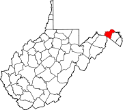
CDP Unincorporated
communitiesBerryville | Burnt Factory | Campbells | Cherry Run | Doe Gully | Duckwall | Green Ridge | Greenwood | Hancock | Hansrote | Holton | Jerome | Jimtown | Johnsons Mill | Largent | Lineburg | Magnolia | Mount Trimble | New Hope | North Berkeley | Oakland | Omps | Orleans Cross Roads | Redrock Crossing | Ridersville | Ridge | Rock Gap | Sir Johns Run | Sleepy Creek | Smith Crossroads | Spohrs Crossroads | Stotlers Crossroads | Unger | Woodmont | Woodrow
Categories:- Populated places in Morgan County, West Virginia
- Unincorporated communities in West Virginia
- Baltimore and Ohio Railroad
- Populated places on the Potomac River
- Eastern Panhandle geography stubs


Wikimedia Foundation. 2010.