- Oakland, West Virginia
-
Oakland — Unincorporated community — Location within the state of West Virginia
 Oakland
Coordinates: 39°28′52″N 78°15′6″W / 39.48111°N 78.25167°WCoordinates: 39°28′52″N 78°15′6″W / 39.48111°N 78.25167°W Country United States State West Virginia County Morgan Time zone Eastern (EST) (UTC-5) – Summer (DST) EDT (UTC-4) ZIP codes FIPS code GNIS feature ID Oakland is an unincorporated community in Morgan County, West Virginia. It is located along Virginia Line Road (CR 8) north of Unger and south of Stotlers Crossroads. Oakland is connected to Valley Road (U.S. Highway 522) by County Route 26 (Oakland and Morton Grove Roads).
History
Oakland sprouted up as a small farming community in the 19th century and established its own post office and school which were both in operation until the early 20th century. The Oakland United Methodist Church remains regularly attended by Oakland area residents.
Municipalities and communities of Morgan County, West Virginia Towns 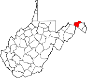
CDP Unincorporated
communitiesBerryville | Burnt Factory | Campbells | Cherry Run | Doe Gully | Duckwall | Green Ridge | Greenwood | Hancock | Hansrote | Holton | Jerome | Jimtown | Johnsons Mill | Largent | Lineburg | Magnolia | Mount Trimble | New Hope | North Berkeley | Oakland | Omps | Orleans Cross Roads | Redrock Crossing | Ridersville | Ridge | Rock Gap | Sir Johns Run | Sleepy Creek | Smith Crossroads | Spohrs Crossroads | Stotlers Crossroads | Unger | Woodmont | Woodrow
Categories:- Populated places in Morgan County, West Virginia
- Unincorporated communities in West Virginia
- Eastern Panhandle geography stubs


Wikimedia Foundation. 2010.