- Meyerstown, West Virginia
-
Meyerstown — Unincorporated community — Location within the state of West Virginia
 Meyerstown
Coordinates: 39°12′21″N 77°51′48″W / 39.20583°N 77.86333°WCoordinates: 39°12′21″N 77°51′48″W / 39.20583°N 77.86333°W Country United States State West Virginia County Jefferson Time zone Eastern (EST) (UTC-5) – Summer (DST) EDT (UTC-4) ZIP codes FIPS code GNIS feature ID Meyerstown is an unincorporated community near the Shenandoah River in Jefferson County, West Virginia, USA. Myerstown is a small community south of Kabletown, at the intersection of Kabletown Road and Myerstown Road. It apparently was named for Joseph Myers, a prosperous farmer, who owned several large tracts of land along Kabletown Road.
Municipalities and communities of Jefferson County, West Virginia Cities 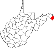
Towns CDPs Unincorporated
communitiesBakerton | Bardane | Blair | Bloomery | Blue Ridge Acres | Browns Corner | Clips Mill | Duffields | Egypt | Engle | Franklintown | Halltown | Jamestown | Johnsontown | Kabletown | Kearneysville | Keyes Ferry Acres | Leetown | Mannings | Mechanicstown | Mechlenberg Heights | Meyerstown | Millville | Moler Crossroads | Mountain Mission | Reedson | Rippon | Riverside | Silver Grove | Skeetersville | Summit Point | Uvilla | Wheatland
Categories:- Eastern Panhandle geography stubs
- Populated places in Jefferson County, West Virginia
- Unincorporated communities in West Virginia


Wikimedia Foundation. 2010.