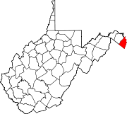
- Mechlenberg Heights, West Virginia
-
Mechlenberg Heights — Unincorporated community — Location within the state of West Virginia Coordinates: 39°26′0″N 77°49′47″W / 39.433333°N 77.82972°WCoordinates: 39°26′0″N 77°49′47″W / 39.433333°N 77.82972°W Country United States State West Virginia County Jefferson Time zone Eastern (EST) (UTC-5) – Summer (DST) EDT (UTC-4) ZIP codes FIPS code GNIS feature ID Mechlenberg Heights is an unincorporated community in Jefferson County, West Virginia, USA. Mechlenberg Heights lies to the west of Shepherdstown along West Virginia Route 45.
External links
- Shepherdstown Forums - Discussion Forums
Municipalities and communities of Jefferson County, West Virginia Cities Towns CDPs Unincorporated
communitiesBakerton | Bardane | Blair | Bloomery | Blue Ridge Acres | Browns Corner | Clips Mill | Duffields | Egypt | Engle | Franklintown | Halltown | Jamestown | Johnsontown | Kabletown | Kearneysville | Keyes Ferry Acres | Leetown | Mannings | Mechanicstown | Mechlenberg Heights | Meyerstown | Millville | Moler Crossroads | Mountain Mission | Reedson | Rippon | Riverside | Silver Grove | Skeetersville | Summit Point | Uvilla | Wheatland
Categories:- Eastern Panhandle geography stubs
- Populated places in Jefferson County, West Virginia
- Unincorporated communities in West Virginia
Wikimedia Foundation. 2010.


