- Melrose (Metro-North station)
-
Melrose 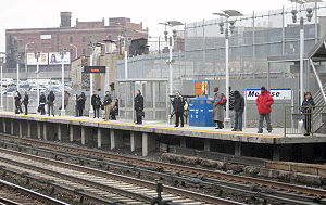
Melrose Metro-North Station Jan. 7, 2008Station statistics Address 3231 Park Avenue
Bronx, NYCoordinates 40°49′33″N 73°54′55″W / 40.8257°N 73.9154°WCoordinates: 40°49′33″N 73°54′55″W / 40.8257°N 73.9154°W Lines Connections  NYCT Buses: Bx6, Bx13, Bx32, Bx41
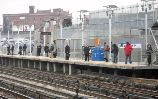
Platforms 2 side platforms Tracks 4 Other information Electrified 700V (DC) third rail Fare zone 2 Services Preceding station Metro-North Railroad Following station Harlem – 125th Streettoward Grand CentralHarlem Line toward WassaicThe Melrose (also known as Melrose – East 162nd Street) Metro-North Railroad station serves the residents of the Melrose section of The Bronx via the Harlem Line. It is 6.1 miles (9.8 km) from Grand Central Terminal and is located in an open cut beneath Park Avenue at its intersection with East 162nd Street, six tenths of a mile from Yankee Stadium. Service at Melrose is limited; trains stop every 30 minutes during rush hours, every two hours mid-days and evenings.
This station is the first/last station in the Zone 2 Metro-North fare zone, and is the first/last station of the CityTicket inter-city ticket zone.
When Melrose station was originally built by the New York Central Railroad in the late-19th Century, it contained a station house over all four tracks, with two island platforms. Similar structures were built for the former Morrisania Station, as well as Tremont Station. The station was renovated, with the northbound platform moved out from underneath the overpass to its current location, circa 2006.
Within walking distance
The immediate neighborhood is a mixed-use district including many apartment buildings, courthouses, and retail shopping along 161st Street. One block west at Morris Avenue is the Bronx County Hall of Justice, a nine-story, 775,000-square-foot (72,000 m2) court house with 47 courtrooms that opened in January 2008. A block west along 161st Street, between Sheridan and Sherman Avenues, is the Bronx Family Court building. Continuing west, one finds the Concourse Plaza Hotel (now a home for the aged), the Bronx County Building (borough hall plus more courtrooms), and three blocks further, the new Yankee Stadium.
Platforms and tracks
The station has two high-level side platforms each two cars long reached by stairway from East 162nd Street. When trains stop at this station, normally the front two open cars receive and discharge passengers.
The west platform, generally used by southbound or Manhattan-bound trains, is underneath East 162nd Street and the New York City Housing Authority's Morrisania Air Rights public housing project. The east platform, generally used by northbound or Westchester County-bound trains, is offset from the other and is not underneath those structures.
The Harlem Line has four tracks here. The two inner tracks, not next to either platform, are used by express trains.
External links
Categories:- Metro-North Railroad stations in New York
- Stations along New York Central Railroad lines
- Transportation in the Bronx
Wikimedia Foundation. 2010.