- Dry Tortugas Light
-
Dry Tortugas Light 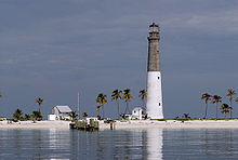
The Dry Tortugas Light is on Loggerhead Key Location Loggerhead Key, Dry Tortugas Coordinates 24°38′00.02″N 82°55′13.958″W / 24.6333389°N 82.92054389°W Year first lit 1858 Automated 1988 Foundation stone Construction brick Tower shape conical tower Markings / pattern Lower half, white
Upper half, natural gray[1]
Lantern, blackHeight 157 feet (47.8 m) Focal height 151 feet (46.0 m) Original lens 1st Fresnel lens
Later, 2nd orderCurrent lens VRB-25 system Range 20 nm Characteristic Flashing white 20s Racon "K" (−∘−) USCG number 3-1095 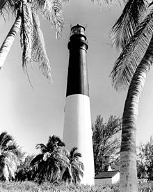 Dry Tortugas Light when the upper part was painted black.
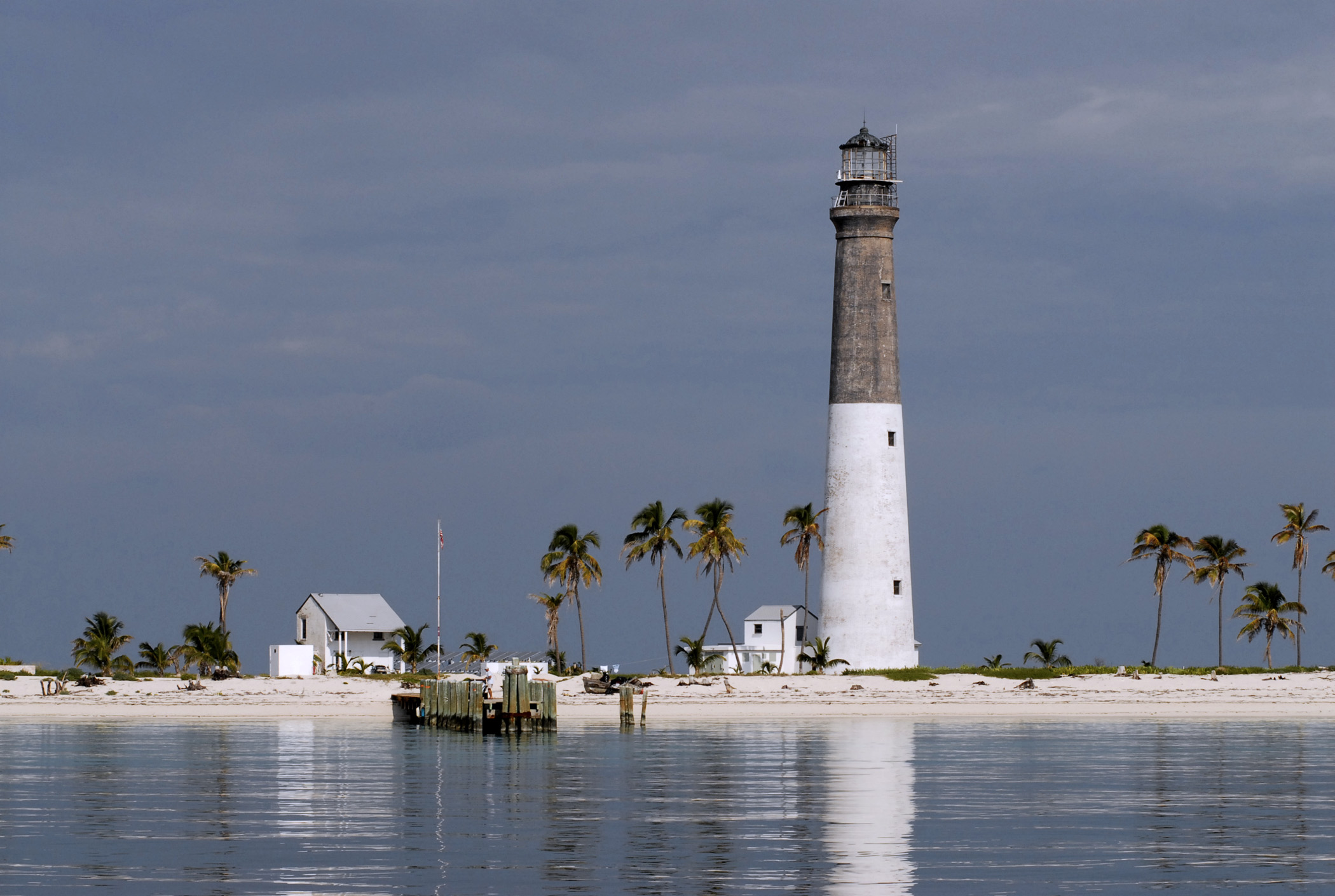
The Dry Tortugas Light is located on Loggerhead Key, three miles west of Fort Jefferson, Florida. A lighthouse was established on Bush Key in 1825, and refitted with a new lantern in 1846. Construction on a new lighthouse on Loggerhead Key began in 1856 and was completed in 1858. The Loggerhead Key lighthouse has a stone foundation and a conical brick tower. The walls are six feet thick at the base and taper to four feet thick at the top. The tower was painted black on the upper part and white below (later unpainted on the upper part and white below). A radio room is attached to the base of the tower. The original lens was a first order Fresnel lens, which is now on display at the United States Coast Guard Aids to Navigation School in Yorktown, Virginia. The light was automated in 1988.
The Dry Tortugas lighthouse, along with the Garden Key lighthouse at Fort Jefferson, were the only lights on the Gulf coast that stayed in full operation throughout the American Civil War. The tower was damaged by a hurricane in October 1873[3] and plans were drawn up for a new tower. However, repairs to the tower were so successful that the plans for a new tower were shelved. Its appearance and striping is similar to the Hunting Island Light, though its construction is different.
Beginning with its electrification in 1931, it was the most powerful lighthouse in America, with three million candela.[3]
References
- ^ The Light List says it's black, but the photographs show unpainted gray stone.
- ^ (PDF) Light List, Volume III, Atlantic Coast, Little River, South Carolina to Econfina River, Florida. Light List. United States Coast Guard. 2009. p. 12. http://www.navcen.uscg.gov/pdf/lightLists/LightList%20V3.pdf.
- ^ a b c "Historic Light Station Information and Photography: Florida". United States Coast Guard Historian's Office. http://www.uscg.mil/history/weblighthouses/LHFL.asp.
See also
- McCarthy, Kevin M. (1990). 'Florida Lighthouses. Paintings by William L. Trotter. Gainesville: University of Florida Press. ISBN 0-8130-0982-0.
- Dean, Love (1982). Reef Lights: Seaswept Lighthouses of the Florida Keys. Key West, Florida: The Historic Key West Preservation Board. ISBN 0-943528-03-8.
Lighthouses of Florida See also: List of operating lighthouses in Florida Alligator Reef • Amelia Island • Amelia Island North Range • American Shoal • Anclote Keys • Cape Canaveral • Cape Florida • Cape San Blas • Cape St. George • Carysfort Reef • Cedar Key • Charlotte Harbor • Crooked River • Dames Point • Dog Island • Dry Tortugas • Egmont Key • Fowey Rocks • Garden Key • Gasparilla Island • Hillsboro Inlet • Jupiter Inlet • Key West • Northwest Passage • Pensacola • Ponce de Leon Inlet • Rebecca Shoal • Sand Key • Sanibel Island • Sombrero Key • St. Augustine • St Johns • St. Johns River • St. Joseph Point • St. Marks • Unmanned reef lights of the Florida Keys • Volusia Bar Categories:
- Lighthouses in Monroe County, Florida
- Buildings and structures completed in 1858
- Dry Tortugas National Park


Wikimedia Foundation. 2010.