Amelia Island North Range Light

Amelia Island North Range Light

Infobox_Lighthouse


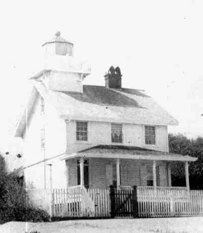
caption = The 1872 Amelia Island North Range Lighthouse
location = mouth of the St. Mary's River
coordinates =
yearlit = 1858, rebuilt 1872
automated =
yeardeactivated = 1899
foundation =
construction = wood
shape = house
height =
lens =
range =
characteristic =
The Amelia Island North Range Light was built to mark a channel over the sandbar at the mouth of the St. Mary's River, which led to the harbor at Fernandina Beach, Florida, on Amelia Island. It consisted of a lighthouse and a front range tower with a light, arranged so that when ships could see one light above the other, they were lined up with the channel. During the Civil War Confederate forces removed the lenses from the lights. Union forces seized Fernandina Beach, Fort Clinch and the lighthouse in 1862.

It is known that the front range tower was destroyed during the war. There is no record of when the lighthouse was destroyed, but a new lighthouse was built in 1872. As the channel over the sand bar shifted with time, the front range light was periodically moved to maintain an alignment with the channel. In 1887 the rear range light was moved from the lighthouse to a tramway to permit proper adjustments to be made to the alignment. The light was decommissioned in 1899 after the channel was sufficiently marked with buoys. The lighthouse was listed in a survey in 1924, but has since disappeared.

References

* [http://web.archive.org/web/20060208234113/http://users.erols.com/lthouse/ainhs.htm Florida Lighthouse Page - Amelia Island North Range Lighthouse History] - accessed January 16 2006, recovered using [http://web.archive.org/collections/web.html Wayback Machine] on January 22, 2007
* [http://www.uscg.mil/history/weblighthouses/LHFL.asp U.S. Coast Guard Historic Light Station Information - Florida] - accessed June 29 2008


Wikimedia Foundation. 2010.

Игры ⚽ Нужно сделать НИР?

Look at other dictionaries:

  • Amelia Island Light — Infobox Lighthouse caption = Amelia Island lighthouse (from U.S. Coast Guard archives) location = north end of Amelia Island at the mouth of the St. Mary s River coordinates = coord|30|40|23.46|N|81|26|32.8|W|type:landmark yearlit = 1838… …   Wikipedia

  • Ponce de Leon Inlet Light — The Mosquito Inlet Light, later known as the Ponce De Leon Inlet Light Location 4931 South Peninsula Dr Ponce de Leon Inlet Ponce Inlet, Florida South of Daytona Year first constructed 1835 Year first lit 1887 (current structure) …   Wikipedia

  • Crooked River Light — Location near Carrabelle, Florida Coordinates …   Wikipedia

  • Dames Point Light — Location on the shoals off Dames Point, St. Johns River, Florida Coordinates 30°23′00″N 81°33′16″W /  …   Wikipedia

  • Dry Tortugas Light — The Dry Tortugas Light is on Loggerhead Key Location Loggerhead Key, Dry Tortugas Coordinates …   Wikipedia

  • St. Johns River Light — Not to be confused with St. Johns Light. St. Johns River Light St. Johns River lighthouse Location Near the mouth of the St. Johns River on the property of Naval Station Mayport Coordinates …   Wikipedia

  • Dog Island Light — The Dog Island Lighthouse before is was damaged by a hurricane in 1872. Location western tip of Dog Island Florida Coordinates Est …   Wikipedia

  • Northwest Passage Light — Light station marking the northwest passage to Key West in 1892 Location Westerly side of the northerly end of the northwest channel to Key West harbor Coordinates …   Wikipedia

  • Charlotte Harbor Light — The Charlotte Harbor lighthouse (from U.S. Coast Guard archives) Location Charlotte Harbor, on the channel to Punta Gorda, Florida Coordinates Est …   Wikipedia

  • Amelia Earhart — Earhart redirects here. For the asteroid, see 3895 Earhart. Amelia Earhart Amelia Earhart …   Wikipedia

Share the article and excerpts

Direct link
Do a right-click on the link above
and select “Copy Link”