- Gasparilla Island Lights
Infobox_Lighthouse

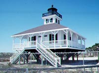
caption = The Gasparilla Island Lighthouse has been restored and is now a museum.
location = south tip ofGasparilla Island , on the Boca Grande Pass
coordinates = coord|26|43|02|N|82|15|39|W|region:US_type:landmark
yearlit = 1890
automated = 1956
yeardeactivated = 1966, reactivated 1986
foundation = iron screw piles
construction = wood frame
shape = octagonal lantern at roof peak of a square house
height = 44 feet
lens = three and a half orderFresnel lens
range =
characteristic = fixed white light varied by red flashes every 20 secondsInfobox_Lighthouse

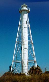
caption = The Gasparilla Island Rear Range Light was first lit in 1932.
location = 1 mile north of the first lighthouse
coordinates = coord|26|44|31|N|82|15|48|W|region:US_type:landmark
yearlit = 1932
automated = 1956
yeardeactivated =
foundation = ironsteel pile s
construction =wrought iron
shape = skeletal tower
height = 105 feet
lens = fourth orderFresnel lens
range =
characteristic = The Gasparilla Island Lights are onGasparilla Island inBoca Grande, Florida . The first Gasparilla Island lighthouse is on the south tip of Gasparilla Island, and marked the Boca Grande Pass entrance to Charlotte Harbor. It has also been known as the Boca Grande Light and the Port Boca Grande Light. The second Gasparilla Island light is one mile north of the first lighthouse. It has also been known as the Boca Grande Light and the Boca Grande Light Rear Range.First Gasparilla Island Light
The first Gasparilla Island Light was first lit on
December 31 1890 . It is a one-story frame dwelling raised on iron screw-piles, with the lantern placed at the peak of the roof. The keeper lived in the lighthouse. A similar house (without a lantern) built next to it was the assistant keeper's dwelling.The Gasparilla Island Light originally served ships transporting cattle from ports on Charlotte Harbor to
Cuba .Phosphate ore from the Peace River area became an important cargo in the 1890s, and an extension of theSeaboard Air Line Railway to Port Boca Grande in 1909 resulted in increased traffic. Ship traffic to Port Boca Grande peaked at more than 30 ships a month duringWorld War II .The Gasparilla Island Light was deactivated in 1966, and abandoned by the Coast Guard in 1969. The buildings quickly deteriorated, and by 1970 beach erosion had exposed the screw-piles supporting the building, with waves breaking under the building at high tide. A rock jetty was built to protect the lighthouse, and sand was pumped in to build up the beach. Lee County took title the lighthouse in 1972. On
February 28 ,1980 , the lighthouse was placed on theNational Register of Historic Places . The buildings were restored in 1985-1986. In 1986 the light was re-lit and the station was put back into service.The Gasparilla Island Light is now part of the
Gasparilla Island State Park . The lighthouse houses the Boca Grande Lighthouse Museum.Hurricane Charley , which caused extensive damage around Charlotte Harbor in 2004, tore off thecatwalk around the top of the lighthouse, damaged windows and destroyed two originalredcedar cistern s. The museum reopened to the public a week later. Enough wood and hardware were found from the original cisterns to rebuild one of them, and the second was later replaced using new materials.In 2006, the museum underwent extensive renovation. A paint specialist was able to retrieve a sample of an early paint color, and the interior was repainted. The floors were stripped of a dark varnish used in the original restoration, and were refinished with a clear varnish.
econd Gasparilla Island Light
The second Gasparilla Island Light was originally constructed in 1881 to serve as the Delaware Breakwater Rear Range Light. The light was discontinued in 1918. The tower was disassembled in 1921, and reassembled on Gasparilla Island in 1927. However, the light was not lit until 1932, when it served as the rear entrance range light for Port Boca Grande, with the front entrance range light approximately one mile off shore in the Gulf of Mexico. It has since fallen into the Gulf.
When the two lights, which flashed at different rates, lined up, the ships' navigators knew it was time to turn to enter Gasparilla Pass.
References
* McCarthy, Kevin M. (1990). "Florida Lighthouses", Paintings by William L. Trotter,
Gainesville, Florida :University of Florida Press. ISBN 0-8130-0982-0.
* [http://www.cr.nps.gov/maritime/light/gasparil.htm National Park Service Inventory of Historic Light Stations - Florida Lighthouses] - retrievedJanuary 20 2006
* [http://www.nationalregisterofhistoricplaces.com/FL/Lee/state.html Lee County listings] at [http://www.nationalregisterofhistoricplaces.com National Register of Historic Places]
* [http://www.uscg.mil/history/weblighthouses/LHFL.asp U.S. Coast Guard Historic Light Station Information & Photography - Florida] - retrievedJune 29 2008
* [http://www.flheritage.com Florida's Office of Cultural and Historical Programs]
** [http://www.flheritage.com/facts/reports/places/index.cfm?fuseaction=ListAreas&county=lee Lee County listings]
** [http://www.flheritage.com/services/sites/fht/record_t.cfm?ID=456&type=c&index=36 Boca Grande Lighthouse Museum]
* [http://web.archive.org/web/20060209192855/http://users.erols.com/lthouse/gilt.htm Gasparilla Island (Port Boca Grande) Lighthouse] - retrievedJune 29 2008
* [http://www.unc.edu/~rowlett/lighthouse/fl.htm Florida Lighthouses] - retrievedJanuary 20 2006
* [http://arlhs.com/awards/U_list.html Amateur Radio Lighthouse Society (coordinates)] - retrievedFebruary 4 2006
Wikimedia Foundation. 2010.
