- Skaneateles (town), New York
-
Skaneateles — Town — A home on the west shore of Skaneateles Lake.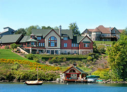 Location of Skaneateles in New York
 Skaneateles
Coordinates: 42°56′48″N 76°25′42″W / 42.94667°N 76.42833°WCoordinates: 42°56′48″N 76°25′42″W / 42.94667°N 76.42833°W Country United States State New York County Onondaga Government – Type Town Council – Town Supervisor Terri Roney (R) – Town Council Members' ListPopulation (Census 2000)[1] – Total 7,323 Skaneateles (/ˌskæniˈætləs/, locally /ˌskɪniˈætləs/[2]) is a town in Onondaga County, New York, United States. The population was 7,323 at the 2000 census.[1] The name is from the Iroquois "Indian" tribe term for the adjacent lake: "long lake." The town is on the western border of the county and includes a village, also called Skaneateles. Both town and village are southwest of Syracuse, New York.
Contents
History
The area was part of the former Central New York Military Tract. The town of Skaneateles was formed in 1830 from the town of Marcellus. Early turnpikes facilitated development, as mentioned in the article about the village of Skaneateles. The town was noted for participation in reform movements prior to the Civil War.
The utopian Skaneateles Community in 1843 acquired and successfully operated a large farm and developed small industries, but ultimately failed because of internal difficulties, as well as external concern about its unorthodox social practices. Locally it was sometimes called "No God," because of the atheistic views of members. The Skaneateles Community published a newspaper, the "Comunitist" [sic] between 1844 and 1846, when the community dissolved. Buildings are extant, known as "Community Place," now serving a bed-and-breakfast function.
Some Skaneateles men volunteered for the ill-fated campaign (Patriot War, 1848) to liberate Canada and were imprisoned by the British in Tasmania. Quaker congregations were involved in abolition activity. Underground Railroad sites have been documented in the town of Skaneateles. Although the larger city of Syracuse nearby was known nationally as a center of abolition and Underground Railroad activity, Skaneateles was said (by Beauchamp, an early historian) to have "eclipsed Syracuse as an anti-slavery town."
Geography
According to the United States Census Bureau, the town has a total area of 48.8 square miles (126.3 km²), of which, 42.7 square miles (110.5 km²) of it is land and 6.1 square miles (15.8 km²) of it (12.51%) is water.
Demographics
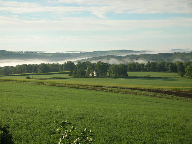
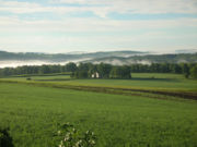 Farms and rolling hills surround Skaneateles Lake.
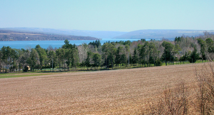
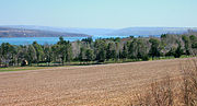 Skaneateles Lake looking south from the west side of the lake.
As of the census[1] of 2000, there were 7,323 people, 2,881 households, and 2,082 families residing in the town. The population density was 171.7 people per square mile (66.3/km²). There were 3,233 housing units at an average density of 75.8 per square mile (29.3/km²). The racial makeup of the town was 98.99% White, 0.10% Black or African-American, 0.10% Native American, 0.36% Asian, 0.04% from other races, and 0.42% from two or more races. Hispanic or Latino of any race were 0.42% of the population.
There were 2,881 households out of which 33.6% had children under the age of 18 living with them, 62.2% were married couples living together, 7.6% had a female householder with no husband present, and 27.7% were non-families. 24.3% of all households were made up of individuals and 13.0% had someone living alone who was 65 years of age or older. The average household size was 2.54 and the average family size was 3.03.
In the town the population was spread out with 26.5% under the age of 18, 4.4% from 18 to 24, 24.5% from 25 to 44, 28.3% from 45 to 64, and 16.3% who were 65 years of age or older. The median age was 42 years. For every 100 females there were 95.3 males. For every 100 females age 18 and over, there were 89.8 males.
The median income for a household in the town was $57,550, and the median income for a family was $69,023. Males had a median income of $51,621 versus $31,250 for females. The per capita income for the town was $28,624. About 1.8% of families and 3.2% of the population were below the poverty line, including 1.1% of those under age 18 and 3.7% of those age 65 or over.
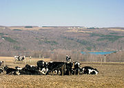 High pasture, west side of lake.
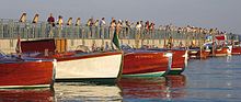 Residents and visitors stroll along Skaneateles’ pier, just off Clift Park in the village of Skaneateles, for the best view of antique boats during Skaneateles’ annual Antique and Classic Boat Show.
Communities and locations in the Town of Skaneateles
- Highland Way – A neighborhood just east of Skaneateles, Onondaga Rd
- Jones Beach – A hamlet on the east shore of Skaneateles Lake on NY-41.
- Long Bridge – A hamlet at the north town line, north of Mottville.
- Mandana – A hamlet down the west side of the lake.
- Mottville – A hamlet two miles north of Skaneateles village on Jordan Street and north of Willow Glen.
- Shepard Settlement – A farming hamlet.
- Skaneateles – A village at the north end of Skaneateles Lake.
- Thornton Grove – A lakeshore neighborhood on the west side of the lake south of Winding Way.
- Thornton Heights – A lakeshore neighborhood on the west side of the lake home of the Veggie Stand.
- Wicks Corners – A neighborhood on the west town line, northwest of Skaneateles village.
- Willow Glen – A neighborhood on Old Seneca Turnpike, located north of Skaneateles village.
- Winding Way – A neighborhood on the west shore of Skaneateles Lake.
References
- ^ a b c "American FactFinder". United States Census Bureau. http://factfinder.census.gov. Retrieved 2008-01-31.
- ^ Kenyon, John S.; Knott, Thomas A. (1953). A Pronouncing Dictionary of American English. Springfield, Mass.: Merriam-Webster. p. 393. ISBN 0-87779-047-7.
- William Beauchamp. "Notes of other days in Skaneateles, written for the Skaneateles democrat in 1876. Cornell Library New York State Literature [1]
- Hamm, Thomas D., God's Government Begun: The Society fo Universal Inquiry and Reform, 1842-1846. Indian University Press, 1995.
- Hamm, Thomas D. "Skaneateles Community." Encyclopedia of New York State, Syracuse University Press, 2005.
- Fogarty, Robert. "Utopian and Intentional Communities," The Encyclopedia of New York State. Syracuse University Press, 2005.
External links
- Town of Skaneateles, NY, Government Site
- Khim Winship. ""The Town of Skaneateles." 2005.
- History, Town of Skaneateles
- Skaneateles area Chamber of Commerce
- Skaneateles Town Court
- Skaneateles Underground Railroad Sites
- Skaneateles Wiki
Municipalities and communities of Onondaga County, New York City 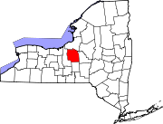
Towns Villages Baldwinsville | Camillus | East Syracuse | Elbridge | Fabius | Fayetteville | Jordan | Liverpool | Manlius | Marcellus | Minoa | North Syracuse | Skaneateles | Solvay | Tully
CDPs Brewerton‡ | Bridgeport‡ | Fairmount | Galeville | Lakeland | Lyncourt | Mattydale | Nedrow | Seneca Knolls | Village Green | Westvale
Other
hamletsAmber | Amboy | Apulia | Apulia Station | Borodino | Cardiff | Cedarvale | Clintonville | Collingwood | Delphi | Delphi Falls | Geddes | Hart Lot | Hinsdale | Howlett Hill | Indian Village | Jack's Reef | Jamesville | Long Branch | Marietta | Memphis | Messina Springs | Mottville | Mycenae | Navarino | Onondaga Hill | Oran | Otisco | Plainville | Pompey Center | Rose Hill | Shepard Settlement | Skaneateles Falls | South Onondaga | South Spafford | Southwood | Spafford Valley | Split Rock | State Fair Grounds | Taunton | Thorn Hill | Vesper | Warners | Watervale
Indian
reservationFootnotes ‡This populated place also has portions in an adjacent county or counties
Categories:- Towns in New York
- Syracuse metropolitan area
- Populated places in Onondaga County, New York


Wikimedia Foundation. 2010.