- Duxbury (CDP), Massachusetts
-
Duxbury, Massachusetts — CDP — John Alden House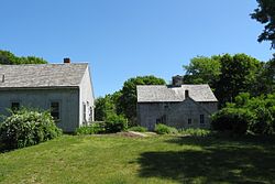
Coordinates: 42°2′34″N 70°40′23″W / 42.04278°N 70.67306°WCoordinates: 42°2′34″N 70°40′23″W / 42.04278°N 70.67306°W Country United States State Massachusetts County Plymouth Area – Total 2.6 sq mi (6.8 km2) – Land 2.2 sq mi (5.6 km2) – Water 0.5 sq mi (1.2 km2) Elevation 16 ft (5 m) Population (2000) – Total 1,426 – Density 656.1/sq mi (253.3/km2) Time zone Eastern (EST) (UTC-5) – Summer (DST) EDT (UTC-4) ZIP codes 02331-02332 Area code(s) 781 FIPS code 25-17860 GNIS feature ID 0615025 Duxbury is a census-designated place (CDP) in the town of Duxbury in Plymouth County, Massachusetts, United States. The population was 1,426 at the 2000 census.
Geography
Duxbury is located at 42°2′34″N 70°40′22″W / 42.04278°N 70.67278°W (42.042891, -70.672928)[1].
According to the United States Census Bureau, the CDP has a total area of 6.8 km² (2.6 mi²). 5.6 km² (2.2 mi²) of it is land and 1.2 km² (0.4 mi²) of it (17.18%) is water.
Demographics
As of the census[2] of 2000, there were 1,426 people, 499 households, and 415 families residing in the CDP. The population density was 253.7/km² (656.1/mi²). There were 567 housing units at an average density of 100.9/km² (260.9/mi²). The racial makeup of the CDP was 98.18% White, 0.07% Black or African American, 0.14% Native American, 0.84% Asian, 0.35% from other races, and 0.42% from two or more races. Hispanic or Latino of any race were 0.70% of the population.
There were 499 households out of which 40.7% had children under the age of 18 living with them, 78.4% were married couples living together, 4.4% had a female householder with no husband present, and 16.8% were non-families. 14.4% of all households were made up of individuals and 6.0% had someone living alone who was 65 years of age or older. The average household size was 2.86 and the average family size was 3.19.
In the CDP the population was spread out with 29.4% under the age of 18, 3.9% from 18 to 24, 20.9% from 25 to 44, 33.1% from 45 to 64, and 12.7% who were 65 years of age or older. The median age was 42 years. For every 100 females there were 97.0 males. For every 100 females age 18 and over, there were 91.4 males.
The median income for a household in the CDP was $105,683, and the median income for a family was $125,346. Males had a median income of $85,783 versus $45,417 for females. The per capita income for the CDP was $44,589. About 1.6% of families and 2.6% of the population were below the poverty line, including 3.7% of those under age 18 and 5.3% of those age 65 or over.
References
- ^ "US Gazetteer files: 2010, 2000, and 1990". United States Census Bureau. 2011-02-12. http://www.census.gov/geo/www/gazetteer/gazette.html. Retrieved 2011-04-23.
- ^ "American FactFinder". United States Census Bureau. http://factfinder.census.gov. Retrieved 2008-01-31.
Municipalities and communities of Plymouth County, Massachusetts Cities 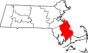
Towns Abington | Carver | Duxbury | East Bridgewater | Halifax | Hanover | Hanson | Hingham | Hull | Kingston | Lakeville | Marion | Marshfield | Mattapoisett | Middleborough | Norwell | Pembroke | Plymouth | Plympton | Rochester | Rockland | Scituate | Wareham | West Bridgewater | Whitman
CDPs Bridgewater | Duxbury | Green Harbor-Cedar Crest | Hanson | Hingham | Kingston | Marion Center | Marshfield | Marshfield Hills | Mattapoisett Center | Middleborough Center | North Lakeville | North Pembroke | North Plymouth | North Scituate | Ocean Bluff-Brant Rock | Onset | Plymouth Center | Scituate | South Duxbury | Wareham Center | West Wareham | Weweantic | White Island Shores
Other
villagesCategories:- Census-designated places in Plymouth County, Massachusetts


Wikimedia Foundation. 2010.