- Alston Moor
-
Coordinates: 54°48′43″N 2°26′28″W / 54.812°N 2.441°W
Alston Moor 
Alston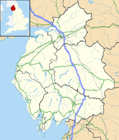
 Alston Moor
Alston Moor shown within CumbriaPopulation 2,156 (2001) OS grid reference NY7146 Parish Alston Moor District Eden Shire county Cumbria Region North West Country England Sovereign state United Kingdom Post town ALSTON Postcode district CA9 Dialling code 01434 Police Cumbria Fire Cumbria Ambulance North West EU Parliament North West England UK Parliament Penrith and the Border List of places: UK • England • Cumbria Alston with Garrigill Geography Status Rural district HQ Alston Town Hall History Created 1894 Abolished 1974 Succeeded by District of Eden Alston Moor is an area of moorland and civil parish in Cumbria, England, based around the small town of Alston. The parish had a population of 2,156 at the 2001 census. As well as the town of Alston, the parish includes the villages of Garrigill and Nenthead, along with the hamlets of Nenthall, Nentsberry, Galligill, Blagill, Ashgill, Ayle, Leadgate, Bayles and Raise. Alston Moor is part of the North Pennines Area of Outstanding Natural Beauty (AONB), the second largest of the 40 AONBs in England and Wales.
Under the Local Government Act 1894, the parish, then known as Alston with Garrigill, which had previously been a rural sanitary district on its own, became one of the few single-parish rural districts. This remained in existence until 1974 when it became part of the Eden district. The parish is divided into the wards of Alston (which includes Leadgate), Garrgill and Nenthead.
The parish is drained by the River South Tyne whose source is located in the fells above Garrigill and also by the Rivers Nent and Black Burn which along with many other smaller streams flow into the Tyne. The Rivers Tees and Wear also have their sources on the borders of the parish.
The manor of Alston or Alston Moor was held for many centuries by the Radcliffe family who held the title Earl of Derwentwater, but after the part in the failed 1715 Jacobite Rising, the lands were confiscated, and Alston became the property of the naval hospital at Greenwich in London.
Greenwich Hospital remained the principal landowner in the parish and owner of the extensive mineral rights up until the 1960s when the estate was transferred to the Trustees for Catholic Purposes who a few years ago sold their remaining properties in Alston Moor.
 Randalhome Hall
The poet W. H. Auden was to travel a great deal in Britain and abroad, but it is the wild region between the River Tees and the Roman Wall which provides the backdrop to many poems and plays of the ‘20s and ’30s, and echoes at intervals throughout his life. In America in 1947, an Ordnance Survey map of Alston Moor hung on the wall of Auden’s chaotic shack on Fire Island.
According to his brother John, Auden came to love Alston Moor more than any other place. The poem entitled ’Alston Moor’ dates from 1924, as does ’Allendale’.
Close to the river South Tyne, 2 miles north of Alston, lies Randalholme Hall, a 17th century house incorporating a fourteenth century pele tower.[1]
References
Related websites
- Cybermoor community website with news, comment, webcams and information about Alston Moor
- North Pennines AONB - information about what's happening in this protected landscape
- South Tynedale Railway Official Website
- Wright Bros Coaches Website
- Northumbrian Railways
- Screensavers of Alston by Sam Burt
- Alston Moor Newsletter
Ceremonial county of Cumbria Boroughs or districts Major settlements - Alston
- Ambleside
- Appleby-in-Westmorland
- Aspatria
- Barrow-in-Furness
- Bowness-on-Windermere
- Brampton
- Broughton-in-Furness
- Carlisle
- Cleator Moor
- Cockermouth
- Dalton-in-Furness
- Egremont
- Grange-over-Sands
- Harrington
- Kendal
- Keswick
- Kirkby Lonsdale
- Kirkby Stephen
- Longtown
- Maryport
- Millom
- Penrith
- Sedbergh
- Silloth
- Ulverston
- Whitehaven
- Wigton
- Windermere
- Workington
See also: List of civil parishes in Cumbria
Topics Categories:- Geography of Cumbria
- Civil parishes in Cumbria
- Districts of England abolished by the Local Government Act 1972
- Districts of England created by the Local Government Act 1894


Wikimedia Foundation. 2010.