Bolingbroke, Lincolnshire
- Bolingbroke, Lincolnshire
-
Coordinates: 53°10′00″N 0°00′58″E / 53.16658500°N 0.01601565°E / 53.16658500; 0.01601565
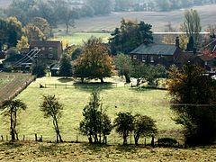
Bolingbroke, now called Old Bolingbroke, is a village near Spilsby in Lincolnshire, England. The village of New Bolingbroke lies 6 miles (9.7 km) to the south-west.
The Prime Meridian passes to the west of Old Bolingbroke.
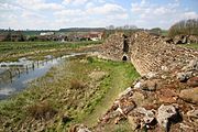
Bolingbroke Castle
William de Roumare, Earl of Lincoln (born circa 1096) built Old Bolingbroke Castle in the 12th century, a motte and bailey castle, with a wet ditch. In the early 13th century, a new castle was constructed at the present site by Ranulph de Blondeville, 4th Earl of Chester. Later John of Gaunt, the son of Edward III, acquired the castle; and in 1367 it became the birthplace of John's son Henry, known as Henry Bolingbroke, who became King Henry IV of England. The castle underwent a Civil War siege in 1643, as the Royalists used it to garrison troops prior to the Battle of Winceby (11 October 1643). The last remaining structure fell down in 1815. The site eventually became a grassy hillock, which archeologists excavated in the 1970s.
References
External links
Categories: - Villages in Lincolnshire
- Civil parishes in Lincolnshire
- East Lindsey
- Lincolnshire geography stubs
Wikimedia Foundation.
2010.
Look at other dictionaries:
Bolingbroke — is the name of:* Henry IV of England, also known as Henry of Bolingbroke * Henry St John, 1st Viscount Bolingbroke (1678 ndash;1751), a Tory party Jacobite grandee and British statesman * other Lords Bolingbroke bearing the title Earl of… … Wikipedia
Bolingbroke Castle — is at Bolingbroke (or Old Bolingbroke) in Lincolnshire (gbmapping|TF349649).HistoryThe present structure was founded by Ranulf, Earl of Chester, in around 1220, and in 1311 passed to the House of Lancaster. Its most famous owner was John of Gaunt … Wikipedia
Lincolnshire — For other places with the same name, see Lincolnshire (disambiguation). Coordinates: 53°4′N 0°11′W / 53.067°N 0.183°W / 53.067; 0.183 … Wikipedia
Bolingbroke — This is one of the most famous of all English surnames. It is particularly associated with King Henry 1Vth who reigned 1399 1413, and who was known to history as Henry Bolingbroke. The surname is medieval and locational, and originates from a… … Surnames reference
New Bolingbroke railway station — is a former station in New Bolingbroke, Lincolnshire.[1] Former Services Preceding station Disused railways Following station Tumby Woodside Great Northern Railway Kirkstead and Little Steeping Railway … Wikipedia
New Bolingbroke — Coordinates: 53°06′13″N 0°02′51″W / 53.10371300°N 0.04749083°W / 53.10371300; 0.04749083 … Wikipedia
Henry Bolingbroke — Heinrich IV. Heinrich IV., Herzog von Hereford, Herzog von Lancaster, auch Henry Bolingbroke (engl.: Henry IV.; * April oder Mai 1366 oder 1367 auf Bolingbroke Castle, Lincolnshire; † 20. März 1413 in London) war, nachdem er zuvor Richard II.… … Deutsch Wikipedia
Castillo de Bolingbroke — Saltar a navegación, búsqueda Antiguo castillo de Bolingbroke, hoy en ruinas El castillo de Blongbroke (Bolingbroke Castle) es un castillo que se encuentra en Bolingbroke (o Antiguo Bolingbroke (Old Bolingbroke)) en Lincolnshire. Fue fundado por… … Wikipedia Español
List of places in Lincolnshire — This is a list of places in the ceremonial county of Lincolnshire, England. See the list of places in England for places in other counties.compactTOC NOTOC A *Aby, Addlethorpe, Aisby, South Kesteven, Aisby, West Lindsey, Aisthorpe, Alford,… … Wikipedia
Carrington, Lincolnshire — Coordinates: 53°04′49″N 0°02′41″W / 53.08029000°N 0.04467487°W / 53.08029000; 0.04467487 … Wikipedia

 Bolingbroke, Lincolnshire shown within Lincolnshire

