- Carrington, Lincolnshire
-
Coordinates: 53°04′49″N 0°02′41″W / 53.08029000°N 0.04467487°W
Carrington 
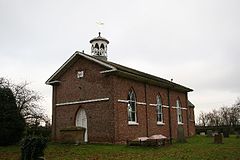
Saint Pauls Church, Carrington
 Carrington shown within Lincolnshire
Population 564 (2001 Census) OS grid reference TF310554 Parish Carrington District East Lindsey Shire county Lincolnshire Region East Midlands Country England Sovereign state United Kingdom Post town Boston Postcode district PE22 Police Lincolnshire Fire Lincolnshire Ambulance East Midlands EU Parliament East Midlands UK Parliament Boston and Skegness List of places: UK • England • Lincolnshire Carrington is a village and civil parish located about 7 miles north of the town of Boston, Lincolnshire, England. The village was created a township in 1812, after the drainage of the West Fen in 1802, and became a civil parish in 1858.[1] The civil parish of Carrington also includes the village of New Bolingbroke[2] and the hamlet of Medlam. The parish has a population of 564 according to the 2001 census.[3]
Carrington church is dedicated to Saint Paul, and was built of red brick in 1816 under the Fen Chapel Act (1816), with its chancel being added in 1872. [4] It is a Grade II listed building.[5]
Carrington's school, the Medlam School, was opened in February 1881 by the West Fen United District School Board which existed from 1879 to 1903. By the time of its closure in 1987 it was known as Carrington County Primary School. Children now attend school in nearby Stickney.[6]
Contents
Carrington Rally
Carrington Rally is an annual event which has taken place each spring for over 50 years, and is a steam and tractor show which supports local charities.[7]
Notable residents
Carrington was the birthplace of William Macbride Childs, the son of the Revd William Linington Childs, vicar of Carrington, and first vice-chancellor of the University of Reading.[8]
External Links
References
- ^ "Vision of Britain". Vision of Britain. http://www.visionofbritain.org.uk/relationships.jsp?u_id=10407394&c_id=10001043. Retrieved 16 May 2011.
- ^ "Carrington Civil Parish - Vision of Britain". Boundary Map. Vision of Britain. http://www.visionofbritain.org.uk/boundary_map_page.jsp?u_id=10407394&c_id=10001043. Retrieved 16 May 2011.
- ^ "Neighbourhood Statistics". Office of National Statistics. http://neighbourhood.statistics.gov.uk/dissemination/LeadTableView.do?a=7&b=796141&c=PE22+7HZ&d=16&e=15&g=467249&i=1001x1003x1004&m=0&r=0&s=1305549546199&enc=1&dsFamilyId=779. Retrieved 16 May 2011.
- ^ "A Church Near You". A Church Near You. http://www.achurchnearyou.com/carrington-st-paul1/. Retrieved 16 May 2011.
- ^ "British Listed Buildings". British Listed Buildings. http://www.britishlistedbuildings.co.uk/en-196216-church-of-st-paul-carrington/map. Retrieved 16 May 2011.
- ^ "Lincs to the Past". Lincolnshire Archives. http://www.lincstothepast.com/CARRINGTON-COUNTY-PRIMARY-SCHOOL/886213.record?pt=S. Retrieved 16 May 2011.
- ^ "Carrington Rally". Visit Lincolnshire. Lincolnshire County Council. http://www.visitlincolnshire.com/site/events/carrington-rally-2010-p168871. Retrieved 16 May 2011.
- ^ Corley, T.A.B.. "Childs, William Macbride (1869–1939), educationist". Oxford Dictionary of National Biography. Oxford University Press. http://www.oxforddnb.com/view/article/32402. Retrieved 2010-02-08.
Categories:- Lincolnshire geography stubs
- Villages in Lincolnshire
- Civil parishes in Lincolnshire
- Visitor attractions in Lincolnshire
- East Lindsey
Wikimedia Foundation. 2010.

