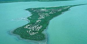
- Chase Lake Wilderness
-
Chase Lake Wilderness Location Stutsman County, North Dakota, USA Nearest city Jamestown, ND Coordinates 47°00′26″N 99°26′43″W / 47.00722°N 99.44528°WCoordinates: 47°00′26″N 99°26′43″W / 47.00722°N 99.44528°W Area 4,155 acres (16.81 km2) Established 1975 Governing body U.S. Fish and Wildlife Service The Chase Lake Wilderness is located in the U.S. state of North Dakota and at 4,155 acres (16.81 km2), it covers the majority of the land area of Chase Lake National Wildlife Refuge. Managed by the U.S. Fish and Wildlife Service, the wilderness was designated by Congress in 1975.
Home to as many as 30,000 White Pelicans, the wilderness preserves habitat for the largest single grouping of pelicans in North America. The pelicans have enjoyed a tremendous rebound from the 50 or so examples that existed in the region when first counted in 1908. Tending to nest on two large islands within the lake for protection from predators, some of the pelicans have been banded and these same birds have been found as far south as the Everglades in Florida during the winter months. Chase Lake is an alkaline lake and supports no fish species, so the pelicans rely on the plentiful Tiger salamander as a food source. The White pelican is the largest of all pelicans; they can have a 10 foot (3 m) wingspan and weigh an average of 20 pounds.
Many other bird species can also be found here including herons, loons, ibises, ducks, geese, hawks and terns to name but a few. White-tailed deer, weasels, coyote and badger also inhabit the wilderness.
No camping is permitted in the wilderness and some areas are completely off limits to people, especially during the nesting season. A few trails allow access for bird watching and visitors are encouraged to remain on designated trails.
U.S. Wilderness Areas do not allow motorized or mechanized vehicles, including bicycles. Although camping and fishing are allowed with proper permit, no roads or buildings are constructed and there is also no logging or mining, in compliance with the 1964 Wilderness Act. Wilderness areas within National Forests and Bureau of Land Management areas also allow hunting in season.
External links
- "Chase Lake Wilderness". The National Wilderness Preservation System, Wilderness.net. http://www.wilderness.net/index.cfm?fuse=NWPS&sec=wildView&wname=Chase%20Lake. Retrieved 2006-08-15.
- "USGS Lake Louise (ND) Topo Map Quad". TopoQuest. http://www.topoquest.com/map.asp?z=14&n=5206786&e=466561&s=50&size=l&u=7&datum=nad83&layer=DRG25. Retrieved 2008-06-29.
- "Wilderness Legislation: The Wilderness Act of 1964". The National Wilderness Preservation System, Wilderness.net. http://www.wilderness.net/index.cfm?fuse=NWPS&sec=legisAct. Retrieved 2006-08-15.
National Parks: National Historic Sites: National Wildlife Refuges: Appert Lake • Ardoch • Arrowwood • Audubon • Bone Hill Creek • Brumba • Buffalo Lake • Camp Lake • Canfield Lake • Chase Lake • Cottonwood Lake • Dakota Lake • Des Lacs • Florence Lake • Halfway Lake • Hiddenwood • Hobart Lake • Hutchinson Lake • J. Clark Salyer • Johnson Lake • Kellys Slough • Lake Alice • Lake George • Lake Ilo • Lake Nettie • Lake Otis • Lake Patricia • Lake Zahl • Lambs Lake • Little Goose • Long Lake • Lords Lake • Lost Lake • Maple River • McLean • Pleasant Lake • Pretty Rock • Rabb Lake • Rock Lake • Rose Lake • School Section Lake • Shell Lake • Sheyenne Lake • Sibley Lake • Silver Lake • Slade • Snyder Lake • Springwater • Stewart Lake • Stoney Slough • Storm Lake • Stump Lake • Sullys Hill National Game Preserve • Sunburst Lake • Tewaukon • Tomahawk • Upper Souris • White Lake • Wild Rice • Willow Lake • Wintering River • Wood LakeNational Grasslands: U.S. Wilderness Areas: Federal Other: State Parks and Recreation Areas: Beaver Lake State Park • Cross Ranch State Park • Devils Lake State Parks • Black Tiger Bay State Recreation Area • Grahams Island State Park • Doyle Memorial State Park • Fort Abraham Lincoln State Park • Fort Ransom State Park • Fort Stevenson State Park • Historic Elmwood • Icelandic State Park • Gunlogson Arboretum Nature Preserve • Indian Hills Resort State Recreation Area • Lake Metigoshe State Park • Lake Sakakawea State Park • Lewis and Clark State Park • Little Missouri State Park • Sully Creek State Recreation Area • Shelver’s Grove State Recreation Area • Turtle River State ParkCategories:- IUCN Category Ib
- Geography of Stutsman County, North Dakota
- Wilderness Areas of North Dakota
- Protected areas established in 1975
Wikimedia Foundation. 2010.


