- Sin Bundang Line
-
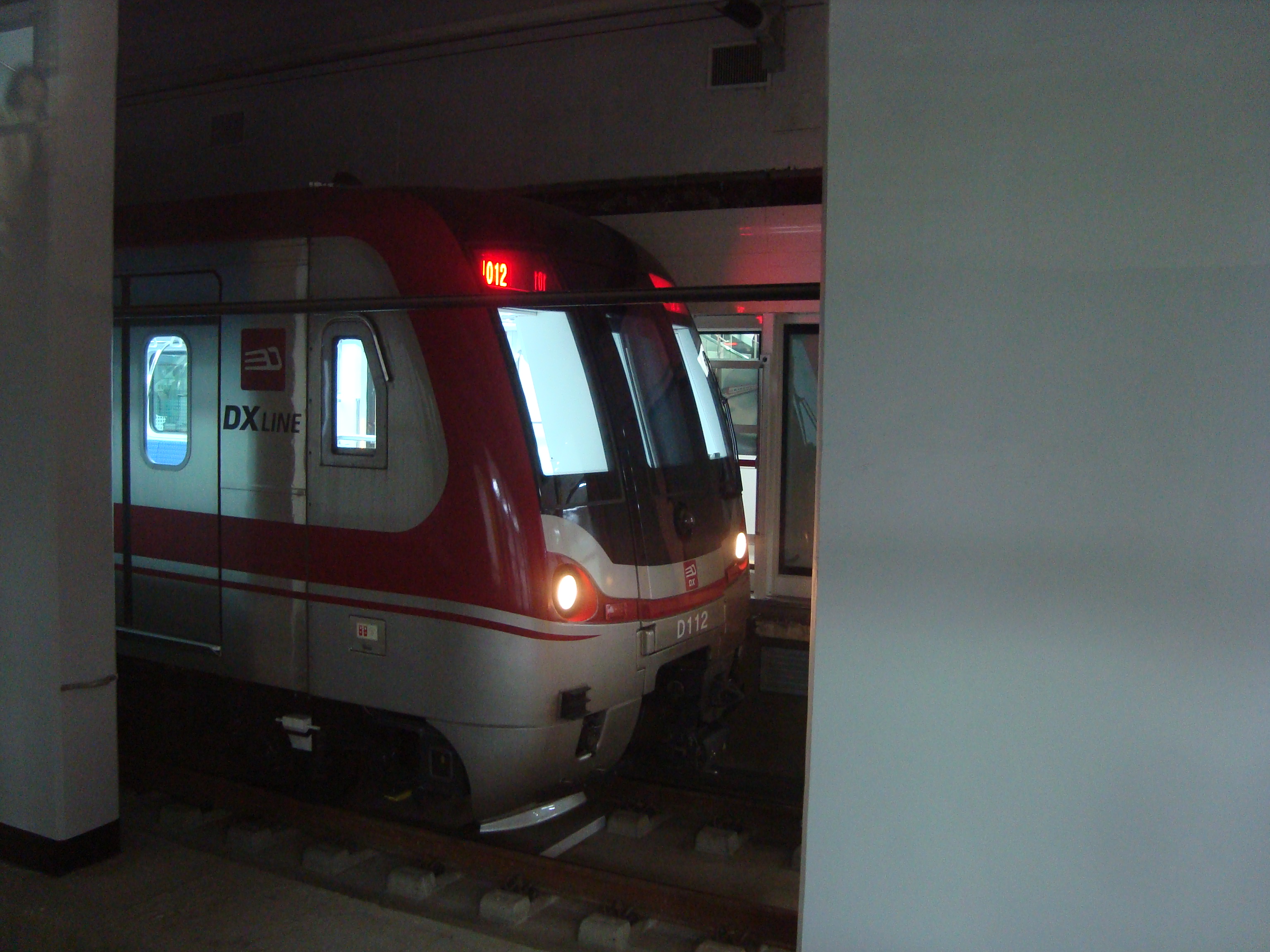
Sin Bundang Line / DX Line
신분당선(新盆唐線)
Sinbundangseon

Statistics Type Commuter rail System Seoul Metropolitan Subway Status Opened Termini Gangnam
JeongjaNo. of stations 6 Operation Opened 28 October 2011 Operator(s) Shin Bundang Line Corporation Technical Line length 17.3 km (10.7 mi) No. of tracks 2 Route diagram The Sin Bundang Line or DX Line ("Sin" pronounced "Shin"; literally The New Bundang Line) is a 17.3 km long, wide-area rail line. It connects to the Seoul Metropolitan Subway. It runs in a north-south direction linking Gangnam in Seoul's south with Jeongja in the Bundang residential district in the southern satellite city of Seongnam.
The initial route passes through 6 stations intersecting with three existing lines at Gangnam Station (Line 2), Yangjae Station (Line 3), and Jeongja Station (Bundang Line). Phase 2 will add several stops to the southern end and Phase 3 is a 7.5 km extension northward from Gangnam station to Yongsan and both are currently under construction. The northern extension will extend the line north-west of Gangnam where it will cross several additional lines before ending at Yongsan Station. This additional stretch is estimated to cost at least 400 billion won.[1]
An existing Bundang Maintenance depot, owned by KNR and located about 1 km south of Jeongja Station, is used for the SBL Project rolling stock maintenance. The SBL Line signal system is based on state-of-the-art communications-based train control (CBTC) technology, utilizing two-way digital radio communications between intelligent trains, and wayside equipment, and a network of ATS/ATO computers designed for very high system reliability and availability. Construction started in mid-2005, for revenue start in Sep 2011. However, because of the disastrous flooding of late July 2011, the opening was delayed and was scheduled for late October 2011.[2] [3]
Contents
Phases
Phase 1 is expected to alleviate some of the traffic from inner Seoul to Bundang which is mainly residential and within the greater Seoul area. The line is 17.3 km and intersects with several subway lines in south-eastern Seoul as well as with the Bundang Line. Travel from one end to the other is 16 minutes. Construction lasted for roughly six years starting in mid-2005 and ended at the end of October, 2011. Total cost between public and private sectors is estimated at 1,169 billion won.[4][5][6]
Phase 2 is a southern extension totaling 12.7 km currently under construction. The official names at this point stand at SB1~SB5 ending in Gwanggyo. A groundbreaking ceremony signaled the start of construction with the planned projected completion in 2016.[4]
Phase 3 will extend the northern side of the line from Gangnam where it will intersect Seoul Subway lines 1, 3 (again), 7, 9, and Jungang. It will cross the Han River and head west where it will end at Yongsan Station. The tunnel beneath the Han River was completed in August 2009.[7]
Several more phases have been under consideration. If approved the section in Bundang would expand another 11.1 km to the south ending in Homaesil.[4] An additional consideration would be to push north beyond Yongsan Station and end around Gwanghwamun and Gyeongbok Palace. It is unclear if this idea has been scrapped or pushed back for reevaluation later.[8]
Operation
The initial route consists of six stations that are accessible from 5:30 AM until 12:30 AM. The trains will are automated and run every 2.5 minutes during peak times to 8 minutes during off-peak hours. The entire stock consists of 12 trains, 6 of which will be running at any given time completing 312 rounds every day. The trains can travel upwards of 90~120 km/h but will run at least 60 km/h. Platforms can accommodate 10-car trains at 200 meters but initially 6-car trains will be used.[6][9][10]
Stations
Station
NumberStation Name
EnglishStation Name
HangulStation Name
HanjaTransfer Distance
in kmTotal
DistanceLocation D07 Gangnam 강남 江南 Line 2 - 0.0 Seoul Gangnam-gu D08 Yangjae
(Seocho-gu Office)양재
(서초구청)良才
(瑞草區廳)Line 3 1.5 1.5 Seocho-gu D09 Yangjae Citizen's Forest
(Maeheon)양재시민의숲
(매헌)良才市民의숲
(梅軒)1.7 3.2 D10 Cheonggyesan 청계산입구 淸溪山入口 2.9 6.1 D11 Pangyo 판교 板橋 8.0 14.1 Gyeonggi-do Seongnam City D12 Jeongja 정자 亭子 Bundang 3.2 17.3 Yongsan to Gangnam Extension - Phase 3 (2018)
Station
NumberStation Name
EnglishStation Name
HangulStation Name
HanjaTransfer Distance
in kmTotal
DistanceLocation D01 Yongsan (2018) 용산 龍山 Line 1 Jungang KTX - 0.0 Seoul Yongsan-gu D02 Ichon Station (2018)
(National Museum of Korea)이촌역
(국립중앙박물관)二村驛
(國立中央博物館)Line 4 Jungang D03 Dongbinggo (2018)
-or-
Seobinggo Station동빙고
-or-
서빙고역東氷庫
-or-
西氷庫驛Jungang for Seobinggo D04 Sinsa (2018) 신사 新沙 Line 3 Gangnam-gu D05 Nonhyeon (2018) 논현 論峴 Line 7 D06 Sinnonhyeon (2018) 신논현 新論峴 Line 9 D07 Gangnam 강남 江南 Line 2 7.5 See also
Future developments in Seoul · Incheon · Gyeonggi-do Skyscrapers Dream Tower · Digital Media City Landmark Building · 151 Incheon Tower · Lotte Super Tower 123 · International Business Center · Parc1 Tower A · Northeast Asia Trade Tower · Three International Finance CentreOther buildings Urban Hive (2008) · Seoul City Hall (2011)Other projects Transport SubwayIncheon Subway Line 2 · Incheon Subway Line 3 · Seoul Subway Line 7 extension · Seoul Subway Line 9 extention · Bundang Line extension · Sin Bundang Line · Sin Ansan Line · Suin Line · AREX extensionLight railEverLine (2010)AviationIFEZ Public transport in the Seoul Metropolitan Area Railroad Gyeongbu Line · Honam LineUnder constructionEverLine (2011) · Yeoju (2015) · Suin (2011) · Uijeongbu LRT (2012) · Ui LRT(2014) · Incheon 2 (2014) · Sosa-Wonsi (2016)PlannedCancelledWolmido Galaxy RailExpressways Buses Seoul · Gyeonggi-do · Incheon · Seoul Express Bus Terminal · Central City · Dongseoul Bus Terminal · Sangbong Intercity Bus Terminal · Seoul Nambu Bus TerminalAirports Related topics  Rapid transit in South Korea
Seoul Urban RailWide-area Rail● Line 1 [Korail] · ● Line 3 [Korail] · ● Line 4 [Korail] · ● Jungang Line [K1] · ● Bundang Line [K2] · ● Gyeongui Line [K3] · ● Gyeongchun Line [P1] · ● AREX · ● Sin Bundang Line [DX Line] · ● Ever Line(u/c) · ○ Yeoju Line(u/c) · ○ Suin Line(u/c) · ○ Uijeongbu LRT(u/c) · ○ Ui LRT(u/c) · ○ Myeonmokseon LRT(u/c)
Busan Urban RailWide-area RailDaegu Incheon Daejeon ● Line 1Gwangju ● Line 1References
- ^ "Construction of Double Track Subway Line Between Gangnam and Yongsan Is Under Consideration". The Dong-A Ilbo. August 22, 2005. http://english.donga.com/srv/service.php3?bicode=020000&biid=2005082231358.
- ^ "Sin Bundang Line Set Back by Floods". 맙소사. August 1, 2011. http://teflorbust.wordpress.com/2011/08/01/sin-bundang-line-set-back-by-floods. Retrieved 28 Sep 2011.
- ^ "New Sin Bundang “Tentative” Opening Date: Oct. 28". 맙소사. September 4, 2011. http://teflorbust.wordpress.com/2011/09/04/sin-bundang-tentative-opening-date-oct-28. Retrieved 28 Sep 2011.
- ^ a b c "DX Line 홈페이지에 오신것을 환영합니다" (in Korean). Shin Bundang. http://shinbundang.co.kr/information/information04.asp. Retrieved 11 May 2011.
- ^ "DX Line 홈페이지에 오신것을 환영합니다" (in Korean). Shin Bundang. http://shinbundang.co.kr/information/information05.asp. Retrieved 11 May 2011.
- ^ a b "Construction of Sin Bundang Line on Track for 2010 Launch" (DOC) (Press release). IndustryKorea.net. http://www.industrykorea.net/BCS_Com/Project/Policy/Rotem/Rotem(08-05)/LinkData/080423-PPP_consortium(M).doc. Retrieved 11 May 2011.
- ^ "Tunnel sees daylight". Korea Joogang Daily. http://joongangdaily.joins.com/article/view.asp?aid=2908481. Retrieved 11 May 2011.
- ^ "Yongsan-Gangnam-Bundang subway completed in 2017". Seoul Village. http://seoulvillage.blogspot.com/2010/01/yongsan-gangnam-bundang-subway.htmlp. Retrieved 11 May 2011.
- ^ "DX Line 초첨단시스템의 운영 - 네오트핸싀주마 미래의 철도를 선도합니다" (in Korean). Shin Bundang. http://shinbundang.co.kr/images/information/information02_01.png. Retrieved 11 May 2011.
- ^ "THALES awarded CBTC signalling contract for SIN BUNDANG metro line in KOREA" (Press release). Thales. http://www.thalesgroup.com/Press_Releases/PT_PT_5_Metro_Coreia/. Retrieved 11 May 2011.
External links

This article about transport in South Korea is a stub. You can help Wikipedia by expanding it.