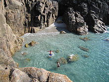
Church Rock, Penwith

Church Rock, Penwith

Church Rock is a beach on the west coast of Cornwall, UK. It is close to St Just in Penwith.

Access is via Porth Nanven beach, 500m along the coast to the north. At high tide access is a difficult climb down the cliff.

Coordinates: 50°07′02″N 5°42′05″W / 50.11731°N 5.70138°W / 50.11731; -5.70138


Wikimedia Foundation. 2010.

Игры ⚽ Поможем решить контрольную работу

Look at other dictionaries:

  • Church Rock — may refer to the following: Church Rock is an island in Barnstable County, Massachusetts, USA. Church Rock is an island in Bristol County, Massachusetts, USA. Church Rock, Penwith is a beach in Cornwall, United Kingdom. Church Rock (Utah) is a… …   Wikipedia

  • List of places in Penwith — This is a full list of all the towns, villages, hamlets and other places of note in the Penwith district of Cornwall, United KingdomA DBattery Rocks, Penzance, Bejouans, Boscaswell, Boscawen Un, Bosporthennis, Bosvennen, Boswednack, Botreah,… …   Wikipedia

  • Diocese of Truro — Location Ecclesiastical province Canterbury Archdeaconries Bodmin, Cornwall Coordinates …   Wikipedia

  • Civil parishes in Cornwall — A map of Cornwall (Cornish: Kernow); the Isles of Scilly (Cornish: Enesek Syllan) are in the extreme bottom left. A civil parish is a subnational entity, forming the lowest unit of local government in Engla …   Wikipedia

  • Cornwall — For other uses, see Cornwall (disambiguation). Cornwall Kernow Flag Motto of County Council: Onen …   Wikipedia

  • Hayle — Infobox UK place official name=Hayle country=England region=South West England|map type= Cornwall static static image caption= population=8,317 (2001 Census) os grid reference=SW561371 latitude=50.183 longitude= 5.416 london distance= post… …   Wikipedia

  • Heamoor — (formerly Hea) is a village in the Penwith district of Cornwall, England, United Kingdom. Formerly a secondary settlement of the village of Madron, Heamoor now forms a substantial part of the residential population of Penzance and is considered… …   Wikipedia

  • Mining in Cornwall and Devon — Ruin of Cornish tin mine …   Wikipedia

  • Marazion — For the Royal Navy warship, see HMS Marazion (1919). Coordinates: 50°07′31″N 5°28′33″W / 50.125278°N 5.475833°W / 50.125278; 5.475833 …   Wikipedia

  • United Kingdom — a kingdom in NW Europe, consisting of Great Britain and Northern Ireland: formerly comprising Great Britain and Ireland 1801 1922. 58,610,182; 94,242 sq. mi. (244,100 sq. km). Cap.: London. Abbr.: U.K. Official name, United Kingdom of Great… …   Universalium

Share the article and excerpts

Direct link
Do a right-click on the link above
and select “Copy Link”