- Cloghane
-
An Clochán
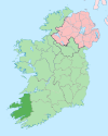
Cloghane— Village — 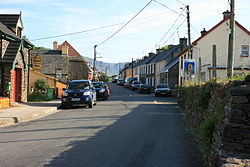 Location in Ireland
 An Clochán
Coordinates: 52°13′49″N 10°11′45″W / 52.23041°N 10.19574°WCoordinates: 52°13′49″N 10°11′45″W / 52.23041°N 10.19574°W Country Ireland Province Munster County County Kerry Population (2010) - Total ? Irish Grid Reference Q505112 An Clochán is the only official name. An Clochán (anglicized as Cloghane)[1] is a village and townland on the Dingle Peninsula of County Kerry, Ireland, at the foot of Mount Brandon. In 1974 the village was added to the Corca Dhuibhne Gaeltacht (Irish-speaking region).[2]
Cloghane and Brandon (An Clochán agus Cé Bhréanainn) are jointly twinned with the village of Plozévet in Brittany (France).
See also
References
- ^ A. D. Mills, 2003, A Dictionary of British Place-Names, Oxford University Press
- ^ S.I. No. 192/1974 — Gaeltacht Areas Order, 1974
Places in County Kerry County town: Tralee Towns Ballybunion · Cahersiveen · Castleisland · Dingle (Daingean Uí Chúis) · Kenmare · Killarney · Killorglin · Listowel · Tralee
Parishes,
Villages and
TownlandsAbbeydorney · Annascaul · Ardfert · Baile na nGall · Ballinskelligs · Ballyduff · Ballyferriter · Ballyheigue · Ballylongford · Ballymacelligott · Ballyseedy · Blennerville · Brandon Creek · Brandon · Brosna · Caherboshina · Caherdaniel · Castlecove · Castlegregory · Castlemaine · Causeway · Cloghane · Coolgarriv · Currans · Currow · Derrymore · Derrynane · Duagh · Dunquin · Fahamore · Farranfore · Fenit · Feothanach · Finuge · Fossa · Gneeveguilla · Kilderry · Kilflynn · Kilgarvan · Kilmoyley · Knightstown · Knocknagoshel · Lispole · Lisselton · Lixnaw · Milltown · Moyvane · Portmagee · Rathmore · Scraggane · Sneem · Tarbert · Tarmon · Templenoe · Tuosist · Ventry · Waterville · Valentia Island
List of townlands in County Kerry · Category:Geography of County Kerry Categories:- Towns and villages in County Kerry
- Gaeltacht towns and villages
- Gaeltacht places in County Kerry
- County Kerry geography stubs


Wikimedia Foundation. 2010.