- Moira, Leicestershire
-
Coordinates: 52°44′10″N 1°32′06″W / 52.736°N 1.535°W
Moira 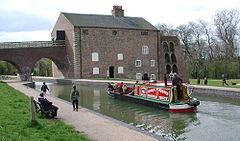
Moira Furnace and the
Ashby de la Zouch Canal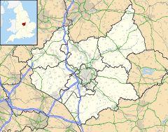
 Moira
Moira
Moira shown within LeicestershireOS grid reference SK315155 Parish Ashby Woulds District North West Leicestershire Shire county Leicestershire Region East Midlands Country England Sovereign state United Kingdom Post town Swadlincote Postcode district DE12 Dialling code 01530 Police Leicestershire Fire Leicestershire Ambulance East Midlands EU Parliament East Midlands UK Parliament North West Leicestershire Website Ashby Woulds Town Council List of places: UK • England • Leicestershire Moira is a former mining village about 2.5 miles (4 km) west of Ashby-de-la-Zouch in North West Leicestershire, England. The village is about 3 miles (5 km) miles south of the Derbyshire town of Swadlincote and is close to the county boundary.
Moira's toponym is derived from the Irish earldom of Moira, one of the titles of the Hastings family, which held castle. The former local colliery, Rawdon Colliery, also bore a Hastings family name. Moira is one of the few place names in England to end in an "a".
For centuries North West Leicestershire has been quarried and mined for coal, limestone, granite and brick clay, and its environmental damage was one of the reasons that it was chosen as the site for the National Forest, which is part of a Government-funded programme to create more woodland.
Contents
History
The Midland Railway opened its Leicester to Burton upon Trent Line through Moira in 1845. Moira railway station served the village until British Railways closed it in 1964. The building still survives and the line remains open as a freight route.
Rawdon Colliery was worked for about 150 years. Its seams extended 6 miles (10 km) from the shaft,and some had been worked twice, recovering lower grade coal. The pit survived Britain's pit closure programme in the mid-1980s that followed the miners' strike, but ran out of viable coal seams. Gases were rarely a hazard, but spontaneous combustion of coal dust was a potential problem.
Amenities
The 120 acres (49 ha) National Forest Millennium Discovery Centre, now called Conkers, is on the site of Rawdon Colliery. Its visitor centre features a borehole-based heating and cooling system. Moira Junction Local Nature Reserve occupies 8.5 acres (3.4 ha) of former railway sidings nearby.[1]
Moira Furnace is a restored 19th century blast furnace. A 1.5 miles (2.4 km) section of the Ashby Canal adjacent to the furnace has also been restored and refilled, although it lacks a navigable link to the rest of the system due to the A42 road having been built across its line. The furnace site also includes craft workshops and a small nature reserve.
Both the Youth Hostels Association's National Forest youth hostel and the Camping and Caravanning Club's National Forest campsite are in Moira and opened in 2008.[citation needed]
References
- ^ "Local Nature Reserve". Natural England. http://www.lnr.naturalengland.org.uk/Special/lnr/lnr_details.asp?C=0&N=moira&ID=1390. Retrieved 3 February 2011.
External links
Categories:- Villages in Leicestershire


Wikimedia Foundation. 2010.