- Meland
-
Meland kommune — Municipality — 

Coat of arms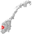
Hordaland within
NorwayMeland within Hordaland
Coordinates: 60°33′51″N 5°7′7″E / 60.56417°N 5.11861°ECoordinates: 60°33′51″N 5°7′7″E / 60.56417°N 5.11861°E Country Norway County Hordaland District Nordhordland Administrative centre Frekhaug Government - Mayor (2007) Nils Marton Aadland (H) Area - Total 93 km2 (35.9 sq mi) - Land 87 km2 (33.6 sq mi) Area rank 391 in Norway Population (2009) - Total 6,478 - Rank 172 in Norway - Density 66/km2 (170.9/sq mi) - Change (10 years) 20.2 % Demonym Melandsbu[1] Time zone CET (UTC+1) - Summer (DST) CEST (UTC+2) ISO 3166 code NO-1256 Official language form Nynorsk Website meland.kommune.no Data from Statistics Norway Historical populations Year Pop. ±% 1951 1,930 — 1960 1,721 −10.8% 1970 2,694 +56.5% 1980 3,508 +30.2% 1990 4,534 +29.2% 2000 5,353 +18.1% 2010 6,613 +23.5% 2020 7,862 +18.9% 2030 9,056 +15.2% Source: Statistics Norway. Meland is a municipality in the county of Hordaland, Norway.
Contents
History
The municipality is named after the farm of Meland. The norse name of the farm was "Meðalland". "Meðal" means "middle", while "land" means "farm" or "land",[2] so that the name as a whole roughly means "the farm that is located in the middle".[3]
Meland municipality was created when it was separated from Alversund municipality on 15 October 1923. Meland was one of many municipalities that were created for geographical reasons: the future municipality was separated from the rest of Alversund by the fjord, and transportation between the different parts of the municipality was unreliable and time-consuming. The creation of the municipality was approved in 1922, and the first election for the municipal council was held 23 August 1923. Meland encompassed all of Holsnøy except for the northernmost part, which belonged to Herdla municipality. An area in the north-east of Askøy also belonged to Meland municipality.[4]
In 1962, the Schei Committee concluded its survey of the organization of Norway's municipalities. The committee recommended enlarging Meland municipality, transferring the northern part of Holsnøy as well as the minor island of Øpsøy from Herdla municipality to Meland, as well as Flatøy and Håøy from Hamre municipality. Simultaneously, Meland would lose the parts of the municipality located on Askøy to Askøy municipality. Hordaland county approved the move, and the border changes came into effect on 1 January 1964.[5] A proposal to change the name of Meland municipality to "Holsenøy" was rejected.[6] Hamre and Herdla municipalities ceased to exist, and their territory was divided between Lindås, Osterøy and Meland, and Askøy, Øygarden and Meland, respectively.[7]
Geography
Meland consists of a number of islands. The largest is Holsnøy, which has an area of 89 km2, out of a total area of 93 km2 for the entire municipality. Holsnøy is located between Radøy and Lindås to its north, Åsane in Bergen to its east, Askøy to its south and the archipelago of Øygarden to its west. It is surrounded by fjords, namely (clockwise from north) Mangersfjorden, Radfjorden, Salhusfjorden, Herdlefjorden and Hjeltefjorden. The second largest island is Flatøy, located west of Holsnøy. The municipality also encompasses a number of minor islands.[3]
The administration centre of the municipality is Frekhaug, which is its largest settlement. Frekhaug is located in the south-eastern part of Holsnøy, and its urban area had a population of 1688 as of 2009. An additional two urban areas are located in the municipality: Krossneset on Flatøy (population 446) and Holme (population 646).[8]
Transport
As an island municipality, the road network of Meland depends upon bridges. The Nordhordland Bridge, which spans Salhusfjorden between Flatøy and Klauvaneset in Bergen, connects Meland to the mainland. The bridge is the main road northwards from Bergen, and is part of European route E39. The Krossnessundet Bridge, which is part of Rv 564, connects Flatøy to Holsnøy, the largest island of the municipality. The Krossnessundet Bridge opened in 1977,[9] while the Nordhordland Bridge dates from 1994.[10]
References
- ^ "Personnemningar til stadnamn i Noreg" (in Norwegian). Språkrådet. http://www.sprakrad.no/nb-no/Sprakhjelp/Rettskrivning_Ordboeker/Innbyggjarnamn/.
- ^ Stemshaug, Ola; Sandnes, Jørn; Aune, Kolbjørn (1990) (in Norwegian). Norsk stadnamnleksikon (3 ed.). Oslo: Det Norske Samlaget. pp. 218. ISBN 82-521-3477-7.
- ^ a b Hartvedt, Gunnar Hagen (1994). "Meland" (in Norwegian). Bergen Byleksikon. Oslo: Kunnskapsforlaget. pp. 35. ISBN 8257304859.
- ^ Flatøy, Olav (1973) (in Norwegian). Meland kommune gjennom 50 år : 1923-1973. Meland: Meland kommune. pp. 23–26. ISBN 82-990268-0-6.
- ^ Juvkam, Dag (May 1999). "Historisk oversikt over endringer i kommune- og fylkesinndelingen" (in Norwegian). Statistics Norway. http://www.ssb.no/emner/00/90/rapp_9913/rapp_9913.pdf. Retrieved 2009-11-15.
- ^ Flatøy, Olav (1973) (in Norwegian). Meland kommune gjennom 50 år : 1923-1973. Meland: Meland kommune. pp. 60–61. ISBN 82-990268-0-6.
- ^ Flatøy, Olav (1973) (in Norwegian). Meland kommune gjennom 50 år : 1923-1973. Meland: Meland kommune. pp. 15–17. ISBN 82-990268-0-6.
- ^ Statistics Norway (2009). Urban settlements. Population and area, by municipality. 1 January 2009. http://www.ssb.no/english/subjects/02/01/10/beftett_en/tab-2009-06-16-01-en.html.
- ^ Kortner, Olaf; Munthe, Preben; Tveterås, Egil (1994) (in Norwegian). Aschehoug og Gyldendals store norske leksikon. K-Lat. Aschehoug, Gyldendal. pp. 529. ISBN 82-573-0583-9.
- ^ "Structurae [en: Nordhordland Bridge (1994)"]. Structurae. http://en.structurae.de/structures/data/index.cfm?ID=s0004000. Retrieved 2009-11-15.
Municipalities of Hordaland Nordhordland 
Voss Hardanger Midthordland Sunnhordland Categories:- Municipalities of Hordaland


Wikimedia Foundation. 2010.