- Bømlo
-
Bømlo kommune — Municipality — 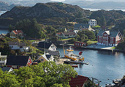

Coat of arms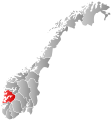
Hordaland within
NorwayBømlo within Hordaland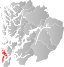
Coordinates: 59°46′46″N 5°13′6″E / 59.77944°N 5.21833°ECoordinates: 59°46′46″N 5°13′6″E / 59.77944°N 5.21833°E Country Norway County Hordaland District Sunnhordland Administrative centre Svortland Government – Mayor (2003) Inge Reidar Kallevåg (H) Area – Total 246 km2 (95 sq mi) – Land 235 km2 (90.7 sq mi) Area rank 307 in Norway Population (2009) – Total 11 189 – Density 46/km2 (119.1/sq mi) – Change (10 years) 5.7 % Demonym Bømling[1] Time zone CET (UTC+1) – Summer (DST) CEST (UTC+2) ISO 3166 code NO-1219 Official language form Nynorsk Website www.bomlo.kommune.no Data from Statistics Norway Historical populations Year Pop. ±% 1951 7,745 — 1961 8,104 +4.6% 1971 8,276 +2.1% 1981 9,258 +11.9% 1991 9,727 +5.1% 2001 10,839 +11.4% 2011 11,421 +5.4% Source: Statistics Norway. 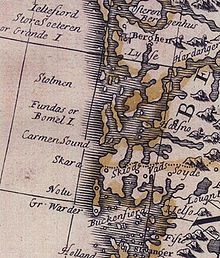 A 1720 map showing "Fundas or Bomel I."
Bømlo is a municipality in Sunnhordland, in the southern part of the county of Hordaland, Norway. It is also the name of the main island of this archipelago, consisting of about 900 islets, located west of Stord.
The old municipality of Finnås was divided into Bømlo, Bremnes, and Moster on 1 July 1916. The two latter municipalities were merged back into Bømlo on 1 January 1963.
Bømlo was also involved in the Shetland bus operation in WWII.
Contents
General information
Name
The municipality is named after the main island of Bømlo (Norse Bymbil). The meaning of the name is unknown. Until 1918 the name was written Bømmel.
Coat-of-arms
The coat-of-arms is from modern times. They were granted on 29 February 1980. The arms show a water lily leaf with a trefoil. The trefoil symbolizes the three former municipalities Bremnes, Moster, and Bømlo, which were united in 1963. The water lily leaf was simply chosen as a decorative element without any further significance.[2]
Locations
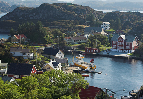
Bømlo is commonly distinguished into different areas of where people reside. These areas include Svortland(earlier called Bremnes), Moster, Søra-Bømlo (South-Bømlo), Rubbestadneset, Finnås, Gilje, Goddo, and Hiskjo. Svortland is the financial center with stores, a culture house, schools and official buildings and is located a bit north on the island. Moster is on the other hand more to the east with a high percentage of devout Christians residing in three different sects. Bømlos economy is in a large degree sustained by Eidesvik Shipping, Wärtsila, fishindustry, tourism and general offshore related work.
Culture
Bømlo is known in the region for several shows and musicals performed in Moster Amfi. The local community is very active in culture work be it song, dance or the active Christian community. Traditionally Bømlos culture has centered around Christianity with its pinnacle: "Mostraspelet". A play conducted in Moster Amfi surrounding the topic of how Christianity came to Norway via Bømlo late during the first millennium. In Moster , Bømlo Musical Laug has staged several musicals.
Sports
Soccer is the most popular sport played by the male population on the island. Notable soccer player like Arne Larsen Økland, Geirmund Brendesæter and Gunnar Meling started their careers in Bremnes IL. The former top player and current coach for Brann IL Mons Ivar Mjelde had a brief stay at Moster IL.
Education
There are several schools in the area. The schools Svortland, Gilje, Meling, Folderøy, Våge, Håvik and Espevær only have students from 1st-7th grade. The schools Rubbestadneset, Moster and Hillestveit have students from 1st through 10th grade. Bremnes Ungdomsskule gathers most students from 8th to 10th grade. There are two upper secondary schools, Bømlo Vidaregåande skule and Rubbestadnes Vidaregåande Skule (earlier Rubbestadnes Yrkesskule)
There is also a Folk High School, Olavskulen Folkehøgskule
Industry
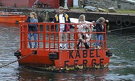 Chain ferry at Espevær
Wärtsilä , Eidesvik, Brandasund fiskeforedling and Bremnes Seashore are notable employers. As well as tourism.
Transport
An extensive tunnel and bridge system, the Triangle Link, connected Bømlo to the mainland and neighboring island Stord on 30 April 2001.
References
- ^ "Personnemningar til stadnamn i Noreg" (in Norwegian). Språkrådet. http://www.sprakrad.no/nb-no/Sprakhjelp/Rettskrivning_Ordboeker/Innbyggjarnamn/.
- ^ Norske Kommunevåpen (1990). "Nye kommunevåbener i Norden". http://www.ngw.nl/int/nor/b/bomlo.htm. Retrieved 21 September 2010.
External links
- Municipal fact sheet from Statistics Norway
- Hordaland travel guide from Wikitravel
- Municipality web site (Norwegian)
- Map
- Weather radar at Bømlo
- Bømlo tourist information
Municipalities of Hordaland Nordhordland 
Voss Hardanger Midthordland Sunnhordland Categories:- Municipalities of Hordaland
- Islands of Hordaland
- Archipelagoes of Norway


Wikimedia Foundation. 2010.