- Øygarden
-
Øygarden kommune — Municipality — 

Coat of arms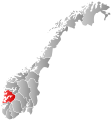
Hordaland within
NorwayØygarden within Hordaland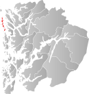
Coordinates: 60°36′39″N 4°49′29″E / 60.61083°N 4.82472°ECoordinates: 60°36′39″N 4°49′29″E / 60.61083°N 4.82472°E Country Norway County Hordaland District Midhordland Administrative centre Tjeldstø Government – Mayor (2003) Olav Martin Vik (Local List) Area – Total 67 km2 (25.9 sq mi) – Land 64 km2 (24.7 sq mi) Area rank 410 in Norway Population (2011) – Total 4,300 – Rank 232 in Norway – Density 62/km2 (160.6/sq mi) – Change (10 years) 15.8 % Demonym Øygarding[1] Time zone CET (UTC+1) – Summer (DST) CEST (UTC+2) ISO 3166 code NO-1259 Official language form Nynorsk Website www.oygarden.kommune.no Data from Statistics Norway Historical populations Year Pop. ±% 1951 1,050 — 1960 1,057 +0.7% 1970 2,835 +168.2% 1980 2,534 −10.6% 1990 3,158 +24.6% 2000 3,623 +14.7% 2010 4,269 +17.8% 2020 4,736 +10.9% 2030 5,237 +10.6% Source: Statistics Norway. Øygarden is a municipality in Hordaland county, Norway. It is located in the traditional district of Midhordland. The administrative centre is Rong.
Øygarden was created as a new municipality on 1 January 1964 after the merger of Hjelme and parts of Herdla.
The municipality consists of a chain of islands north of the municipality Fjell.
Contents
General information
The name
The name is the finite form of øygard which means "row (fence) of islands". The first element is øy means "island" and the last element is gard which means "fence".
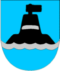
Coat-of-arms
The coat-of-arms is from modern times. They were granted in 1966. The arms show a black and gray reference seacairn placed on an islet on a blue background. The municipality consists of a number of islands and is dependent on the sea for its development. Hence the importance of sea cairns, buoys and lighthouses for safety in the municipality.[2]
References
- ^ "Personnemningar til stadnamn i Noreg" (in Norwegian). Språkrådet. http://www.sprakrad.no/nb-no/Sprakhjelp/Rettskrivning_Ordboeker/Innbyggjarnamn/.
- ^ Norske Kommunevåpen (1990). "Nye kommunevåbener i Norden". http://www.ngw.nl/int/nor/o/oygarden.htm. Retrieved 27 September 2008.
Municipalities of Hordaland Nordhordland 
Voss Hardanger Midthordland Sunnhordland Categories:- Municipalities of Hordaland
- Archipelagoes of Norway
- Hordaland geography stubs


Wikimedia Foundation. 2010.