- Nugal, Somalia
-
Nugal
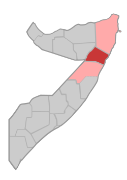
Nugaal— Region — Location in Somalia. Coordinates: 6°6′47″N 47°59′17″E / 6.11306°N 47.98806°ECoordinates: 6°6′47″N 47°59′17″E / 6.11306°N 47.98806°E Country  Somalia
Capital Garowe Time zone EAT (UTC+3) Nugal (Somali: Nugaal) is an administrative region (gobol) in northeastern Somalia.[1]
Contents
Overview
It is bordered by Ethiopia and the Somalian regions of Sool to the west, Bari to the north, and Mudug to the south, with the Indian Ocean to the east.
Nugaal is centered on Garowe, the capital of the autonomous Puntland macro-region.
A major geographic feature of the region is the Nugaal Valley, a large shallow drainage basin fed by the Nugal and Dheer seasonal rivers during the April-June rainy season.
Districts
The Nugaal region consists of four districts:[2]
- Burtinle District
- Dangoroyo District
- Eyl District
- Garoowe District
Major towns
- Burtinle
- Garowe
Notes
 Somalia
Capital: Mogadishu Topics Maritime history · Laas Gaal · Land of Punt · Walashma dynasty · Warsangali Sultanate · Adal Sultanate · Ajuuraan State · Dervish State · Gobroon Dynasty · Majeerteen Sultanate · Sultanate of Hobyo · Italian Somaliland · British Somaliland · Ogaden War · Somalian Revolution (1986–1992) · History of Somalia (1991–2006) · Somali Civil War · Unified Task Force · Piracy in Somalia · War in Somalia (2006–2009) · War in Somalia (2009–)Architecture · Art · Cinema · Cuisine · Languages · Literature · Music · Christianity · Islam · Sports · Coat of arms · Flag · National anthemPost-war divisions Declared statesIslamist administrationsFormer administrationsProposed statesPre-war divisions Awdal · Bakool · Banaadir · Bari · Bay · Galguduud · Gedo · Hiiraan · Jubbada Dhexe · Jubbada Hoose · Mudug · Nugaal · Sanaag · Shabeellaha Dhexe · Shabeellaha Hoose · Sool · Togdheer · Woqooyi GalbeedOutline · Index · Portal Categories:- Puntland
- Regions of Somalia
- Somalia geography stubs
Wikimedia Foundation. 2010.

