- Norwood, Arkansas
-
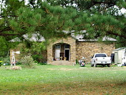
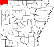
Norwood, Arkansas — Unincorporated community — Former Norwood School, September 2011 Norwood's position in Arkansas. Coordinates: 36°7′7″N 94°27′41″W / 36.11861°N 94.46139°WCoordinates: 36°7′7″N 94°27′41″W / 36.11861°N 94.46139°W Country  United States
State  Arkansas
County Benton Township 13 Elevation[1] 355 m (1,165 ft) Time zone Central (CST) (UTC-6) - Summer (DST) CDT (UTC-5) Zip Code 72704 Area code(s) 479 GNIS feature ID 75932 U.S. Geological Survey Geographic Names Information System: Norwood, Arkansas Norwood is an unincorporated community in Township 13, Benton County, Arkansas, United States.[2] It is located is south Benton County near the Washington County line on Arkansas Highway 16.[3] The community had a school which is now closed and listed on the National Register of Historic Places.
References
- ^ "Norwood, Arkansas". Histopolis. http://www.histopolis.com/Place/US/AR/Benton_County/Norwood. Retrieved 11 September 2011.
- ^ U.S. Geological Survey Geographic Names Information System: Norwood, Arkansas United States Geological Survey. Retrieved 11 September 2011.
- ^ DeLorme. Arkansas Atlas and Gazetteer (Map) (Second ed.). Section 22.
Municipalities and communities of Benton County, Arkansas County seat: Bentonville Cities Bentonville | Bethel Heights | Cave Springs | Centerton | Decatur | Elm Springs‡ | Gentry | Gravette | Little Flock | Lowell | Pea Ridge | Rogers | Siloam Springs | Springdale‡ | Sulphur Springs
Towns Avoca | Bella Vista | Garfield | Gateway | Highfill | Springtown
Townships 1 | 2 | 3 | 4 | 5 | 6 | 7 | 8 | 9 | 10 | 11 | 12 | 13
CDPs Cherokee City | Hiwasse | Lost Bridge Village | Maysville | Prairie Creek
Other
communitiesAccident | Apple Spur | Beacon Addition | Beaty | Beaver Shores | Bella Vista | Benton City | Blackjack Corner | Bland | Bloomfield | Brightwater | Clantonville | Clear Point | Creech | Cross Hollow | Dawn Hill | Dug Hill | Eagle Corner | Elkhorn Tavern | Fairmount | Falling Springs | Frisco | Gallatin | Glade | Green Acres | Healing Springs | Hickory Creek | Hico | Hill Top | Ionia | Lake Frances | Lakeland Hills | Larue | Leetown | Logan | Martin | Mason Valley | Miller | Monte Ne | Nebo | Norwood | Oak Grove | Osage Mills | Pedro | Pine Top | Pleasant Hill | Pleasant Ridge | Pleasure Heights | Rago | Rambo Riveria | Rivercliff Estates | Robinson | Rocky Comfort | Seba | Silent Grove | Spring Creek | Tanglewood | Twin Springs | Vaughn | Vista Shores | Walnut Hill | War Eagle | West Point
Ghost town Footnotes ‡This populated place also has portions in an adjacent county or counties
Categories:- Arkansas geography stubs
- Populated places in Benton County, Arkansas
- Unincorporated communities in Arkansas
Wikimedia Foundation. 2010.


