- Cherokee City, Arkansas
-
Cherokee City, Arkansas — Census-designated place — 
 Cherokee City, Arkansas
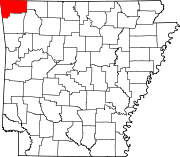
Coordinates: 36°17′54″N 94°34′40″W / 36.29833°N 94.57778°W Country United States State Arkansas County Benton Area[1] – Total 0.468 sq mi (1.2 km2) – Land 0.468 sq mi (1.2 km2) – Water 0 sq mi (0 km2) Elevation 1,155 ft (352 m) Population (2010)[2] – Total 72 – Density 153.8/sq mi (59.4/km2) Time zone Central (CST) (UTC-6) – Summer (DST) CDT (UTC-5) Area code(s) 479 GNIS feature ID 76597[3] Cherokee City is an unincorporated census-designated place in Benton County, Arkansas, United States. As of the 2010 census, its population is 72.[2] It is the location of (or is the nearest community to) Coon Creek Bridge, which is located on Cty Rd. 24 and is listed on the National Register of Historic Places.[4] The community was named for the Cherokee Indians, since the Trail of Tears crossed the landscape when the Cherokee migrated west to Indian territory, now Oklahoma in the late 1830s. The town is about 5 miles east of Oklahoma and 4 miles south of the Missouri state line.
References
- ^ "US Gazetteer files: 2010, 2000, and 1990". United States Census Bureau. 2011-02-12. http://www.census.gov/geo/www/gazetteer/gazette.html. Retrieved 2011-04-23.
- ^ a b "American FactFinder". U.S. Census Bureau. http://factfinder2.census.gov/main.html. Retrieved 26 April 2011.
- ^ U.S. Geological Survey Geographic Names Information System: Cherokee City, Arkansas
- ^ "National Register Information System". National Register of Historic Places. National Park Service. 2009-03-13. http://nrhp.focus.nps.gov/natreg/docs/All_Data.html.
Municipalities and communities of Benton County, Arkansas Cities Bentonville | Bethel Heights | Cave Springs | Centerton | Decatur | Elm Springs‡ | Gentry | Gravette | Little Flock | Lowell | Pea Ridge | Rogers | Siloam Springs | Springdale‡ | Sulphur Springs
Towns Avoca | Bella Vista | Garfield | Gateway | Highfill | Springtown
Townships 1 | 2 | 3 | 4 | 5 | 6 | 7 | 8 | 9 | 10 | 11 | 12 | 13
CDPs Cherokee City | Hiwasse | Lost Bridge Village | Maysville | Prairie Creek
Other
communitiesAccident | Apple Spur | Beacon Addition | Beaty | Beaver Shores | Bella Vista | Benton City | Blackjack Corner | Bland | Bloomfield | Brightwater | Clantonville | Clear Point | Creech | Cross Hollow | Dawn Hill | Dug Hill | Eagle Corner | Elkhorn Tavern | Fairmount | Falling Springs | Frisco | Gallatin | Glade | Green Acres | Healing Springs | Hickory Creek | Hico | Hill Top | Ionia | Lake Frances | Lakeland Hills | Larue | Leetown | Logan | Martin | Mason Valley | Miller | Monte Ne | Nebo | Norwood | Oak Grove | Osage Mills | Pedro | Pine Top | Pleasant Hill | Pleasant Ridge | Pleasure Heights | Rago | Rambo Riveria | Rivercliff Estates | Robinson | Rocky Comfort | Seba | Silent Grove | Spring Creek | Tanglewood | Twin Springs | Vaughn | Vista Shores | Walnut Hill | War Eagle | West Point
Ghost town Footnotes ‡This populated place also has portions in an adjacent county or counties
Coordinates: 36°17′54″N 94°34′40″W / 36.29833°N 94.57778°W
Categories:- Populated places in Benton County, Arkansas
- Census-designated places in Arkansas
- Arkansas geography stubs


Wikimedia Foundation. 2010.