- Norman Wells
-
Norman Wells
Tłegǫ́hłı̨
The Wells— Town — Norman Wells from the air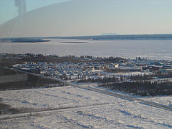
Motto: Where Adventures Begin 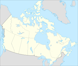
 Norman Wells
Coordinates: 65°16′52″N 126°49′53″W / 65.28111°N 126.83139°WCoordinates: 65°16′52″N 126°49′53″W / 65.28111°N 126.83139°W Country  Canada
Territory  Northwest Territories
Region Sahtu Region Constituency Sahtu Census division Inuvik Region, Northwest Territories Incorporated (town) 12 April 1992 Government - Mayor Dudley Johnson - Senior Administrative Officer Ian Fremantle - MLA Norman Yakeleya Area - Land 93.28 km2 (36 sq mi) Elevation 73 m (240 ft) Population - Total 761 - Density 8.2/km2 (21.2/sq mi) Time zone Mountain (MST) (UTC-7) - Summer (DST) MDT (UTC-6) Canadian Postal code X0E 0V0 Area code(s) 867 Telephone exchange 587 Prices - Living cost 152.5A - Food price index 187.1B Website www.normanwells.com Sources:
Community Governance Data List[1]
2006 Canada Census[2],
Prince of Wales Northern Heritage Centre[3],
Canada Flight Supplement[4]
^A 2005 figure based on Edmonton = 100[5]
^B 2004 figure based on Yellowknife = 100[5]Norman Wells (Slavey language: Tłegǫ́hłı̨ "where there is oil") is the regional centre for the Sahtu Region of the Northwest Territories, Canada. The town is situated on the north side of the Mackenzie River and provides a view down the valley of the Franklin and Richardson Mountains.[6]
Contents
Demographics
Historical populations Year Pop. %± 1996 840 – 1997 808 -3.8% 1998 826 2.2% 1999 747 -9.6% 2000 755 1.1% 2001 766 1.5% 2002 747 -2.5% 2003 795 6.4% 2004 836 5.2% 2005 823 -1.6% 2006 805 -2.2% 2007 847 5.2% 2008 832 -1.8% 2009 800 -3.8% Sources: NWT Bureau of Statistics[5] According to the 2006 Census the town has a population of 761, which is a decrease of 1.8% from the revised 2001 Census figure of 775.[7] 300 people identified as aboriginal,[2] and of these, 165 were First Nations, 110 were Métis and 25 were Inuit.[8] In 2009 the Government of the Northwest Territories reported that the population was 800 with an average yearly growth rate of -0.4 from 1996.[5]
The main languages in the town are North Slavey and English.[6]
Of the population, 75.7% is 15 and older, with the median age being 31, slightly less than the NWT averages of 76.1% and 31.2.[2]
History
Oil was first seen by Alexander MacKenzie during his exploration of the river in 1789 but it was not until 1911 that an oil bearing formation was discovered. Imperial Oil, a major employer in the town, was established in the area in 1937 with a refinery built in 1937.[6]
During the Second World War, Norman Wells was deemed important as a source of oil for military operations in Alaska and the Yukon. The Canol Road and pipeline project was undertaken to enable the piping of oil to Whitehorse, with the flow starting in 1944. Although Norman Wells crude was light and easily flowed at temperatures as low as -62 °C (-80 °F), the line did not work well and was shut down shortly after the war ended. The road, which began at Canol Camp across the river, was abandoned.[6][9] The Canol Heritage Trail is what remains of the road in the NWT.
The Norman Wells Proven Area Agreement of 1944 is a partnership between Imperial Oil and the federal government (administered by the Indian and Northern Affairs Canada) that has lasted to this day. The completion of an oil pipeline from Norman Wells to Zama City resulted in increased activity.
First Nations
The Norman Wells Metis, an Métis group which is signatory to the Sahtu Dene and Metis Comprehensive Land Claim Agreement, are currently negotiating self-government powers and recently signed a framework agreement towards a new treaty.
Transportation
Norman Wells is accessible by navigating the Mackenzie River, in summer, or by driving over the winter ice road, December to March, that connects with Wrigley and Fort Simpson.[6] The most common method of travel into Norman Wells is by air via the Norman Wells Airport and the town is connected with both Yellowknife and Inuvik.[6] Scheduled flights are provided by Canadian North and North-Wright Airways. Beginning in June 2010, First Air offered a scheduled service into the community. In the summer floatplane access to the town is possible at the Norman Wells Water Aerodrome. There is an annual sealift to the town by Northern Transportation Company Limited from Hay River.[6] Other aviation companies that have a presence in the community include Canadian Helicopters and Sahtu Helicopters.[10]
Services
Services include a three member Royal Canadian Mounted Police detachment and a health centre with three nurses and a dental clinic. There is a branch of the Canadian Imperial Bank of Commerce and two grocery stores including the Northern and Rampart Rentals along with four hotels and six restaurants. Norman Wells also has a Liquor Store and currently has the only one in the Sahtu region. Phone service is provided by Northwestel with cable or dial up Internet access available.[11] Mobile phone services are available through NMI Mobility or Northwestel's Latitude Wireless service.[12][13] Former Member of Parliament for the Western Arctic, Ethel Blondin-Andrew, has a consulting service, Mountain Dene Ventures, in the town.[10]
Education
The community is part of the Sahtu Divisional Education Council and they operate, through the Norman Wells District Education Authority, the "Mackenzie Mountain School".[14][15] The school, which has an enrollment of 150, provides education from Kindergarten to Grade 12.[16][17] Aurora College has a presence in the community with a community learning centre and a career centre.[12][13]
Climate
Norman Wells has a subarctic climate with summer lasting for about three months. Although winter temperatures are usually below freezing, every month of the year has seen temperatures above zero. Rainfall averages 166.0 millimetres (6.54 in) and snowfall 153.4 centimetres (60.39 in). On average, there are 102.5 days, October to April, when the wind chill is below -30, which indicates that frostbite may occur within 10 – 30 minutes. There is an average of 44.6 days, November to April, when the wind chill is below -40, which indicates that that frostbite may occur within 5 – 10 minutes.[18][19]
Climate data for Norman Wells Airport, NWT Month Jan Feb Mar Apr May Jun Jul Aug Sep Oct Nov Dec Year Record high °C (°F) 11.8
(53.2)7.9
(46.2)11.1
(52.0)20.0
(68.0)31.1
(88.0)33.5
(92.3)35.0
(95.0)32.4
(90.3)27.1
(80.8)20.8
(69.4)13.3
(55.9)5.7
(42.3)35.0
(95.0)Average high °C (°F) −22.6
(−8.7)−20.2
(−4.4)−12.5
(9.5)0.3
(32.5)12.3
(54.1)20.7
(69.3)22.6
(72.7)19.2
(66.6)11.1
(52.0)−2.1
(28.2)−15.8
(3.6)−21.2
(−6.2)−0.7 Daily mean °C (°F) −26.5
(−15.7)−24.7
(−12.5)−18.4
(−1.1)−5.8
(21.6)6.5
(43.7)15.0
(59.0)17.0
(62.6)13.8
(56.8)6.6
(43.9)−5.3
(22.5)−19.3
(−2.7)−25.1
(−13.2)−5.5 Average low °C (°F) −30.4
(−22.7)−29.2
(−20.6)−24.3
(−11.7)−11.9
(10.6)0.7
(33.3)9.2
(48.6)11.3
(52.3)8.3
(46.9)1.9
(35.4)−8.4
(16.9)−22.9
(−9.2)−28.9
(−20.0)−10.4 Record low °C (°F) −52.2
(−62.0)−54.4
(−65.9)−46.1
(−51.0)−37.2
(−35.0)−17.8
(0.0)−2.8
(27.0)−1.1
(30.0)−6.1
(21.0)−15.7
(3.7)−31.7
(−25.1)−42.8
(−45.0)−47.8
(−54.0)−54.4
(−65.9)Precipitation mm (inches) 17.0
(0.669)13.6
(0.535)11.5
(0.453)11.9
(0.469)21.0
(0.827)40.8
(1.606)41.0
(1.614)41.6
(1.638)31.2
(1.228)26.5
(1.043)16.4
(0.646)18.2
(0.717)290.7
(11.445)Sunshine hours 26.9 75.6 167.6 230.0 292.6 n/a n/a 238.0 126.1 53.7 n/a 7.3 n/a Source no. 1: Environment Canada[20] Source no. 2: Sunshine data from 1961-1990 Environment Canada [21] References
- ^ Community Governance Data List
- ^ a b c Canada Census, Norman Wells
- ^ Prince of Wales Northern Heritage Centre - official names
- ^ Canada Flight Supplement. Effective 0901Z 20 October 2011 to 0901Z 15 December 2011
- ^ a b c d Norman Wells - Statistical Profile at the GNWT
- ^ a b c d e f g Legislative Assembly of the Northwest Territories, Norman Wells profile
- ^ Population and dwelling count amendments
- ^ Aboriginal identity population by age groups, median age and sex, 2006 counts, for Canada, provinces and territories, and census subdivisions (municipalities) - 20% sample data
- ^ Norman Wells, Bureau of Statistics
- ^ a b Doing Business in Norman Wells
- ^ [1]
- ^ a b Northwestel
- ^ a b Infrastructure
- ^ Sahtu Divisional Education Council
- ^ Community Groups
- ^ Mackenzie Mountain School at the SDEC
- ^ Official school site
- ^ Wind Chill Hazards and Risk of Frostbite
- ^ "Canadian Climate Normals 1971-2000". http://www.climate.weatheroffice.ec.gc.ca/climate_normals/results_e.html?Province=NWT%20&StationName=&SearchType=&LocateBy=Province&Proximity=25&ProximityFrom=City&StationNumber=&IDType=MSC&CityName=&ParkName=&LatitudeDegrees=&LatitudeMinutes=&LongitudeDegrees=&LongitudeMinutes=&NormalsClass=A&SelNormals=&StnId=1680&. Retrieved 15 March 2008.
- ^ Environment Canada—Canadian Climate Normals 1971–2000. Retrieved 17 June 2011.
- ^ Environment Canada—Canadian Climate Normals 1961–1990. Retrieved 22 June 2011.
External links
- NormanWells.com
- 1920 The Discovery of Oil NWT Historical Timeline, Prince of Wales Northern Heritage Centre
 Subdivisions of the Northwest Territories
Census divisions Dehcho Region Inuvik Region Aklavik · Fort McPherson · Inuvik · Paulatuk · Sachs Harbour · Tsiigehtchic · Tuktoyaktuk · UlukhaktokNorth Slave Region Sahtu Region South Slave Region Enterprise · Fort Providence · Fort Resolution · Fort Smith · Hay River Reserve · Hay River · KakisaCategories:- Communities in the Sahtu Region
- Towns in the Northwest Territories


Wikimedia Foundation. 2010.