- Nong Chok District
-
Nong Chok
หนองจอก— Khet — Khet location in Bangkok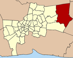
Coordinates: 13°51′20″N 100°51′45″E / 13.85556°N 100.8625°ECoordinates: 13°51′20″N 100°51′45″E / 13.85556°N 100.8625°E Country  Thailand
Province Bangkok Seat Krathum Rai Khwaeng 8 Amphoe established Area - Total 236.261 km2 (91.2 sq mi) Population (2004) - Total 117,385 - Density 497/km2 (1,287.2/sq mi) Time zone THA (UTC+7) Postal code 10530 Geocode 1003 Nong Chok (Thai: หนองจอก; IPA: [nɔ̌ːŋ tɕɔ̀ːk]) is one of the 50 districts (Khet) of Bangkok, Thailand. It is bounded by other districts (from north clockwise): Amphoe Lam Luk Ka of Pathum Thani Province, Amphoe Bang Nam Priao and Amphoe Mueang Chachoengsao of Chachoengsao Province, Lat Krabang, Min Buri and Khlong Sam Wa of Bangkok. It is the biggest and the least populated district of Bangkok.
Contents
History
The district was established as an amphoe in 1897 during King Chulalongkorn period. The original settlers were muslims relocated from cities in southern Thailand. In 1902, it became an amphoe of the newly setup Min Buri Province. Due to economic hardship during 1930-31, Min Buri Province was disbanded in 1931 and Nong Chok was transferred to Chachoengsao Province. However the administration was moved under Bangkok the next year due to inconveniece of travel between Nong Chok and Chachoengsao. Today about 75 percent of the population remains Muslims while 22 percent are buddhists. The name Nong Chok means water lettuce (Pistia stratiotes) swamp.
Economy
Agriculture was and remains the most important part of Nong Chok economy. Rice, vegetables, fruits, and livestocks are main products. It is famous for its gamecocks and birdcages. Lots of canals were dug for irrigation and transportation.
Places
Administration
The district is sub-divided into eight sub-districts (Khwaeng).
- Krathum Rai (กระทุ่มราย)
- Nong Chok (หนองจอก)
- Khlong Sip (คลองสิบ)
- Khlong Sip Song (คลองสิบสอง)
- Khok Faet (โคกแฝด)
- Khu Fang Nuea (คู้ฝั่งเหนือ)
- Lam Phak Chi (ลำผักชี)
- Lam Toiting (ลำต้อยติ่ง)
External links
Districts (khet) of Bangkok West of the
Chao PhrayaBang Bon · Bang Khae · Bang Khun Thian · Bangkok Noi · Bangkok Yai · Bang Phlat · Chom Thong · Khlong San · Nong Khaem · Phasi Charoen · Rat Burana · Taling Chan · Thawi Watthana · Thon Buri · Thung Khru
East of the
Chao PhrayaBang Kapi · Bang Khen · Bang Kho Laem · Bang Na · Bang Rak · Bang Sue · Bueng Kum · Chatuchak · Din Daeng · Don Mueang · Dusit · Huai Khwang · Khan Na Yao · Khlong Sam Wa · Khlong Toei · Lak Si · Lat Krabang · Lat Phrao · Min Buri · Nong Chok · Pathum Wan · Phaya Thai · Phra Khanong · Phra Nakhon · Pom Prap Sattru Phai · Prawet · Ratchathewi · Samphanthawong · Sai Mai · Saphan Sung · Sathon · Suan Luang · Wang Thonglang · Watthana · Yan Nawa
Categories:- Districts of Bangkok


Wikimedia Foundation. 2010.