- Min Buri District
-
Min Buri
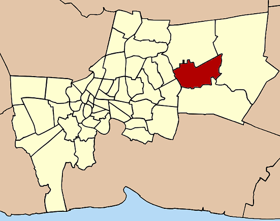
มีนบุรี— Khet — Khet location in Bangkok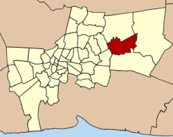
Coordinates: 13°48′50″N 100°44′53″E / 13.81389°N 100.74806°ECoordinates: 13°48′50″N 100°44′53″E / 13.81389°N 100.74806°E Country  Thailand
Province Bangkok Seat Min Buri Khwaeng 2 Amphoe established Area - Total 63.645 km2 (24.6 sq mi) Population (2004) - Total 115,212 - Density 1,810/km2 (4,687.9/sq mi) Time zone THA (UTC+7) Postal code 10510 Geocode 1010 Min Buri (Thai: มีนบุรี; IPA: [mīːn būrīː]) is one of the 50 districts (Khet) of Bangkok, Thailand. It is bounded by other Bangkok districts (from north clockwise): Khlong Sam Wa, Nong Chok, Lat Krabang, Saphan Sung, and Khan Na Yao.
Contents
History
The district was once a province established in 1901 during King Chulalongkorn period consisting of Amphoe Khlong Sam Wa, Amphoe Saen Saep, Amphoe Nong Chok, and Amphoe Chia Radap (เจียรดับ). The name Min Buri (meaning city of fish) was chosen to go with the existing Thanyaburi Province (meaning city of rice). Economic problems during 1930-31 caused the government to disband various organizations to reduce expenses. The Min Buri Province was also eliminated and turned into Amphoe Min Buri and Amphoe Lat Krabang of Bangkok, and Amphoe Nong Chok of Chachoengsao Province. In 1957 part of Saen Saep subdistrict of Lat Krabang were transferred to Min Buri. And finally in 1997, the northern part of Min Buri were split out to form the new Khlong Sam Wa district.
Administration
The district is sub-divided into two sub-districts (Khwaeng).
1. Min Buri มีนบุรี 2. Saen Saep แสนแสบ District Council
The District Council for Min Buri has seven members, who each serve four-year terms. Elections were last held on April 30, 2006. The results were as follows:
- Democrat Party - 7 seats
Places
Museums
- Minburi Local Museum (Former Minburi City Hall)
- Small Barge Museum
Markets
- Minburi Old Market
- Chatuchak Weekend Market 2 Minburi
Pubilc Park
- Rama IX Commemoration Park (สวนเฉลิมพระเกียรติ ร.9 มีนบุรี)
Temples
- Wat Bang Pheng Tai (วัดบางเพ็งใต้)
- Wat Bamphen Nuea (วัดบำเพ็ญเหนือ)
- Wat Saen Suk (วัดแสนสุข)
Education
- Kasem Bundit University Romklao Campus
- Minburi Discovery Learning Library
- Setthabutbamphen School
- Satrisetthabutbamphen School
- Minburi Technical College
- Minprasatwittaya School
Sports
- Minburi Sports Complex Commemorating HM the Queen's 72nd birthday anniversary (ศูนย์กีฬาเฉลิมพระเกียรติ 72 พรรษา มีนบุรี)
Industrial Estate
- Bangchan Industrial Estate
External links
Districts (khet) of Bangkok West of the
Chao PhrayaBang Bon · Bang Khae · Bang Khun Thian · Bangkok Noi · Bangkok Yai · Bang Phlat · Chom Thong · Khlong San · Nong Khaem · Phasi Charoen · Rat Burana · Taling Chan · Thawi Watthana · Thon Buri · Thung Khru
East of the
Chao PhrayaBang Kapi · Bang Khen · Bang Kho Laem · Bang Na · Bang Rak · Bang Sue · Bueng Kum · Chatuchak · Din Daeng · Don Mueang · Dusit · Huai Khwang · Khan Na Yao · Khlong Sam Wa · Khlong Toei · Lak Si · Lat Krabang · Lat Phrao · Min Buri · Nong Chok · Pathum Wan · Phaya Thai · Phra Khanong · Phra Nakhon · Pom Prap Sattru Phai · Prawet · Ratchathewi · Samphanthawong · Sai Mai · Saphan Sung · Sathon · Suan Luang · Wang Thonglang · Watthana · Yan Nawa
Categories:- Districts of Bangkok

Wikimedia Foundation. 2010.