- Spitamen District
-
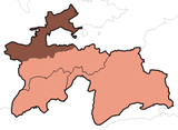
Spitamen District — District — Location of Spitamen District in Tajikistan Country  Tajikistan
Province Sughd Capital Nau Population (2003) – Total 98,600 Time zone TJT (UTC+5) Spitamen District is a district in north-central Sughd, Tajikistan, stretching across the province's narrow part from the border with Uzbekistan to the border with Kyrgyzstan. Population 98,600 (2003 data).[1] Formerly called Nau District (Russian: Науский район) or Nov District (Tajik: Nohiya-i Nov, Ноҳияи Нов; Persian: ناحیۀ ناو), it was renamed Spitamen district by a resolution of parliament in November 2003.[2] The district capital is Nau (Tajik: Нов, Nov), located south-west of Khujand at 40°8′59″N 69°22′12″E / 40.14972°N 69.37°ECoordinates: 40°8′59″N 69°22′12″E / 40.14972°N 69.37°E.
The district is named after Spitamen who led the Sogdians in a revolt against the forces of Alexander the Great in 329-328 BCE.[3]
Administrative divisions
The district is divided administratively into jamoats. They are as follows (and population).[4]
Jamoats of Spitamen District Jamoat Population Kurkat 21702 Kushtegirmon 6442 Nau 12910 Oqteppa 13879 Tagoyak 12047 Farmonkurgon 6246 Shahraki Nov 23578 References
- ^ Republic of Tajikistan, map showing administrative division as of January 1, 2004, "Tojikkoinot" Cartographic Press, Dushanbe
- ^ Renaming of Nau district to Spitamen district, Parliamentary Resolution No. 460, Majlisi Milli Majlisi Oli, 23 November 2003 (Russian).
- ^ B. Ghafurov, The Tajiks, Nauka Publ. House, Moscow (1972), pp. 93-97 (Russian).
- ^ "List of Jamoats". UN Coordination, Tajikistan. http://www.untj.org/files/minutes/Food/List_of_Jamoats.xls. Retrieved April 4, 2009.
 Sugd ProvinceCapital: Khujand
Aini District 

Asht District Ghafurov District Ghafurov · Utkansoy · Yova · Pakhtakor · Haidar Usmonov · Goziyon · Unji · Ismoil · Isfisior · Katagan · Ovchi Kalacha · KistakuzGhonchi District Isfara District Istarawshan District Istarawshan · Nijoni · Frunze · Kommunizm · Guli surkh · Poshkent · Pravda · Javkandak · Leninobod · Qalaibaland · NofarojKonibodom District Kuhistoni Mastchoh
DistrictMehron · Langar · Ivan TajikMastchoh District Panjakent District Jabbor Rasulov
DistrictShahriston District Shahriston · Yangiqo‘rg‘onSpitamen District Zafarobod District Categories:- Tajikistan geography stubs
- Districts of Tajikistan
Wikimedia Foundation. 2010.

