- Nahalat Shiv'a
-
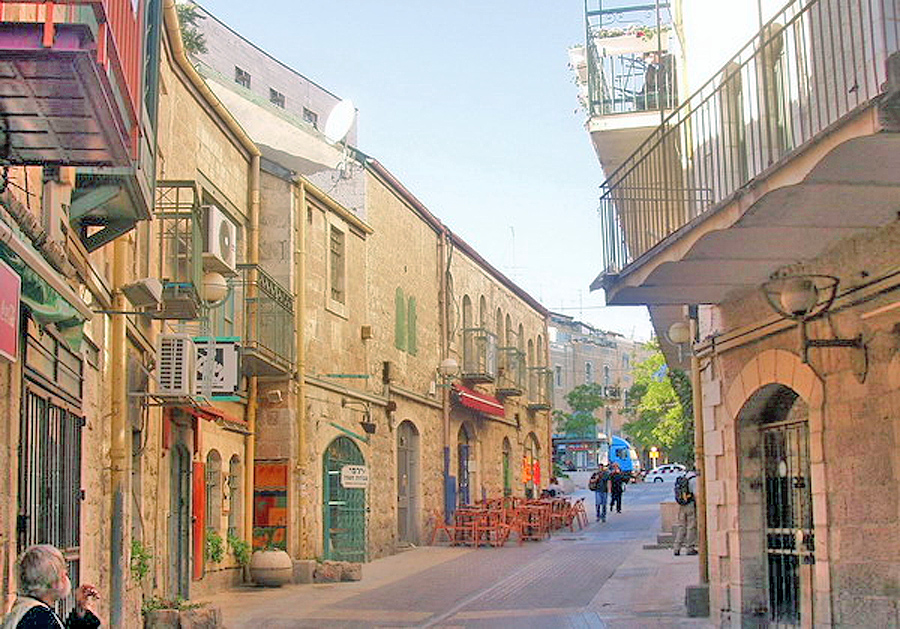
 Rivlin Street, Nahalat Shiv'a
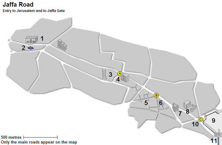
 Map of Nachalat Shiv'a Neighborhood, Jerusalem 1 Hillel Street 2 Ben Sira 3 Yafo 4 Shamai 5 Ben Yehuda 6 Generali B Kikar Tzion
Nahalat Shiv'a (Hebrew: נחלת שבעה) is a neighborhood in central Jerusalem, Israel.
Nahalat Shiv'a was the third neighborhood built outside the Old City of Jerusalem in the 1860s. Today it is a crowded pedestrian promenade lined with sidewalk cafes.
History
Nahalat Shiv'a was the third residential neighborhood built outside the city walls. It was founded in 1869 as a cooperative effort by seven Jerusalem families who pooled their funds to purchase the land and build homes. Lots were cast and Yosef Rivlin won the right to build the first house in the neighborhood.[1] In 1873, milk cows were imported from Amsterdam and a dairy was opened in Nahalat Shiv'a. A carriage service to Jaffa Gate was inaugurated that summer.[2]
Terrorist incidents
On October 9, 1994, Hamas carried out a shooting spree in Nahalat Shiv'a, using two Palestinian Authority policemen defectors.[3] Two people were killed and 16 wounded. Ma'ayan Levy, 19, and Samir Mugrabi, 35, were killed in the attack.[4]
References
Jaffa Road 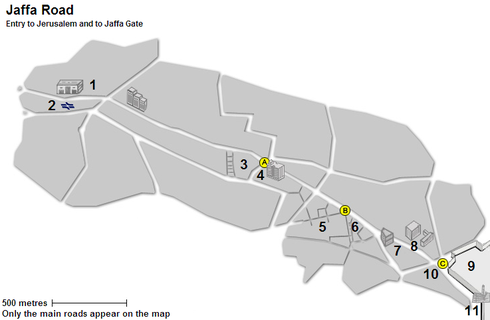
Places 1. Central Bus Station · 2. Railway station (planned) · 3. Mahane Yehuda Market · 4. Klal Center
5. Ben Yehuda Street · 6. Nahalat Shiva · 7. Generali Building · 8. Safra Square / City Hall · 9. Old City
10. Mamilla · 11. Jaffa Gate / Tower of DavidSquares A. Davidka Square · B. Zion Square · C. Tzahal Square · D. Safra Square Neighborhoods of Jerusalem Old City 
East Jerusalem American Colony • Al Bustan • Al-Issawiya • At-Tur • Bab a-Zahara • Beit Hanina • Jabel Mukaber • Ma'ale ha-Zeitim • Nachalat Shimon • Nof Zion • Ras al-Amud • Sheikh Jarrah • Shimon HaTzadik • Shuafat • Silwan • Sur Baher • Umm Tuba • Wadi al-JozHaredi neighborhoods Batei Munkatch • Batei Ungarin • Beit Yisrael • Ezrat Torah • Geula • Givat Shaul • Har Nof • Kerem Avraham • Kiryat Belz • Kiryat Mattersdorf • Kiryat Sanz • Kiryat Shomrei Emunim • Machanayim • Mea Shearim • Mekor Baruch • Nachalat Ya'akov • Ramat Shlomo • Ramot Polin • Sanhedria • Sanhedria Murhevet • Sha'arei Hesed • Shmuel HaNavi • Tel Arza • Unsdorf • Zikhron MosheCentral Neighborhoods Batei Nissan Bak • Beit David • Beit Ya'akov • Bukharan neighborhood • Even Yisrael • Ezrat Yisrael • Givat Ram • Katamon • Kiryat Shmuel • Kiryat Wolfson • Mahane Israel • Mahane Yehuda • Merhavia • Mishkenot Sha'ananim • Musrara • Nachalat Achim • Nachlaot • Nayot • Neve Sha'anan • Ohel Shlomo • Rehavia • Yemin MosheNorthern Neighborhoods French Hill • Givat HaMivtar • Ma'alot Dafna • Neve Yaakov • Pisgat Ze'ev • Ramat Eshkol • Ramot • Ramot PolinSouthern Neighborhoods Abu Tor • Baka • Beit Safafa • East Talpiot • The German Colony • Gilo • Givat HaMatos • Greek colony • Har Homa • Mekor Chaim • Ramat Rachel • TalpiotWestern Neighborhoods Bayit VeGan • Beit HaKerem • Givat Massuah • Givat Mordechai • Givat Oranim • Har Hotzvim • Ir Ganim • Katamonim • Kiryat HaYovel • Kiryat Menachem • Kiryat Moshe • Malha • Motza • Pat • Ramat Beit HaKerem • Ramat Denya • Ramat Sharett • Romema • Yefeh NofHistoric Neighborhoods See also: Ring Neighborhoods Coordinates: 31°46′49″N 35°13′09″E / 31.780373°N 35.219266°E
Categories:- Neighbourhoods of Jerusalem
- History of Jerusalem
- Terrorist incidents in 1994
- Deaths by firearm in Israel

Wikimedia Foundation. 2010.