Baxter railway station

Baxter railway station
BaxterBaxter
Baxter station platform and shelter
Station information
Code BXR
Distance from
Flinders Street
50.7 km
Operator Metro Trains Melbourne
Lines Stony Point
# Platforms 1
# Tracks 1
Status Unmanned Station
Metlink profile Link
Melway map Link
Google map Link
Metcard / Myki Zone 2

Baxter is a railway station in Melbourne, Victoria, Australia, located in the suburb of Baxter, on the Stony Point railway line. Baxter is unmanned and in Metcard Zone 2.

Contents

Facilities

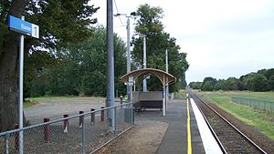
Baxter is located at the northern end of the Baxter-Tooradin Road level crossing, which also provides station access.

The station consists of one side platform, with a small steel shelter in the centre. Like all stations on the Stony Point line, the station contains no Metcard machine or validators, with passengers required to pre-purchase tickets and validate them on arrival at Frankston [1]

Myki readers and a top-up machine have been installed at the station.

Platforms and services

Platform 1:

  • Stony Point line - all stations services to Frankston, for connecting Frankston line services to Flinders Street
  • Stony Point line - all stations services to Stony Point

Bus services

History

Baxter station opened on 1 October 1888 as Mornington Junction.[2] It is the former junction of the Mornington railway line. The junction can still be seen at the Stony Point end of the station, though the points have been spiked and the line baulked just after the level crossing.

References

Langwarrin Station a former station on the Stony Point line is located between Leawarra and Baxter stations. Coordinates: 38°11′39″S 145°09′38″E / 38.1941°S 145.1605°E / -38.1941; 145.1605


Wikimedia Foundation. 2010.

Игры ⚽ Поможем написать реферат

Look at other dictionaries:

  • Baxter railway station, Melbourne — MelbourneRailwayStation1 NAME=Baxter IMAGELINK=Baxter railway station, Melbourne.jpg CAPTION=Baxter station platform and shelter CODE=BXR DISTANCE=50.7 km LINES=Stony Point PLATFORMS=1 TRACKS=1 STATUS=Unmanned Station FACILITIES= TIMETABLES=… …   Wikipedia

  • Moorooduc railway station — Mornington Railway Moorooduc Station Information Line Mornington Railway former Mornington Line Number of Platforms 1 Number of Tracks 1 Station status …   Wikipedia

  • Betchworth railway station — Infobox UK station name = Betchworth manager = First Great Western locale = Betchworth borough = Mole Valley code = BTO lowusage0405 = 12,214 lowusage0506 = 13,610 lowusage0607 = 14,503 platforms = 2 start = 4 July 1849Betchworth railway station… …   Wikipedia

  • Northam (North Devon) railway station — Northam Map showing the position of Northam station Location Place Northam Area …   Wikipedia

  • Somerville railway station, Melbourne — MelbourneRailwayStation1 NAME=Somerville CODE=SVE DISTANCE=55.6 km LINES=Stony Point PLATFORMS=1 TRACKS=1 STATUS=Unmanned Station FACILITIES= TIMETABLES= MELWAY= ZONE=2Somerville is a railway station in Melbourne, Victoria, Australia, located in… …   Wikipedia

  • Central railway station, Sydney — Cityrail Station alt| Central servicearea=South Coast Line|servicearea color=#South Coast line colour|servicearea textcolor=white servicearea2=Southern Highlands Line|servicearea color2=#Southern Highlands line colour|servicearea textcolor2=white …   Wikipedia

  • Leawarra railway station, Melbourne — MelbourneRailwayStation1 NAME=Leawarra IMAGELINK=Leawarra railway station, Melbourne.jpg CAPTION=Looking towards the platform from across the tracks CODE=LWA DISTANCE=44.6 km LINES=Stony Point PLATFORMS=1 TRACKS=1 STATUS=Unmanned Station… …   Wikipedia

  • Baxter, Victoria — Infobox Australian Place | type = suburb name = Baxter city = Melbourne state = vic caption = Main street of Baxter lga = Shire of Mornington Peninsula postcode = 3911 pop = 1873 (2006)Census 2006 AUS | id = SSC21055 | name = Baxter (State… …   Wikipedia

  • Rosebank (Metrorail station) — Infobox Station name=Rosebank type=Metrorail commuter rail station image size=300px image caption= address=Ryan Road, Rosebank, 7700 coordinates=coord| 33.9547|18.4731|type:railwaystation region:ZA|display=inline,title line=rail color… …   Wikipedia

  • Bideford, Westward Ho! and Appledore Railway — The Bideford, Westward Ho! and Appledore Railway (B, WH A, R) was most unusual amongst British Railways in that although it was built as a standard gauge (4 ft 8½ in (1435 mm)) line, it was not joined to the rest of the railway network, despite… …   Wikipedia

Share the article and excerpts

Direct link
Do a right-click on the link above
and select “Copy Link”